Tag:shop=medical_supply
Jump to navigation
Jump to search
 |
| Description |
|---|
| A store where you can buy medical equipment for private persons. |
| Rendering in OSM Carto |
| Group: shops |
| Used on these elements |
| Useful combination |
|
| Status: de facto |
| Tools for this tag |
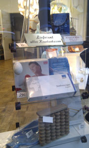
A store where you can buy medical equipment for private persons, where the primary products available at the store are medical supplies (e.g. Exercise balls, Bandages, Crutches, Arch support, Orthotics, Sphygmomanometers, Glucometer).
How to map
Set a node at the center of the shop or draw an area along its outline.
Tag it with shop=medical_supply.
In cases where the primary products are not medical supplies but where some medical equipment and supplies are available, consider using medical_supply=yes; for instance many multi-purpose stores which include a pharmacy also include some medical equipment as well, such as shop=supermarket + amenity=pharmacy.
Different types of medical supply you can tag with medical_supply=*.
Tags to use in combination
name=*(ornoname=yesif it has no name)addr:*=*- Addressphone=*/contact:phone=*- A telephone number associated with the objectwebsite=*/contact:website=*- Specifying the link to the official website for a featureopening_hours=*- Describes when something is open or closed (there is a specific standard format for this data)wheelchair=*- Indicate if a special place can be used with wheelchairsoperator=*- Сompany, corporation, person or any other entity who is directly in charge of the current operation of a map object
Example
-
Medical and Rehabilitation Store
See also
amenity=pharmacy- pharmacyshop=chemist- A shop selling articles of personal hygiene, cosmetics, and household cleaning productsshop=orthopedics
