Proposal talk:Couloir 2
Native English term?
Is there some native English term we could use instead of a French loanword? Getting the spelling of keys right when mapping is always an issue, and I fear this word is not an easy one. Even my spellcheck doesn't recognize it. Is a gorge too different from a couloir? --Mueschel (talk) 18:21, 3 February 2021 (UTC)
- I think not, this term might have been imported in the English language as is. Couloir in English speaking country are named " ... Couloir" (see this image for example). So, this term looks adopted in the English language (see wiktionary).
- And yes, it is very different, a gorge (Also a French word :) ) is a vertical and narrow "crevasse", so to say, made by a river or any other strong water flow. They are mostly in valleys and not "part of a cliff" (see the "gorge du Fier" for example).
- --Futur3r (talk) 18:38, 3 February 2021 (UTC)
- Couloir is a common term in the mountain hiking/climbing domain with a sufficiently concise meaning worldwide. E.g. German speaking mountaineers use it too, even though the locals say "Rinne". (Rinne and couloir both mean flow, but in our case its not water, but its rocks, so be careful there.) --Hungerburg (talk) 12:31, 8 February 2021 (UTC)
- Just to contradict my own words, I have one question for the proponent: A "Rinne" (our local term) is most simply characterized in that a rock, once rolling, almost always only stops at the end of the "Rinne", unlike in a "Reise", where it usually stops long before. Is this true of a couloir too? I'd thought so, but some of the pictures look otherwise. (This in no way shall question the "worldwide" above, which is evidenced by the tagging list thread.) --Hungerburg (talk) 13:17, 8 February 2021 (UTC)
- @Mueschel: Perhaps as a memory hook for Germans, kollern or kugeln . Does not help finding a simpler English term though. --Hungerburg (talk) 19:38, 8 February 2021 (UTC)
 Resolved
Some wording considerations
- The "rationale" section should be about the usefulness of mapping the subject.
That's now in the "intro", if I were asked, they could be swapped ;) - The word "alpine" should not appear in the text. Can be construed as discriminating and has been. Mountain… alone is fine.
- Somewhere it should say, that this is a strictly linear feature to be applied only to "ways".
- Great! We (in the Alps) do not think much, when we say alpine. But in the Himalayans or the Rockies people may wonder what its about.--Hungerburg (talk) 19:19, 8 February 2021 (UTC)
- Resolved
Associated tags proposition
Thanks for this usefull proposition. Imho, those informations should be added :
- altitude of both extremity of the couloir(with a ele=* on both extremity node ? not the best, but I'm not sure ele_min=* and ele_max=* already exists)
- maximum inclination of the couloir (very usefull to avoid avalanche)
- main orientation of the couloir (very usefull to avoid avalanche)
- as most of the couloir are skiable, it should add the ski difficulty or "no" if it's not skiable at all (too much rocks, etc...)Babouche Verte (talk) 21:01, 3 February 2021 (UTC)
- The tag natural=couloir is more a description of the topology rather than a path to follow. So it would be more logical that the data of elevation and maybe even inclination is extracted from elevation data.
- I think it could be possible to add an incline=* tag and specify to use it as the maximum of inclination of a couloir but it would be more logical to extract it from elevation data on a specific path (like piste:type=skitour).
- For the difficulty, you can use the tag piste:type=skitour and piste:difficulty=* to specify the exposition and difficulty of the "path". Also you can use various tools (like OpenSnowMap) to show you a topological graph with maximum and minimum elevation of a specific way.
- The natural=* tags in general, just describe topological features of the terrain, not a specific path. Maybe some tools can use wikidata tags to query specific information for the known min/max elevation and inclination of a couloir.
- --Futur3r (talk) 23:09, 3 February 2021 (UTC)
- I saw that you add the orientation to the additional tags, thanks.
- for altitude of both extremity and inclination, it is indeed a geographical / topologic information corresponding to the couloir. So, as for Tag:natural=peak it should be included in. I don't see any reason to not include it. The fact that you can extract it from elevation data is not so right : as a couloir is most of the time in very steep area, with a complex ground, it's more or less impossible to have an accurate elevation by extracting elevation of a point from a elevation data.
- I understand your point for not including ski or alpinism difficulty. So in your opinion, you should have 3 objects : one for physical couloir, one for the couloir as a skiing path and the third for the couloir as an alpinism path ?
- it should be possible to have additional Key:website tag, with a link to a participative website (for exemple Camp to camp (couloir Couturier exemple) in France). The question, if you separate the physical and sportive element, on which object do you add the link ? That's why I think it would be easier to have all in one object (both sportive and physical path).
- Babouche Verte (talk) 20:05, 4 February 2021 (UTC)
- Regarding the orientation: The current wording is a quite broken and more importantly not completely clear. There are two relevant established tags: direction=* and incline=*.
- The first one has been used in the past to indicate the direction of stairs, but that is deprecated in favor of incline.
- Therefore I think incline is better for couloirs but both could be used together.
- I don't see a point in doing so though: if it is clear which direction is up we don't need to describe the orientation further since this is a linear feature and the geometry is of course inherent to the way :)
- --Stefanct (talk) 01:08, 5 February 2021 (UTC)
- I see that you have added the incline=* now in the more genuine way than just up/down (as I was expecting/describing above) that's good and probably useful to data users.
- It also makes the direction=* tag necessary/useful. In the current proposal it is unclear which way a couloir is actually facing.
- I don't know if mountaineers have a definition for that, i.e. if you say "that's a north-east couloir" if its lowest point is in the south-west and the peak is on the north-east, or the other way around, or if you wouldn't say that at all.
- This might also be language-specific! In any case it needs to be clearly stated in the wiki what we mean.
- The other point that I was referring to previously is "This way should be go by lowest points of couloir."
- I cannot parse that sentence at all. I thought it was connected to the incline description and just formatted badly but since it is still there, I don't know its purpose.
- Regarding ele=*: I'd favor to tag it on individual nodes. First of all, it makes the meaning very clear - no new tags, no workarounds and the tag is at the point where it is valid.
- Secondly - and I don't know if that's useful at all - it makes it easily possible to tag a node in the middle with ele=* too and handle it just like that others in algorithms.
- As I said I am not sure if that is useful (maybe there exist significant points within couloirs? maybe GPS is only precise somewhere in the middle? Quite unlikely I guess :) but even without that I think tagging the top and bottom nodes is they best options.
- --Stefanct (talk) 03:38, 6 February 2021 (UTC)
- Sorry for the late answer,
- for the elevation, the tags min_ele=* and max_ele doesn't exist or are not in use, so to add this data in osm, I see only one ele=* tag at the top node and one on the bottom node.
- But would these data show up on the object itself directly ? Or would tools need to adapt themselves to make the link beetween the nodes on the way and the way itself ?
- If a wikidata query is out of the question then just using the tag ele=* with two values separated by a semicolon, the first for the minimum and the second for the maximum ?
- What is the problem with wikidata ?
- For the three path : Sure, you can filter out either one without impacting the other. Having a path using a natural=* way doesn't look logical, you are not gonna use a way with natural=valley for example to route someone down a valley.
- Also, a skitour path might not use the same path as the center of the couloir like the hiking path doesn't, neither the climbing path.
- For the website, still looks weird. Would adding the camp to camp website on a hiking path, peak or couloir is thoughtful ? There could be a multitude of other websites in different languages that can describe routes using either one of these features. Just letting router engines using these path would be enough or linking the object via wikidata.
- --Futur3r (talk) 23:05, 5 February 2021 (UTC)
- Resolved
Lack of a meaningful definition
I would strongly advise against trying to introduce a new tag by copying some vague text from Wikipedia full of weasel words (may, often, significant, noticeable) and calling it a definition.
Think of what you would like to map independent of culture specific terms like 'couloir', think about how that relates to already existing tags and either create a subtag for those or a new tag which you clearly delineate towards these tags. This way you will have a much better chance to create a successful tag that is consistently used all over the world making the mapping meaningful and useful for data users.
--Imagico (talk) 22:24, 8 February 2021 (UTC)
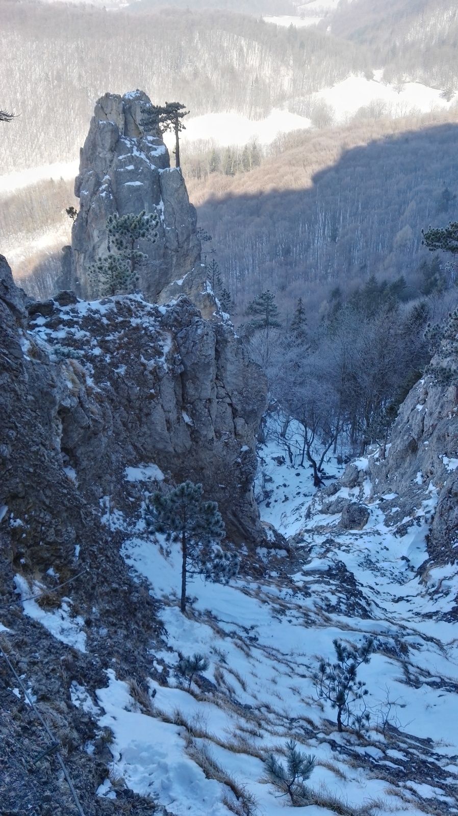
As much as I too consider the definition lacking in precision, I also do not see there being an existing tag, that might be a good choice to extend. I just mapped six couloirs, from what I consider such, risking to give away places fun for skiing - Not that I ride all of them ;) One has at least three web sources - https://www.openstreetmap.org/way/905621702, of those, one is also available in British English - https://www.gore-tex.co.uk/blog/weekend-warriors-seriously-steep-slopes (I do not endorse the brand!) - there they call it alternatively couloir and gully. Please look and you will see, why gully is not a good base. The most famous couloir in Austria, the Pallavicini Rinne https://www.openstreetmap.org/way/905621701 is up to 60 degrees, practically a wall at times, so not suitable for skiing. A more modest is the "Couloirstiege", a hiking trail near Vienna, picture taken from the inside of it - https://vcdn.bergfex.at/images/resized/profiles/detail/499/c7ecbf5bc9d65be5f58c03f19c998499.jpg - I will leave it up to the proponent to explain even more modest examples. PS: JOSM warned, "not closed natural type" --Hungerburg (talk) 23:09, 9 February 2021 (UTC)
Continuing the search for a better definition: In my vicinity some local bloggers use couloir in their stories. They generally also drop some geological facts on the terrain, so I consider their texts well-founded. It is a bit of a curiosity though, how they use the term, exclusively so; some pictures in this tour description - https://www.spitzentreffen.at/figln-rosenjoch-2-796-m/ - also with skiers :) Not sure if that is good news or bad news for this proposal, all it says, couloir is a bit wide in what topologies it covers. The current definition reflects that through vagueness. While these couloirs look like reverse ridges, the ones I reported yesterday look like a reverse arete. Lacking a truly accurate German word, I'd call it a "Mulde". A translation revealed "runnel" among others. Native speakers to the rescue! Will that mean a subtag is needed to match the breadth? --Hungerburg (talk) 19:08, 10 February 2021 (UTC)
- I agree that we need a better definition before approving this tag. On the tagging list it was said that " A couloir is a narrow gully with vertical sides (usually of rock) and a steep slope. Around here, the usual term is 'rock chute' rather than 'couloir', but the terms are nearly synonymous. Not every gully is inclined enough, or has enough gradient, to be called a couloir or rock chute. Where does the couloir end and the talus begin? Where there are no longer walls on either side. Which means that there's no longer a gap to be loaded with snow in a crosswind, so you tend to get very different ice conditions." However, I get the impression that a small, steep stone canyon in a desert (e.g. Utah, Arizona) would not necessarily be called a Couloir or "rock chute" if it is never covered in stone or ice. Is that correct? Does a couloir also need to have a snow-covered central portion during the cold season? All the example images in searches seem to have snow filling the "chute." --Jeisenbe (talk) 23:31, 18 February 2021 (UTC)
Valley definition
"it has multiple ridges and summit and have been made by rivers and big glacier in the last ice age" - many valleys were formed by a stream and never had a glacier. (example) Mateusz Konieczny (talk) 20:44, 18 February 2021 (UTC)
What is supposed difference from a gorge?
https://wiki.openstreetmap.org/wiki/Proposed_features/couloir_2#From_a_gorge has just (quite unclear) gorge definition, and no mention how it differs from couloir. Mateusz Konieczny (talk) 20:46, 18 February 2021 (UTC)
Examples
1) Is this gully a couloir: https://www.americansouthwest.net/california/death_valley/golden-canyon-gully_l.html 2) What about these gullies: https://cdn2.apstatic.com/photos/climb/105848296_medium_1557863064.jpg 3) Or this steep slot canyon: https://www.roadtripryan.com/go/resources/content/utah/moab/sgr-canyon/user-submitted/xryancornia-1488896313480.jpg.pagespeed.ic.VxV1KW4RTx.jpg If not, why not? Is it the lack of snow which is important, or some other characteristic? --Jeisenbe (talk) 23:32, 18 February 2021 (UTC)
Couloir=Żleb?
Wikipedia claims that this terms are equivalent ( https://pl.wikipedia.org/wiki/%C5%BBleb ).
Is Staników Żleb ( https://2.bp.blogspot.com/-Yb8DpNSUMKs/VJWy9bSdYbI/AAAAAAAAAtw/trBSXukqnrM/s1600/Tatry%2B2014%2B039.jpg https://gdziebytudalej.pl/tatry-2008-09/04-przez-stanikow-zleb-na-przyslop-mietusi/ https://mapio.net/wiki/Q9341478-pl/ taggable as natural=couloir?
I guess no (Wikipedia article mentions it as extreme case). Are there similar things named "Something Couloir" and not actually couloir? Maybe mention it explicitly that characteristics matter, not the name?
Wikipedia page for żleb also claims that difference between couloir and valley (or at least between "żleb" and "dolina") is not clear, with some objects borderline (that is not disqualifying tag - waterway=stream and waterway=river are useful despite some objects on the border or part of the name mismatching correct OSM tag) Mateusz Konieczny (talk) 04:39, 19 February 2021 (UTC)
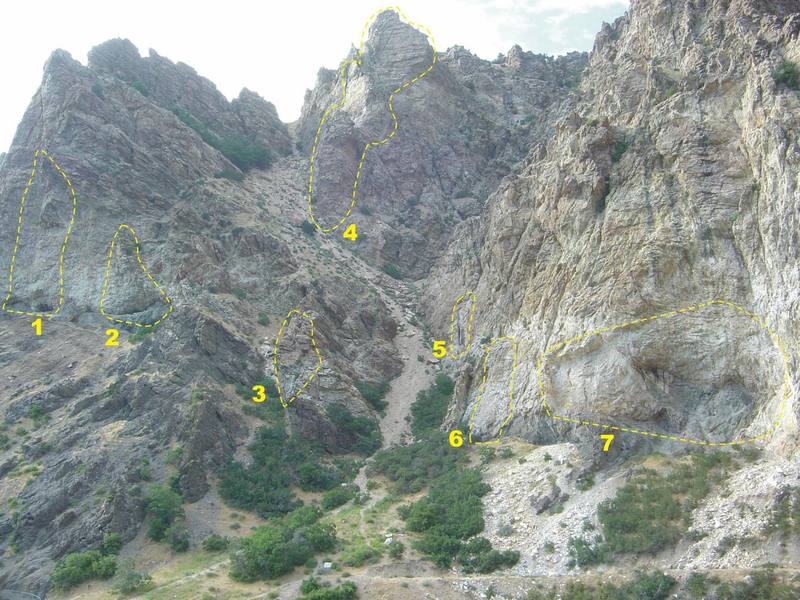
- Half of the worlds couloirs (of those mapped in OSM) are in Slovenia (mostly around Triglav). Many have names, and from the aerial are true couloirs/gullies, some even rock chutes. Likely most of them added by the same user, someone certainly local to the region. Curiously, drawn from bottom up, like an arete (points at couloir being more about routabilty than about nature). Some are called grapa, which is Tobel in German, according to DeepL, a certain kind of gorge. Perhaps there is similar term in Poland?. The high resolution aerial does not show a Tobel. One is on the Italian border, where OSM has a "torrente" (intermittent stream) running there, but there is no water there, its a scree. For sure, the naming in Italy stems from imports of OG data, where the stream *must* go to the watershed by definition ;) --Hungerburg (talk) 23:43, 22 February 2021 (UTC)
Which scale
"A gully is a small scale land form (a meters to a few tens of meters)" - is it about length or width? Mateusz Konieczny (talk) 07:52, 21 February 2021 (UTC)
Gully?
From reading up on the subject, gully looks like a good general term. Unfortunately, gully already has an article/page, that is not the least helpful due to limiting the feature to erosion by water. Not a native speaker, I have to consult the dictionary, eg. https://www.britannica.com/science/gully says just the same. On the other hand, what is often synonymously called gully, chute or couloir on a myriad of webpages, by native speakers too, is quite often not created by obvious fluvial or even glacial erosion, but by other physical weathering (frost, heat, disintegration by shifted layers). If these are steep, gravity is all it takes to carry the debris, rain and snow can only speed up the process. Beware, not a geologist speaking neither, but have read such in geological literature. [German only though paper on torrent control.] Can gully be adapted to match that?--Hungerburg (talk) 11:59, 21 February 2021 (UTC)
- Steinerne Rinne is purely formed by erosion (geological paper), inside views https://vimeo.com/106715068 - rock polished by rocks and water --Hungerburg (talk) 09:47, 22 February 2021 (UTC)
- Of course, Mateusz beat me to it, https://www.openstreetmap.org/way/909790292 - Still I had to remap, a gully/chute/couloir is a linear feature, mapped from the top to the bottom, following gravities pull. Steinerne Rinne translates to Rocky Chute in English. Never been to this one, but in others, pebbles whistle while flying overhead. --Hungerburg (talk) 23:28, 22 February 2021 (UTC)