User:LA2/Diary for Q3 2006
LA2's OpenStreetMap Diary for the 3rd Quarter of 2006
September 29, 2006: Beginning of the mapping weekend in Växjö, which see.
September 28, 2006: I've drawn Ulricehamn and riksväg 40 a little beyond Borås from tracks I collected on my way home from the Göteborg Book Fair last Saturday. There are tracks for some more motorway exits on riksväg 40 to be drawn between Borås and Göteborg. Next year, more of rv40 will be motorway. I saw the construction of a valley bridge just east of Borås.
One thing that has surprised me about my new Mio P550 device with an integrated GPS receiver based on the new SiRFstar III chip is that its altitude reading seems to vary a lot. Today I decided to calibrate it against my older Garmin Foretrex 201. I took both receivers with me to a park where the sky is open and the surrounding buildings are low, while spending a little more than an hour drinking coffee and reading magazines. The diagram below shows the altitude as measured by the two receivers. I believe the true altitude of this park is 69 metres above sealevel. When you see the diagram, it's hard to believe I was sitting still all the time. At some points, such as A and E, the trends of the two receivers seem to be opposites: one has a maximum while the other has a minimum. While at other times, such as B and D, the trends agree even if the exact measurements almost never do. If you look closer, you see that the blue line (Mio) fluctuates more than the red one (Garmin) before point C, where the roles change. This I can explain. Before C, both receivers were laying flat on a table. For the Garmin this means its patch antenna was facing the sky, which is an optimal position, but the Mio has its rather small antenna pointing towards the edge of the unit. At point C I changed this so both units were standing up, leaning against some magazines. This upright position seems optimal for the Mio but worsened the reception for the Garmin. As with all radio communication, it turns out the position of the antenna is the key to good signals. Conclusion: I think I should get an external antenna for my car. The Mio has a connector for this.
Here is a discussion thread about the internal antenna of the P550 and its cousin P350. That thread started when some owners found their P550 had surprisingly poor GPS reception (I don't have that problem). This later turned out to be a manufacturing problem with 9% of the early units, and Mio has recalled these. But during the search, these owners provided photos and details about their experience. It's an interesting read.
GPSdash seems to be an interesting program.

September 27, 2006: Useful programs for the Mio P550 (running Windows Mobile 5): WiFiFoFum wardriving, and PocketPuTTY SSH. -- The tile server, and thus OpenStreetMap's "slippy map", is back in operation. However, it is neither fast nor perfect. Here's the very first example I saw today. As you can see, streets are missing from the tile in the center of Linköping.

September 25, 2006: Not only is OSM's slippy map completely broken since the beginning of this month, now the server hardware is also standing still after a power failure. I've now changed all European map links on susning.nu to point to london.freemap.in instead. See for example Amsterdam, Berlin, Bristol, Köpenhamn, London, Frankfurt, Oslo, Paris, Stockholm.
September 22, 2006: I've got a new toy, a Mio P550, also called Digiwalker, and have started to play with it. This is a PDA that runs Windows Mobile 5.0 and has built in WLAN (IEEE 802.11b+g), Bluetooth, and GPS (the new SiRFstar III chip). I recommended Eriso to buy one this spring, and he seemed satisfied with it, so now I bought one for myself. This unit has everything except a phone. That's fine because I'm happy with my old and simple GSM phone. It is not the most advanced PDA on the market. For example, some models now have VGA (640x480) screens, but the Mio P550 only has 320x240. The included maps cover Europe (on CDROM, can be transferred to SD-card in whole or parts) and Scandinavia (on an included SD-card). The maps appear to be from the same source as used by Google, which contain the mishyphenation "Gott-Fridsberg".
Following the recommendation on the Making Tracks with Homebrew-ware page, I installed the freeware VisualGPSce v1.2 for collecting NMEA tracks and it works fine. However, after I also installed and used the included software Mio Map 2.0, VisualGPSce no longer shows satellite signal strengths or positions. The new NMEA logs don't contain any GPGSV (satellites in view) commands. Mio Map apparently tells the SiRF chip not to send this information, and VisualGPSce doesn't know how to reactivate them. This discussion thread talks about a WinCEmonitor utility that can remedy this. However, a better solution is to upgrade from VisualGPSce (freeware) to BeeLineGPS v1.77 ($30, free 30 day trial). This program knows how to instruct the SiRF chip to report GPGSV. BeeLineGPS also supports Geocaching and shows a map of the current track.
On the Mio P550, COM2 is the hardware GPS port and the system contains a setting for sharing this between applications over COM4. This means Mio Map street navigation can be used at the same time with VisualGPSce. For this to work, Start menu -> Settings -> System -> GPS -> Access must be set to "Manage GPS automatically". Flip back to the "Programs" tab and make sure the "GPS program port" is set to COM4. Then in VisualGPSce -> Connect -> Serial Port, set Port to COM4. BeeLineGPS automatically finds COM4. Make sure you get a fix and start logging. This means Mio P550 owners will not have to resort to the trick described by user:Blackadder, who bought and installed the separate program GPSGate for GPS port sharing on his Acer n35.
What do I need right now:
- A good solution for syncing this PDA with Linux
- A good solution to transfer my old Palm Pilot address book and calendar to this Windows PDA
- A cover that protects the buttons and screen of the PDA
- A screen protector so the glass doesn't wear out when I use "block recognition" (Windows' equivalent to Palm's Graffiti)
- A PDA application that supports OpenStreetMap
September 19, 2006: On March 3, 2006, I wrote about the Swedish national road database (NVDB). Today I learned that the EuroRoadS initiative aims to establish something similar on a pan-European level. The Swedish road administration (vägverket), national land survey (lantmäteriet) and the British Ordnance Survey are already partners in this development.
EuroRoadS, the pan-European Road Data Solution, was a 30 month prestudy and development project (March 2004 - August 2006). Its 3.7 million euro budget was 50% funded by the EU eContents program and the other half by its founding partners, which include the British Ordnance Survey, the Swedish national land survey and some similar organizations. Its aims have been "to build a platform for a European road data solution through a specification framework consisting of a road data structure, description of data content, data exchange mechanisms and interoperability specifications. The framework will be built on identified user requirements and tested through a prototype" (italics as quoted from their brochure). A closing EuroRoadS workshop was held on June 27, 2006 in Brussels. A special session on EuroRoadS will be held at the ITS World Congress in London on October 9, and a meeting on the proposed memorandum of understanding will be held in Malmö, Sweden, on November 30, 2006.
The problem with identifying user requirements is to know who the (future) users are. Let me guess that the open source mapping community is not among the identified user base. There's a lot of talk about "stakeholders" and little mention about how to prepare access to outsiders and upstarts.
D6.1 page 6: Different content providers ideally shall be viewed as keepers of data of a certain domain or possibly also competing providers of data for the same domain.
September 4, 2006: From the changes made on Thursday August 31 until today Monday, tile rendering was very fast and only gave thin white lines, no fat colored lines for primary roads and motorways. Since Monday the colors are back and the rendering is slower again, albeit maybe not quite as slow as before Thursday. I'm also occasionally seeing all-white tiles and tiles with no streets rendered. So the changes on Monday are definitely for the worse. It seems load average on the db server is climbing high again.
September 3, 2006: On the Orkneys, roads were apparently auto-generated from multiple tracklogs. There are also plenty of tracks and roads on Iceland, thanks to FredB.
September 2, 2006: Here's how the nodes in the planet.osm files for 2006 are distributed over UTM zones.

| Zone | Aug 27 | Aug 18 | Aug 14 | Aug 8 | Jul 3 | May 1 | Apr 2 |
|---|---|---|---|---|---|---|---|
| Alaska | |||||||
| 59U | 0 | 0 | 0 | 526 | 526 | 526 | 0 |
| 60U | 0 | 0 | 0 | 656 | 656 | 656 | 0 |
| 1U | 0 | 0 | 0 | 1689 | 0 | 0 | 0 |
| 1W | 469 | 469 | 0 | 0 | 0 | 0 | 0 |
| 2U | 0 | 0 | 0 | 315 | 0 | 0 | 0 |
| 2V | 0 | 424 | 424 | 1530 | 0 | 0 | 0 |
| 2W | 631 | 829 | 198 | 198 | 0 | 0 | 0 |
| 3U | 0 | 0 | 0 | 3307 | 0 | 0 | 0 |
| 3V | 0 | 3294 | 6623 | 6623 | 0 | 0 | 0 |
| 3W | 0 | 11712 | 11712 | 11712 | 0 | 0 | 0 |
| 4U | 0 | 273 | 273 | 1026 | 0 | 0 | 0 |
| 4V | 4687 | 10566 | 26390 | 26614 | 0 | 0 | 0 |
| 4W | 1845 | 12429 | 12429 | 12429 | 0 | 0 | 0 |
| 5V | 2231 | 66760 | 68434 | 68439 | 0 | 0 | 0 |
| 5W | 6592 | 13964 | 14048 | 14048 | 0 | 0 | 0 |
| 6V | 17 | 67029 | 101563 | 117482 | 0 | 0 | 0 |
| 6W | 8653 | 21865 | 64836 | 64836 | 0 | 0 | 0 |
| 7V | 0 | 10491 | 10491 | 10491 | 0 | 0 | 0 |
| 7W | 674 | 3320 | 3320 | 3320 | 0 | 0 | 0 |
| 8U | 0 | 4765 | 4765 | 4765 | 0 | 0 | 0 |
| 8V | 0 | 14559 | 26626 | 26626 | 0 | 0 | 0 |
| 9U | 0 | 10993 | 10993 | 10993 | 0 | 0 | 0 |
| 9V | 0 | 265 | 265 | 265 | 0 | 0 | 0 |
| North America | |||||||
| California 10S | 706165 | 706162 | 706162 | 706162 | 0 | 0 | 198 |
| Oregon 10T | 1917669 | 1917669 | 1917669 | 1917669 | 0 | 0 | 16 |
| British Columbia 10U | 12168 | 12168 | 12168 | 12168 | 0 | 0 | 6 |
| 11S | 4145 | 4109 | 3945 | 3945 | 0 | 0 | 2278 |
| 11T | 17297 | 16440 | 15783 | 13890 | 0 | 0 | 38 |
| 11U | 11 | 11 | 11 | 11 | 0 | 0 | 11 |
| 12S | 309 | 309 | 309 | 0 | 0 | 0 | 0 |
| 12T | 60053 | 60053 | 60018 | 60018 | 0 | 0 | 0 |
| 13T | 35938 | 35938 | 35938 | 35938 | 0 | 0 | 0 |
| 13U | 81527 | 81527 | 81527 | 81527 | 0 | 0 | 0 |
| 14Q | 1 | 1 | 1 | 1 | 0 | 0 | 0 |
| 14R | 191183 | 191183 | 191183 | 191183 | 0 | 0 | 0 |
| 14S | 156954 | 156954 | 156954 | 156954 | 0 | 0 | 0 |
| 14T | 87983 | 87983 | 87983 | 87983 | 0 | 0 | 0 |
| 15R | 578096 | 578096 | 578096 | 578096 | 0 | 0 | 0 |
| 15S | 153557 | 153559 | 153559 | 153559 | 0 | 0 | 314 |
| 15T | 133277 | 133277 | 133277 | 133277 | 0 | 0 | 205 |
| 16R | 2249364 | 2249364 | 2249364 | 2245771 | 0 | 0 | 0 |
| 16S | 4929649 | 4797014 | 4505795 | 3794197 | 0 | 0 | 528 |
| 16T | 353984 | 353984 | 353984 | 353984 | 0 | 0 | 1864 |
| 17R | 383 | 383 | 383 | 383 | 0 | 0 | 363 |
| 17S | 245199 | 245199 | 165227 | 153485 | 0 | 0 | 1 |
| 17T | 2647 | 2647 | 2647 | 2647 | 0 | 0 | 8 |
| 18S | 230649 | 230649 | 230649 | 230649 | 0 | 0 | 4466 |
| 18T | 19577 | 20505 | 20658 | 31268 | 0 | 0 | 12036 |
| 19T | 37 | 102 | 102 | 102 | 0 | 0 | 1245 |
| 20T | 929 | 929 | 759 | 478 | 0 | 0 | 0 |


| Zone | Aug 27 | Aug 18 | Aug 14 | Aug 8 | Jul 3 | May 1 | Apr 2 |
|---|---|---|---|---|---|---|---|
| South America | |||||||
| Peru 18L | 1 | 1 | 0 | 0 | 0 | 0 | 0 |
| Chile 19H | 1788 | 247 | 237 | 236 | 0 | 0 | 236 |
| Dominican Republic 19Q | 95 | 95 | 95 | 95 | 0 | 0 | 0 |
| 20K | 29 | 29 | 29 | 29 | 0 | 0 | 29 |
| Argentina 21H | 6 | 6 | 6 | 6 | 0 | 0 | 6 |
| Argentina 21J | 1 | 1 | 1 | 1 | 0 | 0 | 1 |
| Argentina 22J | 2 | 2 | 2 | 2 | 0 | 0 | 2 |
| Brazil 23K | 559 | 559 | 559 | 559 | 0 | 0 | 559 |
| Africa | |||||||
| 29N | 0 | 0 | 0 | 0 | 0 | 1 | 1 |
| 30N | 0 | 0 | 0 | 0 | 0 | 2 | 2 |
| 31N | 0 | 0 | 0 | 0 | 0 | 2 | 2 |
| Europe | |||||||
| Iceland 27V | 168 | 140 | 89 | 0 | 0 | 0 | 0 |
| Iceland 27W | 400 | 244 | 110 | 0 | 0 | 0 | 0 |
| Iceland 28V | 411 | 411 | 0 | 0 | 0 | 0 | 0 |
| Iceland 28W | 1816 | 1622 | 175 | 0 | 0 | 0 | 0 |
| Portugal 29S | 186 | 187 | 135 | 135 | 3 | 3 | 0 |
| Ireland 29U | 22187 | 22022 | 21553 | 18272 | 12274 | 7164 | 6516 |
| Scotland, Faroes 29V | 430 | 430 | 236 | 236 | 54 | 54 | 7 |
| Spain 30S | 7397 | 682 | 682 | 682 | 220 | 220 | 219 |
| Spain 30T | 6391 | 6347 | 6347 | 6347 | 5558 | 4515 | 2936 |
| England 30U | 441775 | 387437 | 355092 | 338464 | 266730 | 186973 | 152905 |
| Scotland 30V | 21935 | 21909 | 17579 | 17557 | 8839 | 8285 | 6034 |
| 31S | 6 | 6 | 6 | 6 | 6 | 6 | 4 |
| France 31T | 84979 | 78703 | 76064 | 75184 | 48281 | 29478 | 19393 |
| London, Paris, Antwerp 31U | 86314 | 69982 | 68230 | 64527 | 52598 | 35517 | 33301 |
| 32S | 2 | 2 | 2 | 2 | 2 | 0 | 0 |
| Italy 32T | 68717 | 65560 | 63943 | 63965 | 52398 | 20202 | 13934 |
| Denmark, Germany 32U | 161519 | 159598 | 159051 | 156743 | 133116 | 102661 | 96332 |
| Denmark, Norway 32V | 51525 | 51216 | 50774 | 49214 | 29543 | 25114 | 22363 |
| Malta 33S | 269 | 269 | 269 | 269 | 269 | 269 | 266 |
| Austria, Italy 33T | 12927 | 8629 | 7916 | 7540 | 6528 | 2954 | 2430 |
| Denmark, Poland, Czech 33U | 63214 | 58430 | 57950 | 53996 | 45388 | 27135 | 19060 |
| Denmark, Sweden 33V | 118307 | 116677 | 116271 | 113129 | 101903 | 70882 | 68941 |
| Sweden 33W | 4918 | 4918 | 4918 | 4918 | 4918 | 4651 | 4382 |
| Greece 34S | 763 | 763 | 763 | 763 | 763 | 763 | 628 |
| 34T | 921 | 921 | 905 | 880 | 868 | 44 | 44 |
| Poland 34U | 451 | 420 | 309 | 288 | 217 | 41 | 1 |
| Stockholm 34V | 10978 | 10973 | 10973 | 10973 | 8519 | 5688 | 5098 |
| 34W | 2209 | 2209 | 2209 | 2209 | 2153 | 1776 | 1362 |
| 35S | 6 | 6 | 6 | 6 | 6 | 0 | 0 |
| 35T | 1831 | 1769 | 1224 | 1224 | 1156 | 1156 | 533 |
| Estonia 35V | 17922 | 17922 | 17902 | 17900 | 11412 | 9948 | 8515 |
| 35W | 4633 | 4633 | 4633 | 4633 | 3871 | 3316 | 3316 |
| Cyprus 36S | 2769 | 2769 | 2769 | 1130 | 1123 | 530 | 35 |
| Black Sea 36T | 68 | 68 | 68 | 68 | 0 | 0 | 0 |
| 36U | 561 | 561 | 561 | 561 | 67 | 67 | 67 |
| Petersburg 36V | 20597 | 20597 | 20597 | 20597 | 16537 | 15209 | 15090 |
| Murmansk 36W | 10167 | 10167 | 10167 | 10167 | 9354 | 7423 | 7423 |
| 37U | 2 | 2 | 2 | 2 | 2 | 2 | 0 |
| 37V | 6 | 6 | 6 | 6 | 6 | 6 | 6 |
| 38S | 29 | 29 | 29 | 29 | 29 | 29 | 29 |

| Zone | Aug 27 | Aug 18 | Aug 14 | Aug 8 | Jul 3 | May 1 | Apr 2 |
|---|---|---|---|---|---|---|---|
| Middle East, Asia | |||||||
| Israel 36R | 156 | 156 | 156 | 156 | 156 | 156 | 0 |
| Iraq 39S | 2 | 2 | 2 | 2 | 2 | 2 | 2 |
| India 43P | 16 | 16 | 16 | 16 | 0 | 0 | 0 |
| India 44R | 9 | 9 | 9 | 9 | 9 | 9 | 0 |
| India 45Q | 1 | 0 | 0 | 0 | 0 | 0 | 0 |
| Thailand 47N | 1 | 1 | 1 | 1 | 1 | 1 | 1 |
| China 49Q | 3 | 3 | 3 | 3 | 3 | 3 | 3 |
| China 50Q | 309 | 309 | 309 | 309 | 309 | 309 | 309 |
| China 50S | 1 | 1 | 1 | 1 | 1 | 1 | 1 |
| Philippines 51P | 1072 | 1072 | 1072 | 1072 | 0 | 0 | 0 |
| Taiwan 51Q | 1318 | 1318 | 1318 | 1318 | 773 | 773 | 0 |
| China 51R | 2 | 4 | 4 | 4 | 4 | 4 | 2 |
| China 53U | 6 | 6 | 6 | 6 | 6 | 0 | 0 |
| Australia, New Zealand | |||||||
| W. Australia 50H | 1 | 1 | 1 | 1 | 1 | 0 | 0 |
| S. Australia 54H | 4 | 4 | 4 | 4 | 4 | 4 | 4 |
| S. Australia 55H | 1840 | 1560 | 1543 | 1236 | 668 | 565 | 128 |
| SE. Australia 56H | 19718 | 7779 | 7649 | 6824 | 2884 | 464 | 91 |
| E. Australia 56J | 17610 | 982 | 982 | 982 | 16 | 16 | 16 |
| New Zealand 59G | 64 | 64 | 64 | 64 | 64 | 0 | 0 |
| New Zealand 60G | 22 | 22 | 22 | 22 | 22 | 22 | 22 |
| New Zealand 60H | 2542 | 2542 | 2542 | 2542 | 2542 | 2429 | 337 |
| South Pacific 60N | 1 | 1 | 1 | 1 | 1 | 1 | 1 |
September 1, 2006: The twenty most active map editors in August 2006 (where Ben has been importing TIGER data for the U.S.) were:
| Edits | User |
| 1697197 | Tiger Import |
| 498318 | (anonymous) |
| 116273 | (anonymous) |
| 79571 | Joerg Ostertag |
| 67285 | MichaelCollinson |
| 37380 | Dutch |
| 17929 | Alban |
| 14419 | Gabriel Ebner |
| 14133 | 80n |
| 13214 | Ben |
| 13030 | jrglasgow |
| 11523 | OJW |
| 11215 | blackadder |
| 8374 | dmgroom |
| 8253 | LjL |
| 6982 | FrankM |
| 6477 | tgomas |
| 6104 | Dean Earley |
| 5757 | wollschaf |
| 5375 | TM |
| 4698 | Chris Morley |
| 4578 | LA2 |
| 4516 | Nick Hill |
August 31, 2006: On mid day, Steve installs new code with improved SQL for the tile rendering. Database load goes down, performance goes up, and everybody is happy.
-
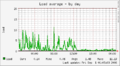 Db server, load average for the day...
 -
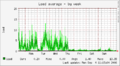 ...and for one week
 -
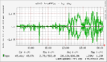 Tile server, network throughput for the day...
 -
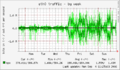 ...and for one week


August 27, 2006: In your face. Below is a screenshot from OpenStreetMap's "slippy map" trying to show Uddevalla, Sweden. Streets are missing from several tiles in the city center and to the left, two tiles are completely white instead of showing the background satellite image. Imagine showing this map to locals of the city and then explain why you are spending time trying to create such free maps.

August 26, 2006: While I'm at it, let's plan the same thing for Västerås two weeks later, even though this is Friday 13th (bad luck day?) to Sunday 15th of October. See Västerås 2006-10-14.
August 24, 2006: On the talk mailing list, I mention the possibility of a mapping weekend in Växjö. The rest is at Växjö 2006-09-30.
August 18, 2006: One week ago, Mehdi Sharifzadeh from the University of Southern California gave a Google Tech Talk presentation titled Spatial Query Processing Utilizing Voronoi Diagrams, now available in video. Read more on Wikipedia about Voronoi diagrams and Georgy Voronoy.
August 17, 2006: Bug 260 (see July 26) has now been fixed, so it is now possible to mark all your tracks as public. Please do so!
August 12, 2006: The OpenStreetMap 2nd Anniversary Birthday party is held in London. We users in Östergötland send a poster with our greetings.
August 11, 2006: The programs gpx2shp and shp2gpx are free software (GPL2, available from the Japanese SourceForge written in C) that converts between the file formats GPX (website) and ESRI Shapefile (SHP, see Wikipedia). Three hours of detailed tracklog (one sample every 2 seconds, including elevation, fix, sat, hdop, vdop, pdop) containing a total of 5182 samples was 1380 kbytes in GPX format, 129 kbytes after gzip compression, but only 88 kbytes in the binary SHP format.
August 10, 2006: On the talk mailing list, I report progress at Wikipedia.
August 9, 2006: After having installed Ubuntu 6.06 and kubuntu on my new laptop, I look around for GPS and mapping software. I try out Fritz Ganter's gpsdrive (I've been lurking on the mailing list for quite some time) and learn about the capabilities of gpsd and its clients xgps, xgpsspeed and cgps. I find GMT, the Generic Mapping Tools (see also Wikipedia) developed by Pål Wessel at Columbia University since 1987 and later at the University of Hawaii, now at version 4 from 2004. The Debian/Ubuntu packaging (apparently by Torsten Landschoff on 29 Sep 1999) seems a bit odd, with different packages for software, man pages, documentation, and tutorial. I install all, but can't find the actual software. The documentation silently assumes everybody runs csh. Gpsman (GPS Manager, version 6.2.1) is a tracklog viewer with some nice features, but with a weird user interface for panning and zooming. It doesn't seem to scale well when many tracks are loaded, so apparently uses some naive data structures. Every 10th sample is numbered in the view, even when zoomed out.
August 2, 2006: I draw the remaining streets in Trollhättan and on the west side of Göta Älv to Lilla Edet. Eriso has been around lake Vänern and has drawn riksväg 44 (Götene-Lidköping-Vänersborg). We still need to wait for the new rv 44 Vänersborg-Uddevalla-E6 (and "Trestad Center") to be built and then travelled in all directions. However, there are a different kind of problem in Uddevalla.
August 1, 2006: Looking around the Romanian Wikipedia, the page Autostrăzi şi drumuri naţionale (motorways and national roads) is the key. It's also translated to English. - The ten most active map editors in July 2006 (where Ben has been importing TIGER data for the U.S.) were:
| Edits | User |
| 2416644 | ben_tiger |
| 32307 | LA2 |
| 28879 | Joerg Ostertag |
| 24494 | Ben |
| 18160 | FrankM |
| 17890 | Michael Eric Menk |
| 14873 | Matthew Newton |
| 14417 | Gabriel Ebner |
| 14173 | 80n |
| 13811 | comsomol |
| 11155 | tgomas |
July 30, 2006: I draw Gistad, Björsäter, road to Söderköping, Södra Finnö, Valdemarsvik, Gryt, Sankt Anna, Yxnö.
July 29, 2006: With JLS we are now 5 users in Östergötland, not bad for a province with a total population of 412,000 or one contributor for every 82,400 people. (With the same level of attendance, Sweden would have 109 contributors and the U.K. 733.) JLS has been contributing Ringarum, Valdemarsvik, Gryt in the south-east of our province. I have some new tracks from Gistad and S:t Anna to draw.
July 27, 2006: Thursday afternoon the tile server is suddenly back in operation. Hooray! I draw more roads in Estonia and streets in Tallinn. We now have a stub article on the Estonian Wikipedia about OpenStreetMap.
July 26, 2006: The tile server is down and the tracklog upload queue is hanging (new files are "PENDING") after a power outage (thunderstorm) on Sunday July 23. Steve wrote yesterday that he could fix it sometime today Wednesday, but it's still not up in the evening (17:43 UTC). Now Nick Hill wrote he might fix it on Friday morning (July 28). I have 88 uploaded tracklog files, which I can browse in a listing that shows 20 per page. All are older than last week, so none of mine are pending. Only the more recent once are marked "public", but I'd like to make all of them public. However, when I go to page 3 (item 41-60 of 88), mark these 20 as public, and press "Update", all the others are marked blank (i.e. private). If contributors are unable to mark all of their old tracklogs as public, it means we are publishing far fewer tracklogs than the contributors are prepared to share. This is now ticket 260 in the trac system.
July 23, 2006: I draw roads for some new tracks between Pskov, Ostrov, and Tartu. There are more roads to draw from Tartu going north (to Narva?), north-west (to Tallinn?) and south-west (to Riga?). I create WikiProject Estonia.
July 21, 2006: I draw Trosa, Studsvik, Nävekvarn, Kolmården. I create a page for RU:ВикиПроект Россия. On the Landsat satellite images (just how old are they?) all Russian cities look so compact and neat, no suburban sprawl, no big malls and shopping centers with huge parking lots along the edges. Continue east of St Petersburg, east of Novgorod, north of here, south/east of here, and south and north of Smolensk.
July 19, 2006: I begin to draw Norrtälje and surroundings. Somebody has drawn länsväg 283 from rv 76 Söderby-Karl and north. Every sample has a node, but the line segments only use a few nodes. Every line segment has a way of its own, marked as secondary and no name.
July 16, 2006: Wiki-träff (meetup) and grillfest in Stockholm, Reimers Holme. More information on the Swedish Wikipedia. I told those present about OpenStreetMap, showed my 50 x 70 cm map of Europe, and guided a walk around the island. But I was unable to get on the Internet to demostrate the OSM website. So it wasn't really a successful anniversary of last year's Limehouse event. The track of the island walk has now (July 17) been uploaded.
July 13, 2006: I draw the missing parts of E6 from Kirkenes to 69.77 degrees, redraw parts, and apply "ways".
- user:sxpert : yeah... I hit a hare with my car last year before making it to NordKapp, which rendered the vehicle unuseable ;(
July 11, 2006: I have now drawn E18 in Norway from Arendal to Sandefjord. -- Trying to dig around Wikipedia for people interested in roads, I find this in Russia: Federal motorways in Russia, cat:roads in Russia, cat:streets in Saint Petersburg, cat:streets in Moscow. There is now also a Russian Wikipedia translation of the article on OpenStreetMap. After today's IRC meeting a user "skver" from Slovakia turns up with some ideas about mapping based on model airplane photos. Later, Skver submits a Slovak translation of the Wikipedia article OpenStreetMap.
July 10, 2006: The wiki image upload function is broken again. Is the /tmp full again?
July 9, 2006: E6 in Norway is now drawn all the way from Trondheim down to 62.42 N where the traces suddenly end. Who will drive north of Trondheim or south of Engan/Dovrefjell? We also need E39 from Trondheim. There are more tracks to draw near Arendal. Along E18 north of Arendal there is an odd trace with one sample per 100 metres, running alongside the road, 15-20 metres to its east (further north to its west), almost like a second carriageway. But E18 is so curvy here that I strongly doubt this is a dual-carriageway motorway. So what is this? A bike path running in parallel to the road? Unfortunately, OSM doesn't offer any method for me to find out who added this trace or to contact that user. Another really weird trace, where this lack is just as unfortunate, runs just south of the northern-most portion of Kehä III (ring road 3) around Helsinki.
- http://aronsson.se/img/osm-ghosttrack.png
- Ghost track along E18 in Norway.
July 8, 2006: E6 in Norway drawn from Oppdal to 62.97 N. I translate the English Wikipedia article "OpenStreetMap" to the Swedish Wikipedia. In trying to find potential contributors in Finland and Poland, I stumble upon the Wikimedia Commons category:Road maps of Poland and the Wikiproject Roads and motorways on the Polish Wikipedia. The user Malarz seems to be the driving force behind this.
July 6, 2006: Inspired by my PDF map of northern Europe, I start to edit roads in Norway and Finland. I also start WikiProject Finland and introduce the Highway section in WikiProject Norway, copying the pattern from WikiProject Sweden.
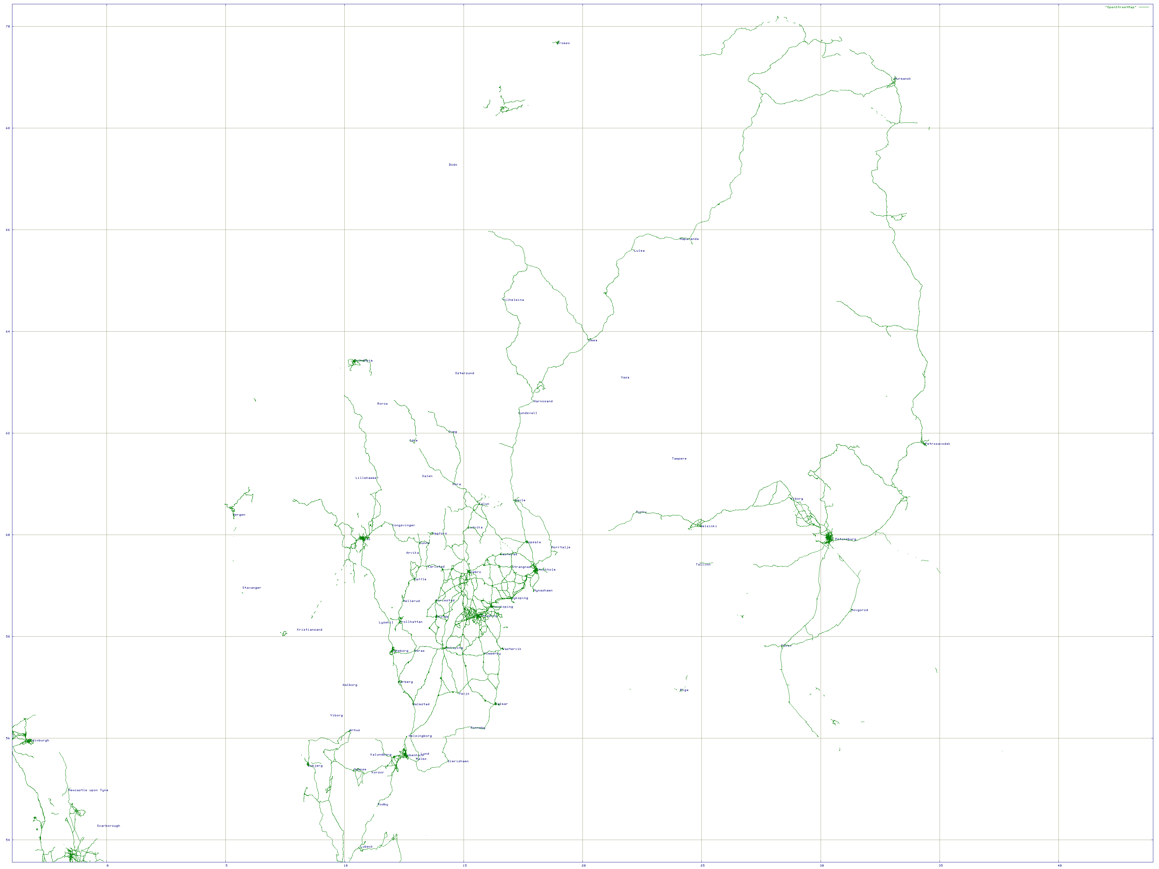
July 4, 2006: While OSM's database schema is being upgraded, I'm playing around with the new planet.osm dump and my old hack to print OpenStreetMap with Gnuplot. Using proj to fix a projection that works for Sweden, I make a map of northern Europe, neur-black.pdf, neur-color.pdf (red), neur-a2-black.pdf, neur-a2-color.pdf (blue). The supersized A2 versions are 1.3 MB, the smaller A4 versions are 569 KB. Hope the attribution is OK.
| http://aronsson.se/img/osm-200607-neur-thumb.png |
July 3, 2006: We have been supplied with a new planet.osm dump, the 3rd ever. This is great news. The map of Sweden has made great progress in the two months since the last dump. I tried to upload to this wiki a large PNG map of Scandinavia based on the dump, but this failed somehow. You can view the full resolution map but the rescaled image page seems to be broken. And after this, no image upload seems to work for me. Every image I try to upload, the Mediawiki software says "the file seems to be empty".
July 1, 2006: The ten most active map editors in June 2006 (where Ben has been importing TIGER data for the U.S.) were:
| Edits | User |
| 2033468 | ben_tiger |
| 26439 | LA2 |
| 18352 | Jörg Ostertag |
| 7286 | 80n |
| 6306 | ben_robbins |
| 6037 | johds |
| 5119 | c.morley |
| 4020 | alban.noir |
| 3359 | john.dally |
| 3311 | f_mohr |
| 3179 | rolymo |