Zh-hans:Tag:landuse=paddy
Jump to navigation
Jump to search
 |
| 说明 |
|---|
| 地表和地形适合种植水稻的农田区域。这就是 "稻田"。 |
| 组: 土地利用 |
| 用于这些元素 |
| 常用组合 |
| 另见 |
| 状态:使用中 |
| 此标签的工具 |
地表和地形适合种植水稻的农田区域。这就是 "稻田"。
如果田间种植了其他作物,如果田间状态没有改变,田间继续用于种植水稻,则仍应保留标签。
如果是在不了解地表状况、灌溉情况等的情况下种植水稻,则可以直接使用 crop=rice。例如:旱田水稻或高地水稻等。
How to map
Draw an area![]() around the boundaries of the rice paddy, and tag with
around the boundaries of the rice paddy, and tag with landuse=paddy.
Additional tags
name=*: If it's run by an agriculture-related agency or organization, it may have a name.operator=*: Indicates an agricultural operation or organization. Places run by individuals do not need to be described.irrigated=*: Used to indicate whether the paddy is irrigated or not. Typically, a wetted rice paddy might haveirrigated=yes. Anirrigated=notag can be appended to rainfed paddy fields that are not irrigated.rice:race=*: Use with the 'crop=rice' tag to indicate the geographical race of the rice. There are two main families, the 'Japonica' race(rice:race=Japonica) and the 'Indica' race(rice:race=Indica). The 'Javanica' race is included in the 'Japonica' race.
See also
surface=mud: It can be used where the condition of the land surface has been artificially made muddy.irrigated=*: It can be added to indicate that the land is dependent on irrigation.usage=irrigation: Artificial waterways which bring water to agriculture fields or facilities
Gallery
-
 Path in the countryside with trees and paddy fields, of blond color with cut rice on the left and still green on the right
 -
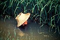
 Rice farmers harvesting rice in Gambian fields.
 -
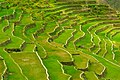
 Terraced paddy fields, Sonla, Vietnam
 -
 The Batad Rice Terraces' stairway to heaven
 -
 Two farmers driving a tractor towing a raft loaded with green rice sheaves to be planted in a paddy field
 -
 Planting the rice
 -
 Rice growing on dry land
 -
 Upland rice growing on a steep slope where forest had recently been cut and burned.
 -