Key:covered
 |
| Description |
|---|
| A property to denote if an object is covered by something. |
| Group: properties |
| Used on these elements |
| Documented values: 2 |
| Useful combination |
| See also |
|
| Status: approved |
| Tools for this tag |
|
covered=* is used to denote whether an object represented by a node, way or area is covered.
For highways and railways this differs from tunnel=* in that it is usually open at least on one side. This then implies covered=yes.
Also used in some situations where use of layer=* is not meaningful.
Usage
Use this tag for:
- Highways, footways, railways, or waterways that are (even partially) covered by a building or other structure other than where tunnel=* (including tunnel=building_passage) applies.
- Power lines, water mains, water drains, etc. in a narrow trench, with coverings traversable by traffic (foot, vehicle, or otherwise) and removable for access and maintenance.
- Buried objects other than where location=underground applies, like an area such as an underground parking lot, a covered reservoir/cistern or even such things as an aquarium (e.g., Kelly Tarlton's, Auckland, NZ), when the covering is not a man-made structure that would allow layer differentiation.
- amenity=bicycle_parking which is protected from rain.
Some mappers use this tag for:
- Highways under the area of a man_made=bridge. This is controversial, see Talk:Key:covered.
Do not use this tag for:
- Objects in tunnels (tunnel=*) where layering (layer=*) is established.
- Avalanche protectors (tunnel=avalanche_protector) even where open on one side.
- covered bridges bridge=covered).
- Where location=underground or location=underwater applies.
Tagging
Ways passing through buildings should normally have the same (or none) layer as the building.
When used this way the building and the way should have shared nodes at the entry and exit points of the building. The way should be split at the entry and exit nodes and only the part covered by the building should be tagged with covered=yes.
covered=no
Marks that an object is not covered.
covered=yes
For covered objects which are not covered by an arcade or a colonnade. This tag was approved by proposed features/covered.
The following tags are in use, but were not included in the original proposal:
covered=arcade
An arcade is a succession of arches, each counterthrusting the next, supported by columns or piers or a covered walk enclosed by a line of such arches on one or both sides.[1] Such ways should be tagged with covered=arcade. If the arcade is part of a building, the building and the way share the same node at the entry and exit points. The way is split at the entry and exit nodes and only the part covered by the building is tagged with covered=arcade The layer has to be the same as the building. So if the building doesn't have a layer tag, the way doesn't need one either. Use arcade:left=open or arcade:right=open to define which side of the way is open.
When arcade should not be used: It is not meant to be used for indoor mapping. The wall on one side is considered as an outer wall which can have entrances that lead into the building. For indoor mapping indoor=yes can be used. Also it is not meant to be used for simple roof overhangs or blind arcades.

A typical arcade in South Tyrol

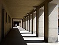
covered=colonnade
Similar to arcades, but differ architecturally, a colonnade denotes a long sequence of columns joined by their entablature, often free-standing, or part of a building.[2] Such ways should be tagged with covered=colonnade. If part of a building, the building and the way share the same node at the entry and exit points. The way is split at the entry and exit nodes and only the part covered by the building is tagged with covered=colonnade The layer has to be the same as the building. So if the building doesn't have a layer tag, the way doesn't need one either. Use colonnade:left=open or colonnade:right=open to define which side of the way is open.
When colonnade should not be used: It is not meant to be used for indoor mapping. The wall on one side is considered as an outer wall which can have entrances that lead into the building. For indoor mapping indoor=yes can be used. Also it is not meant to be used for simple roof overhangs. (In this case, "porch" might be more appropriate).
Kanslihusets arkad (misleading name; it's a colonnade, not an arcade.)

The colonnade of famous Baroque architect Gian Lorenzo Bernini in front of St Peter's in Rome


covered=partial
Some mappers use this tag to show that an object is only partially covered (e.g. by a roof), as covered=yes would mean it is full-covered or people interpret this as being full-covered. covered=partial sometimes applies to railway and other public transport platforms (e.g. railway=platform), where the platform should usually be one object (one feature, one OSM element), and when people then want to use covered=* to show that is covered in part. But if so, consider drawing another way for where the roof is and add building=roof and the suitable layer=* tag for the roof, at least additionally, or even instead.
covered=booth
This tagging is used for public telephones (amenity=telephone) which are full-covered by a phone booth with door. The tag covered=booth was chosen first to make it possible to differentiate between a full-cover booth and a roof (which would be tagged with covered=yes) and second because the tag shelter=yes does not have the same meaning. shelter=yes on an object shows that there is an amenity=shelter at this object and this is not the same as a phone booth. A phone booth is intended to cover the person who is using the phone, but it's not a shelter where several people can wait on a bus or stay protecting them from rain comfortable.
Please note that covered=booth is the above-tag for the key booth=*, which specifies the type of booth.
For tagging a phone booth which is used as a public bookcase, please use amenity=public_bookcase + public_bookcase:type=phone_box + booth=<boothtype> instead. covered=booth is not so appropriate for these, because this tag describes how a feature is covered, not the feature itself (which would be a public bookcase then). Former phone booths which are public bookcases now are the one exception where booth=* can be added without adding covered=booth before.
Examples

Additional attributes
maxheight=* may also be associated with the covered way or area to indicate clearance.
Rationale
This section changed since the approval of this feature as a result of refinement of the definition of the layer=* tag.
While using the layer or level tags is the conventional means of showing that one object is above another there are numerous situations where these tags are inappropriate and can be misleading in the context of the subsystem being mapped.
For example, when a building has a way passing through it, the building and the way through it can not be assigned distinct layers. In this situation tunnel=building_passage is used when the way has outer building walls to all sides. The tag covered=* is used when the way is open on at least one side.
A tag covered=* on the way will make routing more efficient in cases where, for example, a route to avoid the natural elements is desired, or a route to covered parking or to an area for sheltered entry or egress into a vehicle is desired.
In other cases objects can be assigned a distinct layer but can not be represented by either a bridge, tunnel, or indoor mapping - in those cases covered=* provides a simple method to express such situations.
Another use case; some objects such as underground parking garages and reservoirs are covered by an object that would not be mapped separately.
See also
- tunnel=*
- shelter=*
- building=roof
- leisure=outdoor_seating and weather_protection=*
- Proposed features/covered
- Proposed features/building passage
- Simple 3D buildings#Roof
- arcade on wikipedia
- Covered bridge on Wikipedia
Possible mapping mistakes
References
- ↑ Arcade (architecture) on Wikipedia
- ↑ Definition of "Colonnade" on Wikipedia