RU:Android
Android это операционная система для мобильных устройств, основанная на ядре Linux. Для уточнения смотрите на Wikipedia или android.com.
Информацию об Android и OpenStreetMap смотрите также the Android category, или Software/Mobilephones.
Android программы поддерживающие OpenStreetMap
OpenSource
| Name | Screenshot | Date | Shows map as bitmap | Shows map as vector | Stores map-data on-board | Navigate | Make track | License | Price | Description |
|---|---|---|---|---|---|---|---|---|---|---|
| AndNav2 [1] | 
|
2010 | да | нет | да (cache) | да | да | GPL | free | No longer actively developed, map (online/offline-"andnav_atlas_format"), routing (online) |
| AndRoad [2] | 
|
2011 | да | нет | да (cache) | да | да | GPL | free | Open-source fork of AndNav2 |
| Big Planet Tracks [3] | 2011 | да | нет | да | нет | да | GPLv3 | free | maps (online/offline-"big_planet_tracks") | |
| CycleStreets Android App [4] | 
|
2016 | да | нет | да (cache) | да | нет | GPL; | nonfreeFree | UK only |
| Geobucket [5] | 
|
2012 | ?
|
?
|
?
|
нет | да | GPL | free | Tool to make it dead simple to collect tracks and upload to Geobucket.org for tracing |
| Geopaparazzi [6] | 
|
2017 | да | да | да | да | да | GPL v3 | free | |
| GoPenS [7] | 
|
2011 | да | нет | да (cache) | да | да | GPL | free | Open source Android GPS for OpenStreetMap, map (online/offline), routing (online) |
| Gosmore [8] | 
|
2011 | нет | да | да | да | да | BSD | free | |
| GPS Logger for Android [9] | 
|
2018 | ?
|
?
|
?
|
нет | да | GPL | free | Battery efficient GPX logger. |
| GpsMid [10] | 
|
2012 | да | да | да | да | да | GPLv2 | free | very portable navi for Android and J2ME mobile phones, uses offline vector maps, audio navigation |
| GraphHopper [11] | 
|
2018 | ?
|
?
|
да | ?
|
?
|
Apache License 2.0 | free | Routing server and Android library |
| gvSIG Mini [12] | 
|
2011 | да | да | да (cache) | да | нет | GPL | free | supports WMS services, too; maps (online/offline-"custom") |
| JPSTrack [13] | 
|
2014 | ?
|
?
|
?
|
нет | да | BSD (source available) | free | Track logging for OSM w/ photo, voice, text notes |
| Keypad-Mapper 3 [14] | 2013 | ?
|
?
|
?
|
нет | да | BSD | free | highly efficient mapping of house numbers | |
| KeypadMapper2 [15] | 
|
2012 | ?
|
?
|
?
|
нет | да | BSD | free | Dedicated to housenumber mapping |
| Mapdroid [16] | 
|
?
|
да | нет | да (cache) | нет | нет | LGPL | free | Open Source proof-of-concept Android OpenStreetMap viewer. |
| Maps (-) [17] | 2010 | да | нет | да (cache) | нет | нет | Apache License 2.0 | free | Map viewer only. Caches tiles to SD card for offline viewing. | |
| Mapsforge [18] | 
|
2018 | да | да | да | нет | нет | LGPL3 | free | map application library |
| My Tracks [19] | 
|
2016 | да | нет | нет | нет | да | Apache License 2.0 | free | recording tracks (no OSM features) |
| Navit [20] | 
|
2015 | нет | да | да | да | да | GPLv2 | free | Most popular OpenSource Car navigation tool; maps (offline-"custom"), vector-rendered |
| Open GPS Tracker [21] | 2013 | да | нет | да (cache) | нет | да | GPLv3 | free | Offline GPS tracker with optional osmdroid map activity | |
| OpenFixMap [22] | 
|
2014 | ?
|
?
|
?
|
нет | нет | GPL | free | Display errors from keepright, mapdust and openstreetbugs |
| OpenSatNav [23] | 
|
2009 | да | нет | да (cache) | да | да | GPLv3 | free | Routing and recording trip; maps (online+cache); navigation (online) |
| OpenTrail [24] | 
|
2014 | нет | нет | нет | да | да | GPL | free | Freemap for Android |
| OpenTripPlanner for Android [25] | .png)
|
2017 | да | нет | нет | нет | да | Apache License v2.0 | free | An Android app for multi-modal trip planning using any OpenTripPlanner server |
| osm-android [26] | 2009 | ?
|
?
|
?
|
нет | да | GPLv3 | free | renders OpenStreetMap maps and calculates routes | |
| OsmAnd [27] | 
|
2018 | да | да | да | да | да | GPL v3 | nonfreefree or 5.99€ | |
| OSMBugs [28] | 
|
2017 | ?
|
?
|
?
|
нет | нет | GPL | free | Display and edit Bugs from Notes, Keepright and Mapdust |
| osmdroid [29] | 
|
2017 | да | нет | да | нет | нет | Apache License 2.0 | free | Replaces GMaps views; maps (online/offline-"andnav2") |
| OsmSharp [30] | 
|
2016 | ?
|
?
|
?
|
?
|
?
|
GPLv3 | free | OSM routing and optimisation library. |
| OSMTracker for Android [31] | 2018 | да | нет | да (cache) | нет | да | GPLv3 | free | Offline GPS tracker with fast POI placement shortcuts. Exports in GPX format with waypoints, suitable for editing in JOSM. Clone of OSMtracker (Windows Mobile) | |
| RMaps [32] | 
|
2013 | да | нет | да | нет | да | GPL | free | Maps and a compass, maps (online/offline-"rmaps") |
| RTKLIB [33] | 
|
2015 | ?
|
?
|
?
|
?
|
?
|
Free | free | Open source program package for GNSS positioning |
| ShareNav [34] | 
|
2012 | да | да | да | да | да | GPLv2 | nonfree€2.99 on Google Play Store (may vary depending on local taxes) | very portable navi for Android&J2ME mobile phones, uses offline vector maps, audio navigation |
| Track@Way [35] | 
|
2014 | да | нет | да | да | да | GPL | free | A fast and easy to use map and tracking software. Ability to export tracks in GPX including your recorded POIs. Different maps to choose (OSM, Mapquest etc.). Many options and a support forum. |
| Vespucci [36] | 
|
2018 | да | да | да (cache) | нет | да | Apache license 2.0 | free | OSM editor |
| ZANavi [37] | 
|
2016 | нет | да | да | да | нет | GPL | free | Offline Navigation System for Android |

This table in the past was generated automatically by a bot. Learn more.
Free
| Name | Screenshot | Shows map as bitmap | Shows map as vector | Stores map-data on-board | Navigate | Make track | License | Price | Description |
|---|---|---|---|---|---|---|---|---|---|
| Ape@map [38] | 
|
да | нет | да (cache) | нет | да | nonfreeproprietary | free | |
| BikeAtor [39] | 
|
да | нет | да | нет | да | nonfreeproprietary | free | Show Maps, Caches, Speedometer, log GPX... |
| Compass Navigator 3D [40] | 
|
?
|
?
|
?
|
да | нет | nonfreeproprietary | free | 3D compass with a GPS navigation "arrow". Line-of-sight-navigation to OSM POIs and addresses. |
| Cruiser [41] | 
|
да | да | да | да | нет | nonfreeproprietary | free | Cruiser is an Android map and navigation application using offline vector maps. |
| inViu routes [http://ENAiKOON GmbH] | да | нет | да (cache) | да | да | nonfreeproprietary | free | GPS swiss knife | |
| Layar Reality Browser | нет | да | нет | нет | нет | nonfreeproprietary | free | Augmented Reality browser mixes camera image with virtual reality | |
| LockOnMe [42] | 
|
да | да | нет | нет | нет | nonfreeproprietary | free | Location-sharing app, displaying targets and/or associated Points Of Interest on OSM & fun radars |
| MapDroyd [43] | 
|
нет | да | да | нет | нет | nonfreeproprietary | free | Offline vector map viewer for Android. Compact one-off data downloads |
| mapFactor Navigator free [44] | 
|
нет | да | да | да | да | nonfreeproprietary | free | professional framework for OSM-based car navigation |
| MapQuest [45] | нет | нет | нет | нет | нет | nonfreeproprietary | free | ||
| OSMapTuner [46] | 
|
нет | да | да (cache) | нет | нет | nonfreeproprietary | free | Simple editor for manipulating tags on your smartphone |
This table in the past was generated automatically by a bot. Learn more.
Full version non free
| Name | Screenshot | Shows map as bitmap | Shows map as vector | Stores map-data on-board | Navigate | Make track | License | Price | Description |
|---|---|---|---|---|---|---|---|---|---|
| AFTrack GPS-Tracking [47] | 
|
да | нет | да | да | да | nonfreeproprietary | nonfree3.90€;4.95$;free | Offline navigation with many map formats - BSB3 (*.kap), NV-digital (*.eap), Bitmaps with calibration file (format: map, gmi, kml, kal, cal, pwm), OSZ (zipped osm tile collection), mbtiles, sqlitedb, Mapsforge vector format and online maps |
| AlpineQuest GPS Hiking [48] | 
|
да | нет | да | нет | да | nonfreeproprietary | nonfree3€ | Orienteering focused |
| BackCountry Navigator [49] | 
|
?
|
?
|
да | да | да | nonfreeproprietary | nonfree9.99$ (fully functional time limited free demo available) | Hiking focused. Many map formats available; including OpenStreetMaps, NASA landsat, MyTopo.com topo maps of US and Canada, OpenCycleMaps showing terrain worldwide, USGS Color Aerial photography, UK Ordinance Survey Explorer Maps, Topographic Maps of Spain and Italy, Topo maps of New Zealand. |
| be-on-road [50] | 
|
нет | да | да | да | да | nonfreeproprietary | nonfreeFree | Offline multi-language voice navigation app with lane-guidance assistant. Data from OSM and propietary maps. |
| BikeCityGuide http://getfinn.com/ | 
|
нет | да | да | да | да | nonfreeproprietary | nonfree5Eur per city | Designed for cyclists in urban areas incl. Insider tours. |
| City Maps 2Go [51] | 
|
да | да | да | нет | нет | nonfreeproprietary | nonfreeiPhone: 2.99$ / 2.69€ Android: free | City Maps 2Go |
| ForeverMap [52] | 
|
нет | да | да | да | нет | nonfreeproprietary | nonfreeiPhone: 1,59€, Android: 1,59€ (Free Android version available) | ForeverMap is an offline navigation app, providing address/POI search and route calculation |
| Gaia GPS [53] | 
|
да | нет | да (cache) | да | да | nonfreeproprietary | nonfree19.99$ iOS / $9.99 Android | hiking focused logger |
| MAPS.ME [54] | 
|
нет | да | да | нет | нет | nonfreeproprietary | nonfreeFree/$4.99 for Pro | Offline maps of all countries, fast renderer, offline search, whole planet fits to 12Gb |
| NavDroyd [55] | 
|
нет | да | да | да | нет | nonfreeproprietary | nonfree5€ | |
| NavFree [56] | 
|
нет | да | да (cache) | да | нет | nonfreeproprietary | nonfreeFor Android is free. For iOS the first country is free, then €2.69. | Free satnav app. Maps available: Andorra, Argentina, Australia, Austria, Benelux (Belgium, Netherlands, Luxembourg), Brazil, Canada, Croatia, Czech Republic, Denmark, Estonia, Finland, France, Germany, Hungary, India, Ireland, Italy, Latvia, Lithuania, Mexico, Monaco, Netherlands, New Zealand, Norway, Poland, Portugal, Slovakia, Slovenia, South Africa, Spain, Sweden, Switzerland, UK. |
| Navitel [57] | 
|
нет | да | да | да | да | nonfreeproprietary | nonfree17€ | Popular in Russia |
| ОРУ-карты [58] | 
|
да | да | нет | да | нет | nonfreeproprietary | free to try, ca. 5$ | OpenStreetMap 3D on Android |
| Run.GPS [59] | да | нет | да (cache) | нет | да | nonfreeproprietary | nonfree20€ | Sport focused logger | |
| Skobbler GPS Navigation [60] | 
|
нет | да | да | да | нет | nonfreeproprietary | nonfreeAndroid: €1.00, free Version available (no offline maps); iOS: €1.79 | Online and offline worldwide turn-by-turn navigation. Includes pedestrian and cyclist route planner, TripAdvisor, Foursquare and speed camera warning integration. |
| TravelDroyd [61] | 
|
нет | да | да | нет | нет | nonfreeproprietary | nonfree5€+books | Combining offline OSM+wikipedia articles for travelguides that you have to buy |
| Vectorial Map [62] | 
|
да | да | да | нет | да | nonfreeproprietary | nonfreedepends on platform | Vectorial Map is map viewer and track logger for Mapsforge offline vector maps (*.map) with support for custom XML styles like provided by OpenAndroMaps.org. It is based on a platform independent custom render engine. |
| VGPS [63] | 
|
нет | да | да | да | нет | nonfreeproprietary | nonfree5$ | OSM and Garmin offline map with routing turn-by-turn navigation for Android and J2ME mobile phones |
| Wisepilot [64] | 
|
да | да | нет | да | нет | nonfreeproprietary | nonfree€1.79 monthly | online turn-by-turn navigation |
This table in the past was generated automatically by a bot. Learn more.
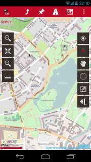
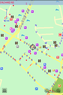
Images
- OSM on Android
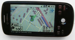
AndNav2 routing on HTC Magic
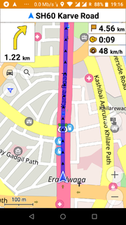
OsmAnd routing
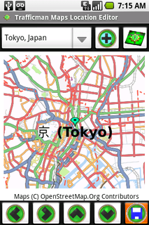
Trafficman Maps 1.0
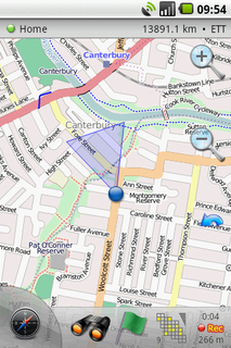
Maverick 1.1.7
Oruxmaps v2.3.4beta with HikeBike Map in Track Logging Mode
VGPS v5.2 is runing on Android


Videos:
- OpenStreetMap, from the Kabul Airport to Jalalabad - Describes OSM in general and using MapDroyd to view maps.
Android specifics in other pages
Accessibility
- "Eyes free" - How to make programs accessible for the blind.
- Android accessibility.
General
There are a number of projects on Google Code with both 'android' and 'openstreetmap' tags: Search Google Code.
MGMaps Lib (Nutiteq???s Android libraries)