Community Updates/2011-02-14
Community Update from 14 February 2011 to 20 February 2011 (week 2011-07)
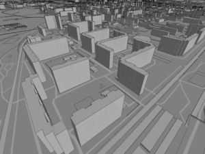
Image Of the Week 2011-07glosm is a hardware-accelerated OpenGL-based OpenStreetMap renderer, producing 3D renderings like this one of an area of Moscow |
Project Of The Week : Food Bank
Sometimes we map for ourselves, other times we can map for others. The Project of the Week is to add local food banks to the map.
News Of The Week
- The 100.000.000th way
- BroadBand Map is using OSM
- Nice visualisation of contributions [1]
- user:Harry Wood has a talk on the Being Open in London
- Do you already know http://www.satsentinel.org ? Using Google Maps Maker to monitor the Sudan crisis (if I understood it correctly)
- A new import in Georgia JumpStart Import
- MapQuest asks for presenting projects that use their Open stuff at the SXSW conference [2]
Software updates
- HOT needs help in mapping Libya and Bahrain [3]
- Release of GpxSplitter
- Mapquest release an Android app [4]
- New version of CartOSM, an easy point and publish for your website
- A new plug-in for JOSM that visualises in 3D [5]
- JOSM now supports MapCSS style sheets
- developerseed announces TileMill, a web based Mapnik front-end [6]
- A German trekking journeys provider offers it's GPS tracks to OSM [7]
Mountain Pass, on ways ?
In the wiki, mountain passes are define with the tag mountain_pass=yes, and it says "As passes only make sense on ways it should be in the highway section".
But some passes are not specially on ways and this definition is problematic with dual carriageways.
Draft: Vegetarian and special diets
Here is a new proposition to tag special diets. The author was not satisfied by the old cuisine=vegetarian so he made a new proposition.
This proposition handle different diets like vegan, raw fooding, ovo vegetarian, ... inside a diet:*=yes/no/only.
As usual, please make your comments on the talk page.
Underground and hovering buildings
I told you last week that 3D is heavily debated in OSM, this week again some related topics show up. The problem of hoovering and multi-level buildings is hard to handle in a 2D world. Contributors show great ingenuity to handle these kinds of problems in the current OSM model.
True Offset Web Service
Sometimes aerial imagery provide a great tool to add information into OSM, but sometimes, the images are not well positioned and can have an offset of several meters. This service wants to share the offset for an imagery between contributors.
Check the True_Offset_Process page for more info.
Thanks
Big thanks to !i! for the help

