Featured images/Jul-Sep 2014
Jump to navigation
Jump to search


These are featured images, which have been identified as the best examples of OpenStreetMap mapping, or as useful illustrations of the OpenStreetMap project.
If you know another image of similar quality, you can nominate it on Featured image proposals.
| ← from July to September 2013 | ← from April to June 2014 | from October to December 2014 → | from July to September 2015 → |
Gallery of featured images, from July to September 2014
-
2014, week 27
-
 2014, week 28
 -
 2014, week 29
 -
 2014, week 30
 -
 2014, week 31
 -
 2014, week 32
 -
2014, week 33
-
 2014, week 34
 -
 2014, week 35
 -
 2014, week 36
 -
 2014, week 37
 -
 2014, week 38
 -
 2014, week 39
Details and captions
Week 27 (from Monday 30 June 2014 to Sunday 6 July 2014) [Edit]

- English : This striking pop-art style image was created by @leopardengruen using OpenStreetMap data from Karlsruhe. It took 4th place in the SOTMEU poster competition
Week 28 (from Monday 7 July 2014 to Sunday 13 July 2014) [Edit]

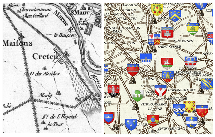
- English : Frédéric Rodrigo developed a stylisation of OpenStreetMap data designed to mimic the classic 18th century french maps by Cassini (shown on the left). You can browse a full map of France in this style, on a site developed for the Heraldry wikipedia project. Frédéric also won 3rd place in the SOTMEU poster competition with a poster-sized print of this map
Week 29 (from Monday 14 July 2014 to Sunday 20 July 2014) [Edit]

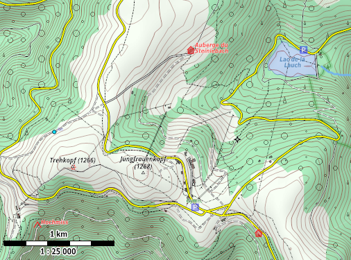
- English : A sample area rendered in the R25 Maperitive style, which was designed by User:JBacc. It works best rendering hi resolution paper maps at approximately 1:25000 map scale, as he demonstrated with his entry coming 2nd place in the SOTMEU poster competition
Week 30 (from Monday 21 July 2014 to Sunday 27 July 2014) [Edit]

- English : 3D printed model of the Gorbals, Glasgow, location of the Commonwealth games 2014. Created using osm2world to convert from .osm to 3D and SRTM elevation data. Printed using a Ultimaker 2.
Week 31 (from Monday 28 July 2014 to Sunday 3 August 2014) [Edit]
- English : This poster by the Fukushima, Japan, OpenStreetMap community was the winner of the SOTMEU poster competition,(download as PDF)
Week 32 (from Monday 4 August 2014 to Sunday 10 August 2014) [Edit]

- English : Mapping for fun, and to help with humanitarian aid at the Missing Maps Party in London last week
Week 33 (from Monday 11 August 2014 to Sunday 17 August 2014) [Edit]

- English : Last weekend we celebrated OpenStreetMap's 10th Birthday in cities all around the world, and (as is now traditional) we had birthday cakes at many of the party locations, such as this one in Passau, Germany
Week 34 (from Monday 18 August 2014 to Sunday 24 August 2014) [Edit]

- English : Cake is good. And so are map tiles. Toronto mappers made coasters from maps and ceramic tiles. The coasters safely supported the beverages consumed at the Toronto 10th OSM Birthday celebration, and then attendees were each able to take home the commemorative coasters in addition to the ones that they made.
Week 35 (from Monday 25 August 2014 to Sunday 31 August 2014) [Edit]

- English : Malawi government officials learning how to create maps with OpenStreetMap. The Humanitarian OpenStreetMap Team have sent a field team to Malawi to run training courses in mapping techniques and also integrating OpenStreetMap into their open GIS data portal. Read more on the HOT blog
Week 36 (from Monday 1 September 2014 to Sunday 7 September 2014) [Edit]

- English : Printed street maps from OpenStreetMap seen in several bus stops around Bishkek, the capital of Kyrgyzstan
Week 37 (from Monday 8 September 2014 to Sunday 14 September 2014) [Edit]

- English : About two dozen women participated in a "Girl’s Mapping Party" organised by Kathmandu Living Labs in Nepal/Kathmandu. Read more on the blog
Week 38 (from Monday 15 September 2014 to Sunday 21 September 2014) [Edit]

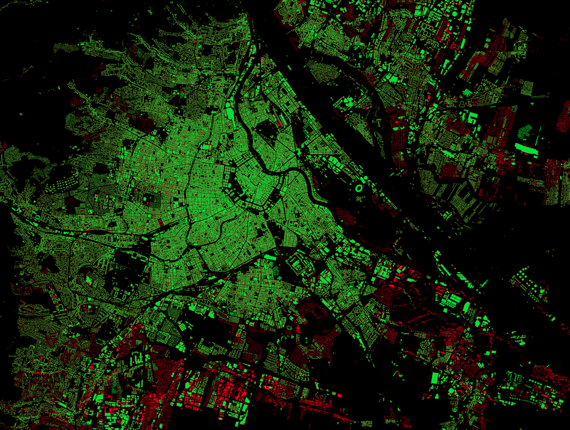
- English : A striking dark-background rendering of OpenStreetMap building coverage (green) and those which are missing (red) as compared to basemap.at data in Austria. Blog post and slippy map
Week 39 (from Monday 22 September 2014 to Sunday 28 September 2014) [Edit]

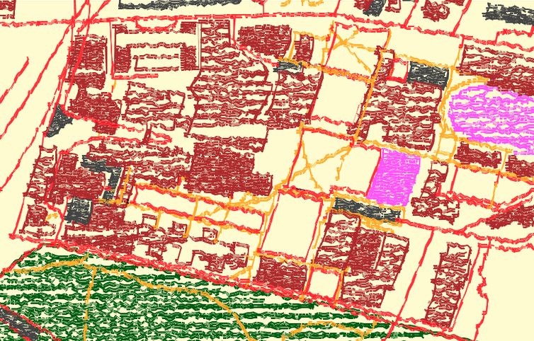
- English : The OpenStreetMap Crayon Style. Browse a slippy map here. This playful use of map data is rendered with JavaScript and HTML5 canvas. source and more details