Featured images/Jul-Sep 2016
Jump to navigation
Jump to search


These are featured images, which have been identified as the best examples of OpenStreetMap mapping, or as useful illustrations of the OpenStreetMap project.
If you know another image of similar quality, you can nominate it on Featured image proposals.
| ← from July to September 2015 | ← from April to June 2016 | from October to December 2016 → | from July to September 2017 → |
Gallery of featured images, from July to September 2016
-
2016, week 27
-
 2016, week 28
 -
 2016, week 29
 -
 2016, week 30
 -
 2016, week 31
 -
 2016, week 32
 -
 2016, week 33
 -
2016, week 34
-
2016, week 35
-
2016, week 36
-
 2016, week 37
 -
 2016, week 38
 -
 2016, week 39
Details and captions
Week 27 (from Monday 4 July 2016 to Sunday 10 July 2016) [Edit]

- English : Board game using OSM data: memory game of the French largest cathedrals. JBacc created this by filtering of the Geofabrik extract with Osmosis, area calculation with QGIS, data processing and rendering with Maperitive/Maperipy.
Week 28 (from Monday 11 July 2016 to Sunday 17 July 2016) [Edit]

- English : Luc Freitas analysed mapping progress of Brazilian cities (diary entry in Portuguese). He looked at the size of cities based on municipal boundaries data (already imported from IBGE), and correlated this with the amount of residential roads data in OpenStreetMap. This image and the tabular output helps guide further mapping efforts by the Brazilian community.
Week 29 (from Monday 18 July 2016 to Sunday 24 July 2016) [Edit]

- English : Throughout June there was a big series of MapLesotho mapping events (involving modem equipment travelling around the country!), culminating in this final mapping session with a visit from the Lesotho minister for local government. Read more on the MapLesotho blog.
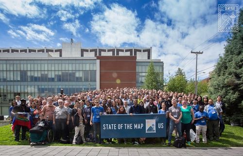
Week 30 (from Monday 25 July 2016 to Sunday 31 July 2016) [Edit]

- English : State Of The Map U.S. 2016 took place last weekend in Seattle with a packed program of talks, workshops, hacking & mapping.
Week 31 (from Monday 1 August 2016 to Sunday 7 August 2016) [Edit]

- English : In Bluefields, Nicaragua, the local OSM community and UNICEF worked with school children to help them empower themselves through the use of maps.
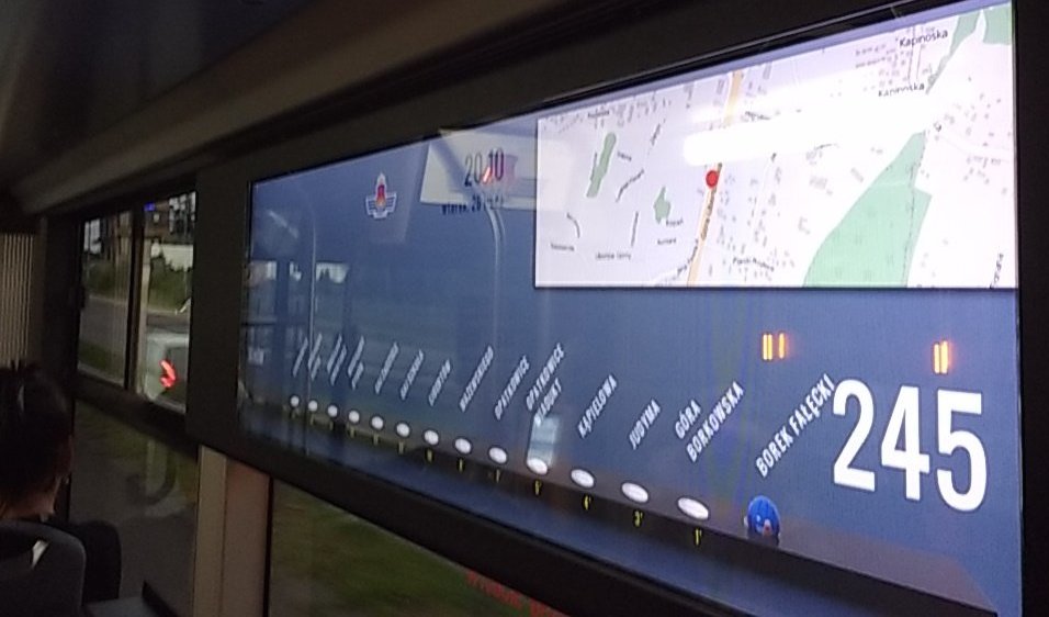
Week 32 (from Monday 8 August 2016 to Sunday 14 August 2016) [Edit]

- English : OpenStreetMap spotted on board a bus in Kraków, Poland.
Week 33 (from Monday 15 August 2016 to Sunday 21 August 2016) [Edit]

- English : State of the Map Japan 2016 was held in Tokyo last week.
Week 34 (from Monday 22 August 2016 to Sunday 28 August 2016) [Edit]

- English : The ByKy bike share system in Dubai (UAE) has signposts at each docking station, featuring OpenStreetMap!
Week 35 (from Monday 29 August 2016 to Sunday 4 September 2016) [Edit]

- English : The OpenStreetMap 12th Anniversary Birthday party was celebrated around the world, including cake in Japan, India and Germany!
Week 36 (from Monday 5 September 2016 to Sunday 11 September 2016) [Edit]

- English : A spiderweb of streets around the Plaza del Ejecutivo, in Mexico City.
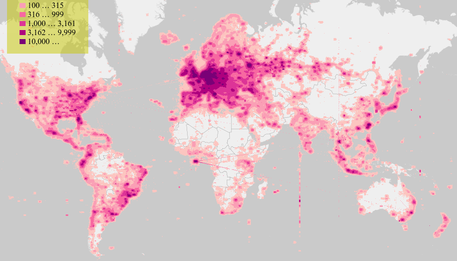
Week 37 (from Monday 12 September 2016 to Sunday 18 September 2016) [Edit]

- English : Visualising tool created by the Martin Raifer allows us to explore the stats about OpenStreetMap.org map views. Read more on his diary.
Week 38 (from Monday 19 September 2016 to Sunday 25 September 2016) [Edit]

- English : A collaborative emergency mapping event organized by the Wikimedia and OpenStreetMap communities in the City of Trento, Italy.
Week 39 (from Monday 26 September 2016 to Sunday 2 October 2016) [Edit]

- English : Group photo at the international OpenStreetMap conference State Of The Map 2016 in Brussels.