Key:height
 |
| Description |
|---|
| Height is the measurement of vertical distance. It indicates how "tall" something is. |
| Group: properties |
| Used on these elements |
| Useful combination |
| See also |
| Status: de facto |
| Tools for this tag |
|
The key height=* describes the actual height of a feature.
Tagging
Units
The default unit is metres. If the height is measured in a different unit, the unit abbreviation is appended to the value, separated by a space (except for feet/inch). See the examples below or the unit specification article for more information. For height values with decimal places, use the period character as decimal separator.
Sources
The source of the height information can be specified by source:height=*.
The accuracy of the height information can be specified by height:accuracy=*.
Examples
Here are a few examples of how a height can be tagged.
| Height | Tagging | Remark |
|---|---|---|
| Four metres | height=4
|
Specifying the units is optional for metres, and would look like: height=4 m.
|
| 1.35 metres | height=1.35
|
Use the decimal / full stop / period character as a separator. |
| 7 feet and 4 inches | height=7'4"
|
Use a typewriter apostrophe character after the feet value and a typewriter double-quote character after the inches value. Spaces are not permitted. |
Height of buildings


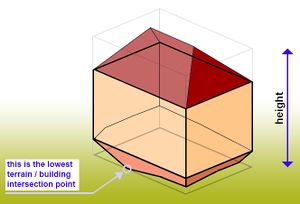
Use the maximum height for buildings, not the average height. Specifically, the maximum is the distance between the top edge of the building (including the roof, but excluding antennas, spires and other equipment mounted on the roof) and the lowest point at the bottom where the building meets the terrain.
Building parts
The height of individual parts of buildings uses the same tag, see the Simple 3D buildings specification for more details.
Potential issues
Elevation above mean sea level
The ![]() elevation above mean sea level for objects in OpenStreetMap is not specified using the
elevation above mean sea level for objects in OpenStreetMap is not specified using the height key. Objects using this type of measurement should use the ele=* key. For example, a mountain peak with the natural=peak tag uses the ele=* key to specify the highest point on the peak.
Restricted height
Height restrictions, such as the vertical clearance under a bridge or through a tunnel are not tagged using the height key. Use the maxheight=* key to specify the maximum height allowed, or maxheight:physical=* for the highest physically possible clearance.
Hunting stands in German-speaking countries
As of 2023-07, there are over 3,000 amenity=hunting_stand that are tagged with height=full/half/low. Nearly all of these are in German-speaking countries.[1]
Incorrect values
The following table contains examples of incorrect tags and their correct notation, which are commonly misused.
| Incorrect | Explanation | Correct |
|---|---|---|
height=4m
|
The space between value and unit is missing. | height=4 or
|
height=0,8
|
The comma is used as wrong decimal separator. | height=0.8 or
|
height=11' 4"
|
There should not be a space between feet and inches. | height=11'4"
|
See also
source:height=*– Source of the object heightmin_height=*– Height of location of bottom part of building, part of building or another objectminimum_height_requirement=*– A person's height must be greater than this to use a feature, e.g. a roller coaster or a fitness stationbuilding:levels=*– The number of above ground levels in a building, not including the levels in the roof and in the basementbuilding:min_level=*– For describing number of values "filling" space between ground level and bottom level of building or part of building- Overview of possible units
- Specification of the elevation above mean sea level via
ele=* - Specification of the maximum permissible height of vehicles via
maxheight=* - Specification of the width via
width=* - Specification of the length via
length=* - Specification of the depth of a water feature (lake, river...) via
depth=* - Specification of a distance via
distance=*