Proposal:Trailhead
|
The proposal trailhead was built without a vote and the tagging is widely established based on this proposal. The Feature Page for the proposal trailhead is located at Tag:highway=trailhead. |
| Proposal status: | Proposed (under way) |
|---|---|
| Proposed by: | Pelderson |
| Tagging: | highway=trailhead
|
| Applies to: | |
| Definition: | A designated or customary place where a trip on a trail begins or ends. |
| Statistics: |
|
| Rendered as: | |
| Draft started: | 2015-04-11 |
| RFC start: | 2023-02-23 |
[[Category:Proposals with "Proposed" status|]][[Category:Proposed features under way|]]
Proposal
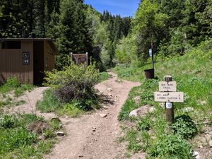
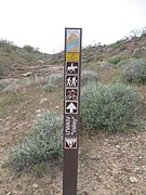
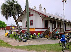
A trailhead is a designated or customary place where people can stop or start a trip on one or more trails or routes. Its position may be marked by a shelter, pole, special design, flag, banner, or parking area. Often there will be a board with a name and a reference to an operator. Parking space will usually be available. Some trailheads are unmarked and known only by word-of-mouth or from information provided on a list or website. The highway=trailhead tag is used on a node or a closed way to identify the position where people prepare to start their trip.

Rationale
Trailheads are points-of-interest that help designate well-established places to start or end a trip. If mapped in OSM, a start of a path marked as highway=trailhead would differentiate it from other path/road junctions that may not be suitable recreation starting points. Additionally, a trailhead designation would help further advertise the existence of an established recreational trail network.
Applies to
The tag is primarily used for a node representing the trailhead. The node is often attached to a way that is part of the route or routes. Some mappers also include the trailhead node in the route relation. Some mappers apply the tag to a closed way representing the outline of the trailhead. Some mappers tag an already mapped area (e.g. a parking) as highway=trailhead.
How to map
Basic Trailhead node
A trailhead node (example on the map) is placed at a location visibly designated or customary for starting a trip on a waymarked route. It is up to the mapper to decide the exact location: it may coincide with a board or guidepost, or maybe a gate or a pole, or a corner of a parking area. Some mappers apply the tag to a closed way tracing the outline of the trailhead.
Tagging
| Tag | Usage | Description |
|---|---|---|
highway=trailhead |
! Required | This tag is used on a node (or a closed way) representing the place where people are supposed to or used to start their trip on a trail, track or route. |
name=* |
‽ Important | If exists, specific name of the trailhead as indicated or customary |
operator=* |
? Optional | Name of the operator if exists. |
Additional tagging
As trailheads vary widely across the globe, it is up to local mappers and communities to decide on additional tagging on the node or way itself and the amenities or facilities which may accompany the trailhead, such as parking area, benches, banner, information board, map board, trail register, toilets, guidepost(s), shelter, ...
Associated attributes or features may be represented by additional tags applied to a trailhead node (or area), or on a separate objects, possibly as part of a relation depending on the how the trailhead is modeled.
Appropriate tags may include:
name=*if the trailhead has a common nameamenity=toiletsortoilets=yes/noamenity=drinking_waterordrinking_water=yes/noamenity=bicycle_parkingorbicycle_parking=*information=boardinformation=guidepostbarrier=*access=*(including conditional restrictions)
Examples
Observable trailheads are frequently present on trails found in regional or national parks. Park authorities such as the U.S. National Park Service maintain a database called Places in which employees can add/edit trailheads and other points-of-interest located in national parks.
Photos
Rendering
Trailheads could be rendered using a symbol modeled after ![]() , an icon from the NPMaps Places collection. Or a variation on the guidepost symbol, or a gate-like symbol
, an icon from the NPMaps Places collection. Or a variation on the guidepost symbol, or a gate-like symbol ![]()
Features/Pages affected
This tag is an established tag. Approving it will only affect the status of the tag.
Pages affected:
- Key:Highway (Other Features) (status will change from de facto to approved)
- Translation pages of Tag:highway=trailhead
External discussions
- https://community.openstreetmap.org/t/highway-trailhead-from-in-use-to-approved/9186
- https://lists.openstreetmap.org/pipermail/tagging/2023-February/067040.html
- https://lists.openstreetmap.org/pipermail/tagging/2018-December/041581.html
- https://lists.openstreetmap.org/pipermail/tagging/2015-April/023797.html
Comments
Please use discussion page to comment.


