Tag:amenity=drinking_water
 |
| Description |
|---|
| A drinking water source which provides potable water for consumption. |
| Rendering in OSM Carto |
| Group: amenities |
| Used on these elements |
| Implies |
|
| Useful combination |
| See also |
| Status: approved |
| Tools for this tag |
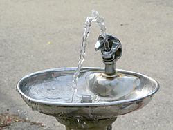
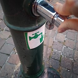
Drinking water is a place where humans can obtain potable water for consumption. Typically, the water is used for drinking. This includes ![]() drinking fountains or bubblers, water taps, water wells, springs and water points. Generally, this feature provides small quantities of water.
drinking fountains or bubblers, water taps, water wells, springs and water points. Generally, this feature provides small quantities of water.
Where drinking water is provided in large quantities, use amenity=water_point or waterway=water_point; i.e., for refilling tanks in motorhomes, boats, etc.
How to map
Add amenity=drinking_water to an existing element or create a new one.
Usually these features are open to the general public without access restrictions or fees. Thus, not every water taps in private houses shall be mapped – drinkable water from a water supply network is not a valid reason to map amenity=drinking water in every house connected to it.
Useful combinations
name=*– The main name if applicable; e.g. prominently signposted.operator=*– The operator.bottle=yes– If the feature offers an easy way to fill a portable water container.drinking_water:refill=yes– If an establishment (café, bar, etc.) participates in a water refill network – indicated by a visible sticker or sign – so you can refill a bottle free of charge.cold_water=yes/no,warm_water=yes,hot_water=yes/no– The water temperature.capacity=*– Indicates how many people can use the feature at the same time.indoor=*– Indicates whether the feature is located indoor or outdoor.historic=yes– Indicates the historic significance of the feature.fountain=*– Indicates subtype and partly also style of the structure that provides drinkable water.fountain=bubbler– A fountain which provides a small jet of drinking water (also sometimes mapped asman_made=drinking_fountain).seasonal=yes– If turned off or removed for winter.dog=designated– Indicates that there is a separate bowl and water dispenser for dogs. These are typically located low on an outdoor drinking fountain, accessible to dogs.wikimedia_commons=*- a picture of the specific feature is always helpful, take a photo of every fountain and upload it to wikimedia commons, then link it with this tag. Or use a different hoster and link it withimage=*.
Nonworking features
It is advised to apply lifecycle tagging, i.e. you add a prefix like "disused:" or "abandoned:" to the main key (amenity). This tagging will likely remove them from most maps.
disused:amenity=drinking_waterfor features that are not active or require only minor repair.abandoned:amenity=drinking_waterabandoned features, these would require extensive repair. Often these have been left for some time as 'disused' before falling to 'abandoned'.
Alternative tagging
The tag drinking_water=* is used as an indication whether a physical feature provides potable water. For example a public toilet may provide drinking water, but this is not the primary purpose, thus amenity=toilets + drinking_water=yes is more appropriate than amenity=drinking_water, similarly, there are amenity=fountain, amenity=watering_place, natural=spring and others, which are often used in conjunction with drinking_water=*. In order to map on a fine level of granularity, it is also acceptable to mark the individual water sources as a amenity=drinking_water, e.g. within a bigger building.
Photo examples
Other examples:
-
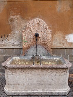
A historical drinking fountain, Trento, Italy
-
One of the fountains in Loriga, Portugal
-
Multi-use drinking fountain with bottle filling station and fountain for dogs, Athens, Georgia
-
drinking water point at a
amenity=sanitary_dump_station
Proposal history
- Proposal:Potable Water – original proposal.
- Proposal:Water network
- Proposal:Drinking water attributes – proposal for extension of tagging
External links
- www.wetap.org – iOS applications (Android coming soon, it says) for collecting drinking water photos/locations/status.
- OSMBright-drinkingwater – Files to make the OSMBright theme for OpenStreetMap show drinking water more prominently.
Common/possible tagging mistakes
See also
man_made=water_tap– A public access point to a centralized water distribution system, containing a valve activated by the user (it may or may not provide drinking water).man_made=water_tap+drinking_water=no– For publicly accessible water taps supplying water that is not drinkable; e.g. on cemeteries for watering plants and washing graves.amenity=water_point– A place to get larger amounts of drinking water for filling a fresh water holding tank, usually for caravans, mobile homes/RVs, or boats.waterway=water_point– A specific tag for a place to get larger amounts of drinking water for boats (for example, this tag is extensively used on the UK canal system).amenity=watering_place– A place where animals drink water.amenity=fountain– A fountain for cultural, decoration and/or recreational purposes, and refined byfountain=*to define subtypes and sometimes also styles.shop=water– For shops that sell water. Note thatamenity=drinking_water, which implies no-fee access to water, is not appropriate for these shops.vending=water- selling water viaamenity=vending_machineman_made=water_well– A man made excavation in the ground to gain water from an aquifer andpump=*can be used to describe how the water is drawn.natural=spring– Indicates water flowing naturally out of the ground.emergency=drinking_water- A facility that provides drinking water in emergency situations; water might need pre-treatment to be safe to drink.- Proposal:Village Pump – For the central, prominent pump of a village – often a landmark.


