Tag:amenity=biergarten
 |
| Description |
|---|
| An open-air area where beer is served and you are allowed to bring your own food. |
| Rendering in OSM Carto |
| Group: Food and beverages |
| Used on these elements |
| Useful combination |
|
| See also |
| Status: unsupported “defacto” status |
| Tools for this tag |
|
[[Category:Tag descriptions with status "unsupported “defacto” status"|amenity biergarten]]
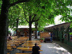
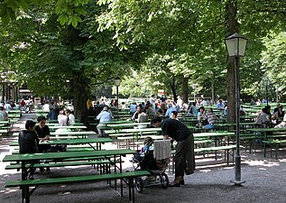
A ![]() biergarten or beer garden is an open-air area with benches where beer (and other beverages) is served. Food may be served, but you are allowed to bring your own food. They originate in Bavaria (Southern Germany).
biergarten or beer garden is an open-air area with benches where beer (and other beverages) is served. Food may be served, but you are allowed to bring your own food. They originate in Bavaria (Southern Germany).
To be clear, a biergarten is not the same as (what is known in the UK as) a "beer garden", i.e., an outside area associated with a pub. These are not biergartens in the Bavarian sense and may be tagged as a beer_garden or by adding outdoor_seating=* to the pub, cafe or restaurant.
How to map
Set a node at the center of the feature or draw an area along its outline.
Tag it with amenity=biergarten.
Add name using name=* or use noname=yes to mark that object has no name.
Useful combination
Use these possible tags to expand the feature further.
- cuisine=* - The cuisine tag is for the type of food served.
- capacity=* - The capacity tag is for indicting the volume of people allowed.
- brewery=* - The brewery tag is for a location name that sells beer from a brewery.
To map further about a specific biergarten here are some examples.
- addr=* - The addr tag is the prefix for several addr:* keys to describe the address of a biergarten.
- operator=* - The operator tag is used to name a company, corporation, person or any other entity who is in charge of the operation of a biergarten.
- ref:vatin=* - The ref:vatin is a tag to add the VAT identification number to a biergarten. See the wikipedia page about
![[W]](/w/images/2/24/Wikipedia-16px.png "Wikipedia") VAT identification numbers.
VAT identification numbers. - opening_hours=* - The opening hours tag describes the hours when the biergarten is open or closed.
- wikipedia=* - The wikipedia tag provides a link to Wikipedia's article about the biergarten.
- phone=* - The phone tag is for a telephone number associated with the biergarten.
See also
The term biergarten originates from Bavaria.[1] See the wikipedia page ![]() beer garden for more information about the history of a biergarten.
beer garden for more information about the history of a biergarten.
Rendering
| Standard tile layer | |
|---|---|
| Map Icon | |
| Example on the map |  |
Photo examples

Biergarten Hofbräukeller in München
Deutsch: Hofbräukeller München, Arkaden nebst dem Biergarten

Olympic Club Hotel (a.k.a. Olympic Club Saloon), 112 N. Tower St., Centralia, Washington, listed on the National Register of Historic Places. Rear view (outdoor dining, beer garden).

Beer garden, Leavenworth, Washington.

Biergarten der Kugler Alm.
Englischer Garten, München (Munich), Deutschland (Germany)

Deutsch: Westpark München; Biergarten „Hopfengarten“ im Oktober.

.jpg)


Footnotes
- ↑ Dan Packel (March 12, 2012). “A Brief History of Beer Gardens”. Retrieved December 27, 2012.