Tag:footway=access_aisle
| Description |
|---|
| Marked footpath in a parking lot, typically between two parking spaces, to facilitate access to parked vehicles. |
| Group: disabilities |
| Used on these elements |
| Requires |
| Implies |
| Useful combination |
| See also |
| Status: approved |
| Tools for this tag |
|
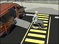
An access aisle or accessible aisle is a marked space in a parking lot that allows pedestrians to move from nearby footways to the parking lot to access their vehicles. Access aisles, as they are called in the United States, are required for loading and unloading wheelchairs. The United Kingdom has similar requirements, as do many other countries. However, an access aisle may also be located beside ordinary, non-disabled parking spaces.
How to map
Use this tag inside of an amenity=parking area or when using amenity=parking_space and parking_space=disabled. Draw an access aisle as a ![]() way to facilitate accurate routing.
way to facilitate accurate routing.
Create a way adjacent to the parking space, connecting the service=parking_aisle to the sidewalk (highway=footway footway=sidewalk) that borders the parking lot (or the edge of the parking lot if there is no sidewalk). Tag the new way as highway=footway and footway=access_aisle and access_aisle=disabled. If the adjacent parking space is for vans, add access_aisle=accessible_van.
Tag the node where the access aisle and sidewalk intersect with kerb=* and tactile_paving=yes, as appropriate. For better routing support it is recommended to tag the kerb and tactile paving as a node along the access aisle way and not at the intersection as that can negatively affect the routing along the connected sidewalk.
Examples
External links
- Urban parking design considerations – United Nations Department of Economic and Social Affairs Accessibility Design Manual
- Accessible Parking Spaces – United States Access Board Guide to the ADA Standards


