Tag:aeroway=launchpad
Jump to navigation
Jump to search
 |
| Description |
|---|
| A launchpad for a spacecraft. |
| Group: aeroways |
| Used on these elements |
| See also |
| Status: in use |
| Tools for this tag |
The tag aeroway=launchpad is used to map an above-ground facility from which a rocket-powered space vehicle is vertically launched to orbit or beyond, see ![]() Launch pad. Not to be confused with
Launch pad. Not to be confused with aeroway=launch_complex (including tower:type=launch_tower and other infrastructure).
![]() Single-stage-to-orbit
Single-stage-to-orbit ![]() Spaceplanes may probably take off from other
Spaceplanes may probably take off from other aeroway=* infrastructure. Also see other launchpad types in "similar tags" below.
How to map
- Create a closed way around the extent of the launch pad area.
- Add the tag
aeroway=launchpad. - For optional tags to use in combination see
aeroway=runway
Usually located within the area of a aeroway=launch_complex and / or aeroway=spaceport.
Examples
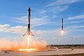
-
 Launch pad
 -

-
.jpg)
.jpg)
Similar tags
LOADING TAG LIST...
Possible errors
disused:*=* or abandoned:*=* launchpads should be tagged with the corresponding lifecycle prefix, the same applies for those proposed:*=*, planned:*=* or under construction:*=*.
See also
- aeroway - overview
aeroway:balloon=*- Infrastructure for balloon launch (to transport people or payload)aeroway:weather_control=*- For cloud seeding or weather balloonsaeroway:research=*- For launches below the Kármán line
aeroway:model_aerodrome=*- For modelsaeroway=helipad- For helicoptersmilitary=launchpad- For missilesaerospace:product=*- Different kinds of aerial or space vehicles