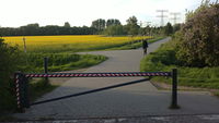
Tag:barrier=swing_gate
Jump to navigation
Jump to search
 |
| Description |
|---|
| A gate consisting of a bar or pole pivoted (rotates sidewards to open) in such a way as to allow the boom to block vehicular access through a controlled point. |
| Rendering in OSM Carto |
| Group: barriers |
| Used on these elements |
| Useful combination |
| Status: approved |
| Tools for this tag |
A swing gate is similar to a barrier=lift_gate but rotates sideways to open. It is usually made out of metal bars (although wood or other materials are possible, and can be tagged with material=*)and is intended to prevent limit vehicular access to authorized vehicles, but still permit general access by pedestrians and cyclists. Combine with access=* where appropriate.
Tagging
Types
| Key | Value | Element | Comment | Example pictures |
|---|---|---|---|---|
swing_gate:type=* |
single |
The road is blocked using one bar |  
| |
swing_gate:type=* |
double |
The road is blocked using two bars. | 
|
Access
Same recommendations for explicit access tagging are relevant as for Tag:barrier=lift_gate#Access.
See also
barrier=lift_gate- A bar or pole pivoted (rotates upwards to open) in such a way as to allow the boom to block vehicular access through a controlled point.barrier=sliding_beam- A bar or pole movably fixed on a rack and sliding aside in such a way as to allow the boom to block vehicular access through a controlled point.barrier=gate- used where the barrier is not just a few bars but an entire wing making impossible for pedestrians to walk under or over itbarrier=bar- used if the barrier is fixed, not open-able for authorized vehicles