Tag:barrier=gate
 |
| Description |
|---|
| A section in a wall or fence which can be opened to allow access. |
| Rendering in OSM Carto |
| Group: barriers |
| Used on these elements |
| Useful combination |
| See also |
| Status: approved |
| Tools for this tag |
A gate is a movable barrier, sometimes as a section of a wall or fence, which can be opened to allow or restrict access. They are usually made of wood or metal.
How to map
On a node
On a way barrier=wall/fence/etc. add a node with the tag barrier=gate at the gate's location.
For general information on how to map barriers as nodes refer to: Key:barrier § How to map barrier nodes.
On a way
Tag a way with barrier=gate on the real position and width of the gate, this should be connected to the fence at either side of the way.
Add a node on the intersection between any footways and the gate, also tagged with barrier=gate, much like how crossings are mapped. (This helps routers as many will just ignore the gate if there is no node.)
- Example (in JOSM editor)
-
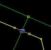 Correct: Gate as node on intersection between footway and gate way.

Tags used in combination
gate:type=*- distinguishes gate typeheight=*maxwidth=*- a legal width restrictionmaxwidth:physical=*- a physical width restrictionwidth=*- the width of the featureaccess=*:access=yes,access=private, etc.locked=*, whether the gate is usually locked and not accessible without the key.amenity=ticket_validator
Example
Based on the location below, the gate node should be the end of a way. A new way starts with the gate node and it should have the access set to private if the access is restricted.
+------+------•××××+××××+

See also
barrier=*barrier=wicket_gate— a pedestrian door or gate (note thatbarrier=gateis typically used instead).barrier=lift_gatebarrier=swing_gatebarrier=sliding_gatebarrier=kissing_gatebarrier=entrancebarrier=bollardbarrier=cattle_gridbarrier=chainbarrier=sally_portbarrier=coupure
building=gatehouseentrance=*- To allow entry into buildings and enclosed areasindoor=door- To allow entry between two rooms