Tag:bridge=covered
.jpg) |
| Description |
|---|
| Covered bridge |
| Group: bridges |
| Used on these elements |
| Implies |
| Useful combination |
| Status: approved |
| Tools for this tag |
|
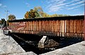
A ![]() covered bridge is a timber-truss bridge with a roof and siding which, in most covered bridges, create an almost complete enclosure. The purpose of the covering is to protect the wooden structural members from the weather. Uncovered wooden bridges have a life span of only 10 to 15 years because of the effects of rain and sun.
covered bridge is a timber-truss bridge with a roof and siding which, in most covered bridges, create an almost complete enclosure. The purpose of the covering is to protect the wooden structural members from the weather. Uncovered wooden bridges have a life span of only 10 to 15 years because of the effects of rain and sun.
Bridges not fitting this description can be tagged as bridge=* + covered=yes instead.
Where to find them
![]()
In the United States, covered bridges are typically found on low-traffic roads in rural areas, such as county or township roads or private driveways. Covered bridges are rare along arterial roads that need to accommodate more than one lane or heavier vehicles. Many historic covered bridges have been bypassed, with the original bridge remaining as a tourist attraction, while others have been moved to parks or fairgrounds and reused as pedestrian bridges. If you spot a covered bridge in aerial or street-level imagery, double-check it in the most recent imagery available, in case the bridge has recently been destroyed, moved, or bypassed.
How to map them
Add bridge=covered to the segment of highway=* or railway=* that passes over the bridge. Optionally, map a man_made=bridge area covering the entire roof, connect the roadway to the area at either portal, and add bridge=covered to the area as well.
Additional tags
Tags to add to the man_made=bridge area:
- bridge=covered
- building=bridge or building=roof[1], along with other Simple 3D buildings keys like roof:shape=gabled and roof:colour=*
- name=* – the name of the bridge
- start_date=* – the date the bridge was built or dedicated
- length=* – the length of the bridge, especially if signposted
- wikidata=* and/or wikipedia=*
- heritage=* and related keys if the bridge is on a historic register
Tags to add to the highway=* or railway=* way:
- bridge=covered
- bridge:name=* – the name of the bridge
- lanes=* – most covered bridges are one-lane bridges, so they take longer to cross
- maxheight=* – height restriction so that routers do not lead tall vehicles to damage the truss structure
- maxweight=* – weight limit so that routers do not lead heavy vehicles to collapse the bridge
- surface=* – traditional covered bridges have wood decks while some modern or retrofitted bridges have asphalt or concrete decks
In the United States, many covered bridges bear a plaque at either portal that states either the name of the bridge or the stream that it crosses, along with the year of construction. Height and weight restrictions may be posted on a sign on the bridge, next to the road in front of the bridge, or at the last intersection before the bridge. Some bridges have signs stating a lower clearance for the knee braces that extend diagonally to support the ceiling; add a maxheight:conditional=* tag conditioned on the width variable.
It may be appropriate to place a barrier=height_restrictor, highway=stop, or highway=give_way node along the roadway before the bridge in either direction.
Examples

West Dummerston Covered Bridge

Irgandı Bridge, Bursa, Turkey

Holzbrücke, Bad Säckingen
Oldest covered railroad bridge in the United States is located at Hopkinton

Hartland Bridge

Chengyang Bridge

Xijin Bridge in Zhejiang, China

"鞘橋" (Saya Bridge) in Kotohira, Japan


,_China.jpg)


United States (Ohio):
name=Geeting Bridge
ref=13
start_date=1894
On the roadway:
bridge:name=Geeting Bridge
lanes=1
maxweight=15 st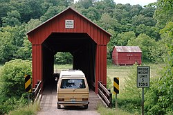
United States (Ohio):
name=Hune Bridge
ref:wgcb=33-84-27
On the roadway:
bridge:name=Hune Bridge
lanes=1
maxweight=5 st

United States (Ohio):
name=Root Road Covered Bridge
On the roadway:
bridge:name=Root Road Covered Bridge
lanes=1
maxheight=9'4"
maxheight:conditional=9'4" @ (width<6'); 8'2" @ (width>=6')
United States (Ohio):
name=Germantown Covered Bridge
start_date=1870
On the footpath:
bridge:name=Germantown Covered Bridge


- ↑ As of November 2021, building=roof is much more common, probably for compatibility with the Simple 3D buildings–compliant renderers.