Tag:leisure=disc_golf_course
 |
| Description |
|---|
| A place to play disc golf. |
| Group: leisure |
| Used on these elements |
| Implies |
| Useful combination |
|
| See also |
| Status: de facto |
| Tools for this tag |
|
A disc golf course is a course to play ![]() Disc golf, also known as frolf or frisbee golf.
Disc golf, also known as frolf or frisbee golf.
Disc golf is a sport in which players throw a disc at a target; it is played using rules similar to golf, usually played on a course with 9 or 18 "holes". Players complete a hole by throwing a disc from a tee area toward a basket, throwing again from where the previous throw landed, until the disc lands in the basket. Most disc golf courses are built in semi-natural environments, such as the edges of a park or other recreational areas and do not have a dedicated area like golf courses.
How to map
Disc golf courses often don't have a well-defined area like a regular leisure=golf_course.
To add the whole course, the easy way is to add a node near the first hole or the map of the whole course and add all the information there. To add the whole course completely, add the ways ![]() with
with disc_golf=hole for every hole. A hole should include ref=* to indicate which hole this is and par=* for the number of strokes normally required to complete a disc golf hole.
Add disc_golf=tee on the node ![]() at the beginning of the hole and
at the beginning of the hole and disc_golf=basket to the node ![]() at the end of the hole.
at the end of the hole.
Add everything to a relation ![]() with
with type=disc_golf_course / disc_golf_course and add leisure=disc_golf_course and name=* if the course has a name. The hole as members get the role ![]() hole
hole
Tags to use in combination
name=*disc_golf:course=*- number of holesdisc_golf:course=9_hole- 9-hole disc golf coursedisc_golf:course=18_hole- 18 - hole disc golf course
disc_golf:par=*- Total par of a course, combined with the number of holes indicating the difficulty of courseaddr:*=*operator=*phone=*website=*opening_hours=*opening_hours=24/7- Accessible without restrictions
fee=yes/nocontact:*=*
Features within a disc golf course
For details on how to map/tag features refer to their specific pages.
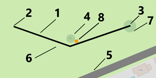
You can see in the table below, or by referring to , there are several keys without an associated page. The undocumented features are subject to a current proposal in development to flesh out the proper tag set and usage.
Applies to all features:
| Map Illustration Key | |||
|---|---|---|---|
| Feature | Element | Description | Number |
hole |
A hole is represented by a way along the standard playing path from the tee to the green. Should include ref=* to indicate which hole this is. |
1 | |
tee |
An area where play begins on a golf hole. | 2 | |
basket |
Ending point of a disc golf hole. | 3 | |
mando |
(Optional) An object (or line) that must be passed on a specific side. Sometimes used to mark the plane that has to be passed instead. | 4 | |
out_of_bounds |
(Optional) A line or area that must not be touched or crossed with the disc. | 5 | |
fairway
|
(Optional) An area between the tee and basket. Usually comprising clearings, meadows etc). | 6 | |
island |
(Optional) Area around the basket that is exclusively in bounds. | 7 | |
drop_zone
|
(Optional) Dedicated location from which players resume playing after making an error such as not correctly passing a mando. | 8 | |
| putting | (not implemented) Practice area. Alternative is 'putt_range' or 'putt_training' | ||
| dropbox | (not implemented) Location of lost and found. | ||
clubhouse |
The building dedicated as a clubhouse. Always tag building=* for the building itself. |
||
Common mapping pitfalls
- Using
disc_golf=pininstead ofdisc_golf=basket. - Using
golf=*anywhere on the disc golf course. - Using
ref=*somewhere else than onhole. - Using
name=*on every hole instead or additionally toref=*to force a rendering. See more: Tagging for the renderer - Using
landuse=*ornatural=*to indicate its surface. Usesurface=*instead.
Similar tags
leisure=golf_course- Golf Courseleisure=miniature_golf- For a mini-golf/crazy golf centre.leisure=soccer_golf- Footgolfsport=croquet- Croquet
Examples
- PlanetDG - To discover mapped Disc Golf Parcours
- Wiener Prater Disc Golf Parcours
- DiscGolfPark Běchovice Main
- Disc Golf Gurten - Inclusion of tees and baskets in relations need to be discussed
- Skatås DBG - 18 holes
