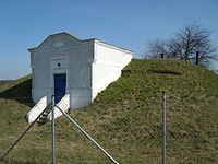
Tag:man_made=reservoir_covered
Jump to navigation
Jump to search
 |
| Description |
|---|
| A covered reservoir is a large man-made tank for holding fresh water |
| Group: man made |
| Used on these elements |
| Useful combination |
| Status: de facto |
| Tools for this tag |
A covered reservoir is a large man-made tank for holding water. When at suitable elevation, the installation supplies pressure to the water network below. Such reservoirs are hence functionally equivalent to water towers.
How to map
Draw an area along outline of the reservoir. If that is infeasible, set a node at the center of the reservoir.
Add man_made=reservoir_covered.
Tags used in combination
content=*- describe the contentsoperator=*- name of the entity operating the reservoir (council, private company, etc.)capacity=in cubic metres- Describes the capacity a facility is suitable foraccess=yes/private/permissive/no- For describing the legal accessibility of a feature
See also
man_made=storage_tank+content=water- A container that holds wateremergency=water_tank- A large water basin or tank for a fire department to take waterman_made=water_tower- A structure with a water tank at an altitude to increase pressure in water networknatural=water+water=reservoir- An enlarged natural or artificial lake, pond, or impoundment, created using a dam to store water- Proposed_features/water_network