Tag:service=alley
| Description |
|---|
| An alley is a service road usually located between properties for access to utilities. |
| Group: highways |
| Used on these elements |
| Requires |
| Status: de facto |
| Tools for this tag |
|
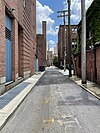
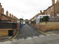
An alley or alleyway is a narrow service road usually located between properties to provide access to back gardens, rear entrances, fire exits, and storage areas. Alleys are normally found in urban areas and often run between the rear sides of buildings such as houses, and commercial premises.
Old, narrow streets that provide access to the main entrances of buildings may also be mapped as alleys, distinguishing them from wider modern streets mapped, for example, as highway=residential. In some regions, this case is much more common than the rear access case.
In other regions[1][2], using service=alley for narrow roads that provide access to the main entrances of residences is considered a form of tagging for the renderer and is discouraged. Local mappers are advised to use instead highway=residential along with the relevant width=* and lanes=* tags.
If a narrow street is prohibited for motor vehicles, consider using highway=pedestrian. If a narrow passage is prohibited for motor vehicles, consider using highway=footway.
Old or medieval ways
The very narrow old public streets which run in-between buildings in some settlements, such as the medieval European ones, often allowing through traffic, may be mapped using service=alley.
| Possible and legal for motor vehicles | Impossible (e.g. steps) or illegal for motor vehicles | ||
|---|---|---|---|
| Narrow highway=service + service=alley |
Illegal for motor vehicles highway=footway |
||
| Steps highway=steps |
|||
| Wide highway=residential |
Wide enough but illegal highway=pedestrian |
||
Alley streets
Alley streets are a road classification found in Baltimore, Maryland, USA[3], and potentially other places. Alley streets are alleys by definition, i.e., they serve the rear of buildings, but are named. Most named alley streets have addresses assigned to them, often small homes or carriage-houses that have been converted into homes, due to Next Generation 911 (NG911) standards that require local governments to sign any public street with addresses. Alley streets may have sidewalks but they are small and designed to house trash cans or steps down from homes. Alley streets do not typically have on-street parking, which distinguishes them from residential streets.
| Tagging | Example |
|---|---|
| Ploy Street, alley street with a narrow sidewalk highway=service + service=alley + sidewalk=both + surface=asphalt |

|
| Teakle Alley, an alley street that looks like a standard alley with no sidewalk highway=service + service=alley + sidewalk=no + surface=concrete |

|
Usage
Examples
- United States
Bardes Alley, Cincinnati
Ira Alley, Cincinnati
Unnamed alley, Chicago
Unnamed alley, Minneapolis
See also
footway=alley : Narrow streets where cars can't pass and people can barely get by.


