Tag:surface=laterite
 |
| Description |
|---|
| Unpaved road or track surfaced with lateritic soil: red-orange tropical soil, firm and dusty when dry, slippery then potentially impassable when wet. |
| Group: properties |
| Used on these elements |
| Useful combination |
| See also |
| Status: approved |
| Tools for this tag |
Surface tag for roads, tracks, paths, and footways surfaced with lateritic soil: a cohesive, usually red or orange-red, iron- and aluminium-oxide-rich tropical or subtropical soil. Becomes slippery on first wetting, then plastic and sticky under sustained rain, making it potentially impassable; hardens to firm and dusty in dry conditions.
Field identification
No geological expertise is required. Use multiple observable signals together:
- Geography: mostly tropical/subtropical; uncommon outside these zones.
- Colour: usually red to orange-brown; the range spans yellow-orange to deep reddish-brown.[1] Can lighten to orange-beige when dry, darken toward brown when wet. Clay minerals are naturally white to light-coloured;[2] intense red/orange indicates iron-oxide influence, consistent with laterite. Wet-state colour alone is non-diagnostic.
- Wet behaviour, phase 1 (first wetting): The iron-oxide cement releases on first rain, producing a near-frictionless slip layer over a still-firm base: sudden, severe traction loss before the road has visibly changed. Can develop within minutes.[3] Affects pedestrians too: barefoot walking becomes impossible before the road visibly softens.
- Wet behaviour, phase 2 (sustained wet): Plasticity penetrates throughout: deeply sticky, adhesive to vehicles and footwear, and potentially impassable.
- Drying pattern: polygonal cracking after wet periods.
- Drainage: puddles persist longer than on sand or gravel.
- Structure: cohesive cut banks, not loose or crumbling. Deterioration takes the form of potholes in flatter or lower-traffic contexts and deep ruts in heavily trafficked zones; cohesion is retained in intact sections in both cases.
Practical rule: tropical setting + cohesion + wet-season plasticity (+ usually red/orange) supports surface=laterite. If uncertain on the ground, use surface=dirt or surface=ground; if mapping from imagery alone, use surface=unpaved.
-
 Global extent of lateritic soils.
 -
 Wet phase 1: truck slipped on first wetting.
 -
 Wet phase 2: sticky and plastic.
 -
 Adhesion to vehicles and footwear.
 -
 Desiccation cracking after wet-dry cycle.
 -
 Cohesive cut banks with red-orange iron staining.
 -
 Firm surface, dry season.


Tagging
Recommended combinations
surface=laterite describes material identity. Add condition tags separately:
smoothness=*: use the most common or typical conditions as the base value, not the dry-season state alone.tracktype=grade3is the appropriate default for natural laterite. Use grade2 only for roads demonstrably firm year-round (approachingsurface=compactedbehaviour); dry-season firmness alone does not justify grade2. Note: no standard OSM tag yet exists for weather-dependent passability.
Relations to other tags
surface=mud: for places that are wet nearly all year and never or rarely dry. Laterite alternates between firm and plastic seasonally; usesurface=lateriteregardless of current conditions.surface=mudapplies only in the rare case where a laterite surface stays muddy year-round and never dries.surface=dirt/surface=ground: fallbacks when the material cannot be confirmed on the ground.surface=dirtwhen it is clearly a natural soil road;surface=groundwhen the surface type is indeterminate.surface=unpaved: the correct fallback for imagery-only mapping, where only the absence of paving can be confirmed.
Full tagging decision table (boundary cases, din lukrang, murram, compacted vs laterite) is in Proposal:Surface=laterite/Science.
Possible tagging mistakes
- Do not use
material=lateritealone onhighway=*ways wheresurface=lateriteis known. - Do not infer laterite from colour alone: even in tropical areas, ground-level photography or confirmed local knowledge is required to confirm the material.
- Do not use
surface=lateritefor loose red sand; usesurface=sand.
Router guidance
surface=laterite warrants a significantly higher penalty than surface=dirt or surface=clay. In tropical regions, laterite roads are in a wet or transitional state for more than half the year: the risk window extends several weeks before and after the official rainy season, as off-season rain is sufficient to trigger phase 1. In northern Thailand, for example, trails can be slippery from April through early December, roughly eight months. The wet state has two distinct phases:
- Phase 1 (first wetting): the iron-oxide surface cement releases within minutes of rain, producing near-frictionless slip over a still-firm base. The road looks dry and hard but provides almost no traction: a black-ice scenario, not a mud advisory.
- Phase 2 (sustained wet): the surface becomes deeply plastic and adhesive, potentially impassable to all but the heaviest four-wheel-drive vehicles.
Both phases occur on roads that look passable until the moment they are not. A generic dirt or clay penalty does not capture this risk.
Examples
-
 Thailand. Dry-season laterite track, Thung Salang Luang National Park.
 -
 Ethiopia. Red-orange laterite, dry season.
 -
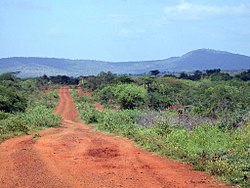
 Uganda. Firm red laterite road, dry season.
 -
 Laos. Deep red-orange laterite road.
 -
 Argentina. Basalt-derived latosol (tierra colorada).
 -
 India (Kerala). Wet-season laterite track.

.jpg)

.jpg)


Counter-examples
Colour alone is not enough. Iron-stained rock, volcanic soils, and red sandstone gravel can look similar but are not cohesive or plastic like laterite. Outside tropical/subtropical settings, laterite is unlikely.
-
 Kyrgyzstan: iron-stained crushed rock, not laterite.
 -
 Utah (BLM): deep loose sand, not laterite.

.jpg)
See also
External links
Software support
- Open: iD, BRouter, OpenStreetMap Carto, OpenTopoMap
- Completed: StreetComplete, Vespucci, OSRM, GraphHopper, OsmAnd, Valhalla, Organic Maps, CoMaps, Tracestrack Topo, OpenMapTiles, Planetiler, JOSM, CyclOSM
References
- ↑ Pinard, M.I., Netterberg, F., Paige-Green, P. (2014). Review of Specifications for the Use of Laterite in Road Pavements. AFCAP Contract AFCAP/GEN/124. Crown Agents / UKAID.
- ↑ Wikipedia: Clay. "Clay-size particles and clay minerals are not the same, despite a degree of overlap in their respective definitions."
- ↑ Gidigasu, M.D. (1974). "Identification of Problem Laterite Soils in Highway Engineering: A Review". Transportation Research Record 497, pp. 96–111. Transportation Research Board, Washington D.C.