User:ConsEbt/NorthernBeachesSolar
Why? Inspired by this and this page which I found via http://blog.openstreetmap.de I thought this can be done in Australia, NSW, Northern Beaches to.
Thanks to the NSW provided satellite images many rooftop solar panels are visible and easy to map.
Rooftop solar panels are often very visible - they should be fairly easy to map. And to a small extent, once mapped they serve as landmarks for within residential areas.
How to find rooftop solar PV?
LPI NSW Imagery is our friend here with mostly good high resolution and recent images for the Northern Beaches.
Types of rooftop solar PV
I will focus to map soalar PV panels visible on imagery. If I stumble across a cleanly identifiable solar thermal collector I'll map that too.
How to tag rooftop solar PV
- I will follow what has been established already.
- I will map using an area and apply the following tags
- The area nodes should be within the visible panel, not mapping around the item but on the line or smaller.
- For now I will refrain from adding area estimation. In my view this should be deducted from the mapped area in an automated way.
- If the building that the panel is on is not mapped yet I will make it so and merge any existing address information
Tags used
power=generatorgenerator:source=solargenerator:method=photovoltaicgenerator:type=solar_photovoltaic_panelgenerator:place=roofgenerator:output:electricity=small_installationgenerator:solar:modules=*- the number of panels, often installed in one or multiple rows - a "module" is a single rectangular unit.
start_date=*- set to the date of the LPI NSW Imagery - or should this be rather source:date=*??source=LPI NSW Imagery
Copy and paste blob:
power=generator
generator:source=solar
generator:method=photovoltaic
generator:type=solar_photovoltaic_panel
generator:place=roof
generator:output:electricity=small_installation
generator:solar:modules=xxxxx
source=LPI NSW Imagery
source:date=YYYY-MM-DD
Tag considerations
- I use generator:place=roof instead of location=roof because it ties the location to the generator. A pure location=roof could be anything.
- I use generator:output:electricity=small_installation as suggested here to indicate that this is a small, likely private installation.
- Rather than noting the number of panels in a
note=*I will add them usinggenerator:solar:modules=*note=12 panels, roof top - I could include roof orientation as suggested on the OpenSolarMap page. However some roofs are quite complete and I need to figure out how to split up the house.
- For this tags that are required are: roof:orientation=along/across and roof:shape=0.0 for flat roofs.
How to tag rooftop solar thermal?
Following same schema as above
power=generatorgenerator:source=solargenerator:method=thermalgenerator:type=solar_thermal_collectorgenerator:place=roofgenerator:output:heat=small_installationgenerator:solar:modules=*- the number of panels, often installed in one or multiple rows - a "module" is a single rectangular unit.start_date=*source=LPI NSW Imagerysource:date=*
Copy and paste blob:
power=generator
generator:source=solar
generator:method=thermal
generator:type=solar_thermal_collector
generator:place=roof
generator:output:heat=small_installation
generator:solar:modules=xxxxx
source=LPI NSW Imagery
source:date=YYYY-MM-DD
Statistics and existing data
- Oxford Falls - [1]
- Narrabeen - openinframap.org
- Bilgola Beach
- First steps @ Narrabeen
- http://www.cleanenergyregulator.gov.au/RET/Forms-and-resources/Postcode-data-for-small-scale-installations
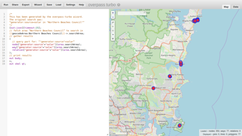
overpass-turbo view of the Northern Beaches Council
Status at the beginning, December 2019

See also/References
- Example of mapped panels in Berry, NSW
- Renewable_energy_in_the_United_Kingdom
- OpenInfraMap
- introduction of the project to Talk-AU