User:Davetoo/NHD/main redo
The National Hydrography Dataset (NHD) is a United States-wide hydrography dataset suitable for import into OpenStreetMap.
This page details the process, progress, and mapping as the dataset is imported.
Overview
Tools and workflows
Shapefiles to OSM
- http://svn.openstreetmap.org/applications/utils/import/nhd2osm/ is a set of four similar python tools, one each for NHD Line, Flowline, Waterbody, and Area shapefiles. They do have some defaults (and assumptions) built in; most notably, by default they ignore FCODE 55800, Artificial Path.
- http://redmine.yellowbkpk.com/projects/list_files/geo is a more general-purpose Java shapefile-to-osm conversion tool.
OSM to Shapefiles
Those of us with access to GIS software may wish to bring existing hydrography-related OSM data into a GIS to make use of more powerful tools to identify collisions and conflicts.
- http://osmlib.rubyforge.org/osmlib-export/index.html is a package that can convert OSM data to shapefiles, based on a flexible ruleset (in reality, ruby code snippets).
Process
Python scripts for converting the shape files can be found at http://svn.openstreetmap.org/applications/utils/import/nhd2osm/
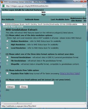
Obtain High Resolution shapefiles from the NHD web site by using the NHD Viewer. Read the "How to extract" instruction on the left, pop-ups must be enabled for the site.
Mapping
| SHP Key | OSM Tag(s) | Description |
|---|---|---|
| ComID | nhd-shp:com_id | Common ID. Unique to all of NHD data. |
| FDate | nhd-shp:fdate | Capture date. |
| GNIS_ID | gnis:id | USGS Geographic Names Information System feature identifier. |
| Elevation | ele | Feature elevation. Not used very often. |
The NHD data comes in shapefiles, but most information is built into the single "FCode" field. The below describes a possible mapping.
| FType | FCode | OSM Tag(s) | Description |
|---|---|---|---|
| ArtificialPath | 55800 | name:-, waterway:river | Artificial paths are usually used to indicate the centerlines for rivers that are wide enough to designate with an multipolygon. |
| CanalDitch | 33600 | waterway:canal; some may need to be hand-edited to waterway:drain | A canal or ditch (usually with a concrete or earthen surround). |
| Connector | 33400 | ??? | "A known, but nonspecific connection between two nonadjacent network segments" [1] |
| StreamRiver | 46003 | waterway:stream? | Intermittent streams. |
| StreamRiver | 46006 | waterway:river | Permanent/perennial rivers. |
| FType | FCode | OSM Tag(s) | Description |
|---|---|---|---|
| StreamRiver | 46006 | waterway:riverbank | The polygon riverbank for a river that should be drawn wider than a line. This polygon will surround a line of code 55800 with the river's name. |
| FType | FCode | OSM Tag(s) | Description |
|---|---|---|---|
| BayInlet | 31200 | natural:bay, might need to be natural:coastline | Bay or inlet. |
| LakePond | 39001 | natural:water, occurrence:intermittent?? | Intermittently visible lake/pond. |
| LakePond | 39004 | natural:water | More permanently visible lake/pond. |
| Reservoir | 43612 | man_made:wastewater_plant | Sewage treatment pond. |
| SwampMarsh | 46600 | natural:wetland | A generic swamp/marsh area. |
(See http://nhd.usgs.gov/chapter1/index.html#_Toc435603829)
Progress
Interested
- Alexrudd
- crschmidt
- Working in MA, intersecting subbasins are:
 01090003 Blackstone; state(s): MA, RI
 01090002 Cape Cod; state(s): MA, RI
 01090001 Charles; state(s): MA
 01080204 Chicopee; state(s): MA
 01070005 Concord; state(s): MA
 01080203 Deerfield; state(s): MA, VT
 01080207 Farmington; state(s): CT, MA
 01100005 Housatonic; state(s): CT, MA, NY
 02020003 Hudson-Hoosic; state(s): MA, NY, VT
 01080205 Lower Connecticut; state(s): CT, MA
 01070002 Merrimack; state(s): MA, NH
 01080201 Middle Connecticut; state(s): MA, NH, VT
 02020006 Middle Hudson; state(s): MA, NY
 01080202 Miller; state(s): MA, NH
 01090004 Narragansett; state(s): MA, RI
 01070004 Nashua; state(s): MA, NH
 01060003 Piscataqua-Salmon Falls; state(s): MA, ME, NH
 01100001 Quinebaug; state(s): CT, MA, RI
 01100002 Shetucket; state(s): CT, MA
 01080206 Westfield; state(s): CT, MA
- Karl Newman
- M. Schneider
- Liber
- Adam Schreiber
- Mike N
- Working in SC
 03050105 SC: Upper Broad River Basin (SC and NC)
 03050107 SC: Tyger River Basin
 03050108 SC: Enoree River Basin
 03050109 SC: Saluda River Basin
- Jeff Ollie
- Working in IA
 07100004 Middle Des Moines; state(s): IA
 07080105 South Skunk; state(s): IA
 07100008 Lake Red Rock; state(s): IA
- Jared Campbell
- Working in DC Metro Area and Ohio
- jumbanho
- Working in North Carolina
- abgandar
- Working in Michigan
Proposed Tags for all NHD keys
Some of the fcodes have been changed from the version on this list. For details, see: [2]
|
FCODE |
Feature Type |
OSM Tag |
Description |
|
30200 |
ANCHORAGE |
waterway=dock |
feature type only: no attributes |
|
30201 |
ANCHORAGE |
waterway=dock |
Anchorage Type|explosives isolation |
Completed Basins
The following (sub)basins have been uploaded:
