WikiProject Belgium/Sonian Forest
Forêt de Soignes / Zoniënwoud / Sonian Forest
Cycling
Cycling routes
WikiProject Belgium/Cycle Routes
- LF2
- LF6
- RV10
- ICR / GFR 4
- ICR / GFR 5B
- ICR / GFR 6A
- ICR / GFR MM
- Promenade Verte / Groene Wandeling
- Bloso Mountainbikeroute (27 km, Startplaatsen: Sporthal Hoeilaart, Station Groenendaal) [1][2]
Cycling nodes
- 43
- 44
- 46
- 60
Walking routes
 GR126
GR126- GR512
- GR579
- GR126 - GR579
- Promenade Verte / Groene Wandeling
- Balades / Wandelingen [3]
- 1
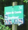
 Balade de la Forêt de Soignes bruxelloise / Wandeling in het Brusselse deel van het Zoniënwoud (23 km)
 - 2 Sentier éducatif Rouge-Cloître / Leerwandelpad Rood Klooster (4 km)
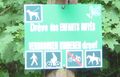
- 4 Sentier éducatif des Enfants Noyés / Leerwandelpad Verdronken Kinderen (3.4 km, Blue sign)
- 5 Promenade Ruusbroec / Ruusbroecwandeling (5.4 km, Orange post [4])
- 6 Promenade du Chêne De Bruyn (Schone-Eik) / De Schone-Eikwandeling (8.5 km, Red sign)
- 7 Promenade de l'Espinette centrale (Middenhut) / Middenhutwandeling (9 km, Blue post)
- 8 Promenade du Hazendal / Hazendalwandeling (3.5 km, Red post [5])
- 9 Promenade du Flossendelle / Flossendellewandeling (6 km, Blue post)
- 10 Promenade de la Warande / Warandewandeling (5.6 km, Blue post)
- 11 Promenade du Kapbos de Duisburg / Kapboswandeling Duisburg (9 km, Yellow post)
- 12 Sentier didactique au parc Tournay-Solvay / Leerpad van het Tournay-Solvay-park (2 km)
- 1
Running routes
- 5 km
- 10 km
- 20 km [6]
Parts
Brussels Capital Region
38% of the forest is in Brussels Capital Region.
-
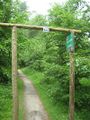
 Gate for cars
barrier=gate -
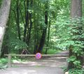
 Blocking horseback riders
barrier=? -
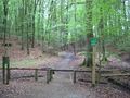 Cycle barrier
barrier=cycle_barrier -
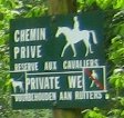
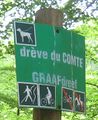
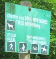
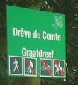
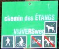 Sign with restrictions
 -
 Horseback riders only
 -
 Only cycle and foot, dog on leash
 -
 No restriction, dog on leash
 -
 Foot only
 -
 Foot only, dog on leash
 -
 No horse.
 -
 No motorcycle, dog on leash


Vlaams Brabant
56% of the forest is in Flemish Brabant.
Brabant wallon
6% of the forest is in Walloon Brabant.
Forêt de Soignes / Zoniënwoud highways tagging guidelines (draft)
(Following the discussions on the talk-be mailing list, here is a draft.)
010 is the highway physically designed for motor cars, forestry trucks, etc.? yes, goto 100 | no, goto 015
015 is it designated for horses? yes, goto 140 | no, goto 020
020 is it designated for bicycle? yes, goto 165 | no, goto 200
100 tag highway=track (e.g. drève, etc., with access for forestry trucks)
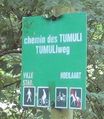
105 tag surface=asphalt or surface=concrete or surface=gravel or surface=ground, etc. (e.g. Drève des Tumuli : asphalt)
110 precise restrictions e.g. motorcar=no or bicycle=yes, etc.
115 if appliable, tag oneway=yes or oneway=no
120 if appliable, tag noexit=yes or noexit=no
145 tag surface=* with paved | unpaved | asphalt | concrete | cobblestone | gravel | sand
170 tag surface=* with paved | unpaved | asphalt | concrete | cobblestone | gravel
205 tag surface=* with paved | unpaved | asphalt | concrete | cobblestone | compacted | gravel
210 tag bicycle=yes or bicycle=no or bicycle=designated
215 tag horse=yes or horse=no or horse=designated
220 tag foot=yes or foot=no or foot=designated
225 tag motorcycle=yes or motorcycle=no
230 tag access=*
Notes:
- See also: http://wiki.openstreetmap.org/wiki/Hiking).
- Refer to the tagging scheme of the Forêt de Fontainebleau, France.
- (path and not footway; IMHO footway is for urban areas; see: Footway: For designated footpaths, i.e. mainly/exclusively for pedestrians.)
Foxandpotatoes 17:22, 26 February 2010 (UTC)