File:Sea boundaries.png
Jump to navigation
Jump to search

No higher resolution available.
Sea_boundaries.png (587 × 386 pixels, file size: 43 KB, MIME type: image/png)
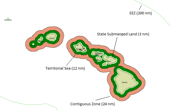
Sea boundaries around Hawaii
File history
Click on a date/time to view the file as it appeared at that time.
| Date/Time | Thumbnail | Dimensions | User | Comment | |
|---|---|---|---|---|---|
| current | 22:58, 7 November 2009 | | 587 × 386 (43 KB) | Ksamples (talk | contribs) | Sea boundaries around Hawaii |
You cannot overwrite this file.
File usage
The following 74 pages use this file:
- Ar:Map Features
- Ast:Map Features
- Az:Map Features
- Bg:Map Features
- Ca:Elements cartogràfics
- Cs:Key:boundary
- Cs:Map Features
- Cs:Tag:boundary=maritime
- Da:Map Features
- El:Map Features
- Eo:Map Features
- Fa:Map Features
- Fi:Kartan ominaisuudet
- He:Map Features
- Hu:Map Features
- Key:boundary
- Lv:Map Features
- Map features
- Marine
- Ne:Map Features
- No:Tag:boundary=maritime
- Pl:Key:boundary
- Pl:Tag:boundary=maritime
- Pt:Map Features
- Pt:Tag:boundary=maritime
- Ro-md:Map Features
- Ro:Map Features
- Sr:Map Features
- Sv:Map Features
- Tag:boundary=maritime
- Tr:Key:boundary
- Uk:Key:boundary
- Uk:Об'єкти мапи
- Zh-hans:Map Features
- Zh-hant:Map Features
- User:Chillly/Simple Map Features
- User:H4ck3rm1k3/OSMKeys
- User:Mateusz Konieczny/notify uploaders/Ksamples
- Wiki:Files used by data items/4
- Template:Ar:Map Features:boundary
- Template:Az:Map Features:boundary
- Template:Ca:Map Features:boundary
- Template:Cs:Map Features:boundary
- Template:DE:Map Features:boundary
- Template:Da:Map Features:boundary
- Template:El:Map Features:boundary
- Template:Eo:Map Features:boundary
- Template:Et:Map Features:boundary
- Template:FR:Map Features:boundary
- Template:Fi:Map Features:boundary
- Template:Generic:ES:Map Features:boundary
- Template:Hu:Map Features:boundary
- Template:IT:Map Features:boundary
- Template:JA:Map Features:boundary
- Template:Map Features:boundary
- Template:NL:Map Features:boundary
- Template:Pl:Map Features:boundary
- Template:Pt:Map Features:boundary
- Template:RU:Map Features:boundary
- Template:Sv:Map Features:boundary
- Template:Uk:Map Features:boundary
- Template:Zh-hant:Map Features:boundary
- DE:Key:boundary
- FR:Environnement marin
- FR:Éléments cartographiques
- ES:Marino
- ES:Tag:boundary=maritime
- IT:Map Features
- NL:Kaartelementen
- RU:Key:boundary
- RU:Море
- JA:Key:boundary
- JA:Map Features
- JA:Tag:boundary=maritime