Parked image proposals

The following are Featured image proposals which were put forward, but they have been "parked".
Parked?
Parked means they could be used, but the proposal didn't really go anywhere for some reason. They have been moved here because they could still be rescued, but we are aiming to keep the Featured image proposals page a bit shorter, because otherwise it gives the wrong impression, that we have lots of good proposals to choose from (not the case!).
Reasons for parking a proposal:
- open licensing - We need to hear back from the copyright owner to gain permissions (we require open licensed images without commercial restrictions, and it's useful if a clear statement can be made here on the image description page, by a user who is clearly the copyright owner)
- license compliance - The image depicts a nice use of OpenStreetMap, but sadly the use is not compliant with the OpenStreetMap License (usually means they don't give us adequate credit. See Legal FAQ ) This may be resolved over time if the user can be cajoled into complying. Note these are legal requirements, so we should approach people nicely, but it's not just so that they can have a featured image.
- quality - It was felt that the image didn't meet the quality threshold. It wasn't quite worthy of being "image of the week". Images which are kind of OKish may be useful to keep as parked images here, so that we can rescue the proposal in the event of a drought in suggested images (which happens quite a lot actually!). Images which are pretty hopeless can just be removed from the list to save space
- repetition - or other considerations. This amounts to a kind of quality consideration, but it may be that an image is parked because, even though it's a great image, we have already featured a similar one... or some other consideration.
Note that these states can often be resolved through a process of discussion (and tracking down the right people to discuss). You are welcome to continue discussing the image proposals here, and move them back to Featured image proposals if they seem like a good proposal again.
Indian Railways Network Connectivity Map

"Indian Railways Network Connectivity Map with cities and population density"
It's in my eyes also a very nice, interesting map. --Kolossos (talk) 13:46, 31 May 2013 (UTC)
- Image mentions (in small print) that it is OSM data, but the info on the page doesn't ... ---Aseerel4c26 (talk) 00:55, 2 June 2013 (UTC)
- Another (perhaps minor) disadvantage is that we've already featured a lot of awesome map images by User:Planemad. -- Harry Wood (talk) 13:54, 3 June 2013 (UTC)
- I've no concerns with the license and so I would like to feature this nice map as iotw. --LordOfMaps (talk) 14:19, 14 April 2014 (UTC)
- This is a bad example of OSM attribution. You really have "no concerns"? Do you think we should not take our own license for real? However, do it. Not the first image with license issues. It does not get better by just ignoring! Sorry for having a look here again... ;-) --Aseerel4c26 (talk) 23:46, 18 May 2014 (UTC)
- In my eyes it isn't a perfect attribution, but it is an attribution including the author (Openstreetmap Project) and the license (cc-by-sa), so it should be OK. And I take our own license for real. --LordOfMaps (talk) 12:24, 19 May 2014 (UTC)
- This is a bad example of OSM attribution. You really have "no concerns"? Do you think we should not take our own license for real? However, do it. Not the first image with license issues. It does not get better by just ignoring! Sorry for having a look here again... ;-) --Aseerel4c26 (talk) 23:46, 18 May 2014 (UTC)
- I've no concerns with the license and so I would like to feature this nice map as iotw. --LordOfMaps (talk) 14:19, 14 April 2014 (UTC)
- Another (perhaps minor) disadvantage is that we've already featured a lot of awesome map images by User:Planemad. -- Harry Wood (talk) 13:54, 3 June 2013 (UTC)
Aside form license issues (which I think is minor) ...this is now a very old image. Also we have featured User:Planemad's nice maps before, so I think it's a bit repetitive -- Harry Wood (talk) 13:59, 9 December 2014 (UTC)
Ballonmap with OpenLayers

en = A citizens' initiative against nuclear waste in a residential area uses OSM and OpenLayers for the visualisation of a ballon-action. The ballon-cloud, visible in the map, symbolises the spreading of radioactivity in case of an accident.
Screenshot from: http://www.atomalarm2013.de/doku.php?id=luftballonaktion
Baselayer: mapnik
The author allowed the usage in the wiki. The author agreed to a free license of his work.
Proposed as itow. --Bma (talk) 17:03, 9 December 2013 (UTC)
- Thank you for the proposal (with those already translated captions which we will put on the file page in any case), Bma! Three issues:
- I am not that much impressed by "just" an OpenLayers map with the standard mapnik layer and some bitmap markers (however it is still great that OSM is used!; also see).
- Second, the image should be freely licensed (for everyone, not just for the wiki) – however, this can be easily fixed: the mapnik tiles are cc-by-sa 2.0 anyway and the icons and those few markers may not be protected (a free license statement by the author would be good).
- Third, admittedly I have a bit stomach-ache featuring such a political topic which does a (at least scientifically) doubtful comparison of radioactive fallout and balloon landing locations (that does not mean that I am against this project). Next week we feature a map of bird deaths by wind energy (just an illustrative example)? I mean, it is hard to find the right balance of promoting those quite political opinions then.
- I am personally sorry for rather downvoting your proposal. I'd like to hear others' opinions. --Aseerel4c26 (talk) 21:38, 10 December 2013 (UTC)
- The author agreed to a free license of his work. And of course it was rather an symbolic action than a scientifical experiment. --Bma (talk) 17:51, 11 December 2013 (UTC)
- Thank you for your response, still, a license is missing at File:Ballon_map_v1.png#Licensing. I think the only possible license for the whole is the same license which the basemap is licensed under (due to its "share alike" requirement). So, the author should release his work under "Creative Commons Attribution-ShareAlike 2.0 License" (auf Deutsch) if possible.
And who is the author of the balloon map? On the source website I cannot find a license info, but on the opposite I find e.g. "Downloads und Kopien dieser Seite sind nur für den privaten, nicht kommerziellen Gebrauch gestattet." at [1]. This is nearly the opposite of a free license. --Aseerel4c26 (talk) 19:53, 11 December 2013 (UTC)- The author agreed to a "Creative Commons Attribution-ShareAlike 2.0 License". (Changed on the file-page.) --Bma (talk) 11:37, 13 December 2013 (UTC)
- Thank you, but where can I see this? The website still has the same (opposite) copyright statements, if I see correctly. --Aseerel4c26 (talk) 22:47, 13 December 2013 (UTC)
- The author agreed to a "Creative Commons Attribution-ShareAlike 2.0 License". (Changed on the file-page.) --Bma (talk) 11:37, 13 December 2013 (UTC)
- Thank you for your response, still, a license is missing at File:Ballon_map_v1.png#Licensing. I think the only possible license for the whole is the same license which the basemap is licensed under (due to its "share alike" requirement). So, the author should release his work under "Creative Commons Attribution-ShareAlike 2.0 License" (auf Deutsch) if possible.
- The author agreed to a free license of his work. And of course it was rather an symbolic action than a scientifical experiment. --Bma (talk) 17:51, 11 December 2013 (UTC)
- You wanted to hear others' opinions: I have no problem with the image. I would feature it as itow. It is a good example for the multifaceted using-possibilities of OSM.--LordOfMaps (talk) 12:55, 13 December 2013 (UTC)
- Thank you. Yes, it is a a good example (still a quite random one - see "first"). As said, it is issue of neutrality or not. However, many iotw are "adverts" in some form (the only difference is that here it is a quite political/opinion advert – somehow). Good, old Harry, please "decide" or comment! ;-) --Aseerel4c26 (talk) 22:47, 13 December 2013 (UTC)
- Due to the fact that there is no iotw for week 52 and that this is the best current proposal, I would feature this image today. --LordOfMaps (talk) 09:17, 23 December 2013 (UTC)
- Main problem with the image is, it's a very straightforward use of the 'standard' map style. It would seem like the only reason for making it image of the week is not because the image itself is particularly interesting, but because we're promoting this anti-nuclear project. If it was a more interesting map e.g. using some heatmap technology or at least a custom style... then it makes it less about promoting, and more about showing an interesting image. I think it's just an "OK" image. Keep it as a proposal in case we're desperate -- Harry Wood (talk) 18:06, 23 December 2013 (UTC)
- ...but also why don't you use a custom style? :-) You could make your radiation map more interesting to look at with a some CloudMade editor style for example -- Harry Wood (talk) 00:30, 31 December 2013 (UTC)
- Main problem with the image is, it's a very straightforward use of the 'standard' map style. It would seem like the only reason for making it image of the week is not because the image itself is particularly interesting, but because we're promoting this anti-nuclear project. If it was a more interesting map e.g. using some heatmap technology or at least a custom style... then it makes it less about promoting, and more about showing an interesting image. I think it's just an "OK" image. Keep it as a proposal in case we're desperate -- Harry Wood (talk) 18:06, 23 December 2013 (UTC)
- Due to the fact that there is no iotw for week 52 and that this is the best current proposal, I would feature this image today. --LordOfMaps (talk) 09:17, 23 December 2013 (UTC)
- Thank you. Yes, it is a a good example (still a quite random one - see "first"). As said, it is issue of neutrality or not. However, many iotw are "adverts" in some form (the only difference is that here it is a quite political/opinion advert – somehow). Good, old Harry, please "decide" or comment! ;-) --Aseerel4c26 (talk) 22:47, 13 December 2013 (UTC)
- You wanted to hear others' opinions: I have no problem with the image. I would feature it as itow. It is a good example for the multifaceted using-possibilities of OSM.--LordOfMaps (talk) 12:55, 13 December 2013 (UTC)
Big US Roundabout

Caption: "Big, for the US, roundabout. US drivers are not accustomed to roundabouts, let alone these big roundabouts.
Glassman (talk) 22:10, 22 March 2014 (UTC)
- Not sure I see the significance of this. Is it true that US drivers are not accustomed to roundabouts? Is this is a famous junction in the US? (found it here on the map) -- Harry Wood (talk) 10:48, 11 August 2014 (UTC)
Reallife Openstreetmap Wallpaper

I made a reallife Openstreetmap wallpaper for my vestibule. I used a the MapBox Pencil style as starting point to make this wallpaper. The process is described on my blog. You can use the flickr photo I uploaded here, or any of the photos in the blog post. They are all CC-BY-SA.
Thanks to Harry Wood for pointing me towards this wiki.
--flowolf 14:46, 22 Jan 2014 (UTC)
- Wow, that's a cool project. I'm in favour of featuring this! :) --Tordanik 16:05, 22 January 2014 (UTC)
- Great! I'm pretty sure that this will be the next iotw. Why not feature it for the next week today? --LordOfMaps (talk) 16:52, 22 January 2014 (UTC)
- Nice!!! Lord: Gogogo! ;-) Some stuff needs to be done until it is fine (I guess you know my suggested process and hints here). E.g. OSM attribution is missing (at least on the file page but if possible it should also be on flickr/blog, of course). --Aseerel4c26 (talk) 22:26, 22 January 2014 (UTC)
- I added a link to the Openstreetmap licence on all pages. hth --flowolf 07:36, 23 January 2014 (UTC)
- Yes, that's good, thank you. Do you know by chance if the mapbox pencil tiles (you used them, right?) are freely licensed? I could not find anything and the TOS are quite restrictive. I guess they will have no problem to freely license this single photo, but one has to ask in this case. --Aseerel4c26 (talk) 21:40, 23 January 2014 (UTC)
- I added a link to the Openstreetmap licence on all pages. hth --flowolf 07:36, 23 January 2014 (UTC)
- Nice!!! Lord: Gogogo! ;-) Some stuff needs to be done until it is fine (I guess you know my suggested process and hints here). E.g. OSM attribution is missing (at least on the file page but if possible it should also be on flickr/blog, of course). --Aseerel4c26 (talk) 22:26, 22 January 2014 (UTC)
- Great! I'm pretty sure that this will be the next iotw. Why not feature it for the next week today? --LordOfMaps (talk) 16:52, 22 January 2014 (UTC)
- Well the pencil tiles just another raster tile set from Mapbox (not really to do with vector tiles). For mapbox tiles the general rule is "copyright Mapbox" (as a "produced work") which I suppose means we're not allowed to use anything from them for a featured image, without asking. Becomes a bit flimsy when it's a photo of a printout, but it is an issue. This was also the problem with the OSMBuildings proposal above.
- Specifically we need to ask them if we can open license the image we're using for image of the week (because we're sticking to the rule, open licensed images only) I guess we could ask them to grant us blanket permission to open license any image feature a bit of mapbox map which we're using for image of the week.
- -- Harry Wood (talk) 22:24, 23 January 2014 (UTC)
- Good, thank you! When that issue here is solved and clarified this info needs to be incorporated into Mapbox (TODO).
- I guess they will not have a problem with granting such a license. A blanket license may be legally a bit doubtful as anybody here could "feature" a image here, and so scraping of their tiles. Or, hey, we use bigmap and... stop. ;-) Just joking.
Yes, one could argue that the specifics of Mapbox's style are not visible in that photo but that is quite unsafe.
Anyway, I think we need a license from them. - A side note: I am not happy about those not-in-any-fucking-way freely licensed map tiles. Makes me think about if I really would like to feature such tiles … having thought about it one more day: it is great that they use OSM and advertising OSM by this in their products. But I would wish they would play the using-free-content game nicer. Featuring this reallife wallpaper with the unfree tiles is fine for me (if we get a license for the tile use in this photo, of course). --Aseerel4c26 (talk) 22:56, 23 January 2014 (UTC), update: 22:44, 24 January 2014 (UTC)
- I chatted to Alex Barth of Mapbox about this. He was distracted another issue with this image. Although he loves the image and the wallpaper use, he wasn't happy with the blog post which encourages scraping their tile servers, in breach of the Mapbox Terms of Use... and in fact he wasn't happy with this being a featured image for that reason. He said he was going to contact flowolf to suggest some changes to the blog post.
- But I did also talk to him about copyrights. He wasn't comfortable with blanket permission, but he said he's fine legally speaking with the use of this image for image of the week, indeed it didn't feel it is a significant form of copying to invoke any kind of copyright anyway. I asked him to state this in the discussion here, for clarity in relation to this image, and also for the OSMBuildings image above, and suggested he or somebody from Mapbox could proactively join in and do this any future images we'd like to use (be clear that we're allowed to open license the images on a case-by-case basis)
- ...waiting for him, or somebody from Mapbox to do this.
- -- Harry Wood (talk) 14:21, 29 January 2014 (UTC)
- note: This is now already "featured" in the Wochennotiz weekly blog post: WN 184. --Aseerel4c26 (talk) 02:52, 2 February 2014 (UTC)
OSMBuildings in a sketch style

Spotted this on reddit. Suggested caption:
OSMBuildings is an open source 3D buildings display engine for web maps. Here we see the buildings in a new 'sketch' style creating a cartoon graphical effect. See this as a dynamic 3D map
-- Harry Wood (talk) 01:05, 18 July 2013 (UTC)
- Nice! Where did you find the "Creative Commons Attribution-ShareAlike 2.0 License"? By the way: isn't an OSM attribution missing on the slippy map? Are the mapbox tiles (used in the image) freely licensed? I only saw that they are copyrighted (details in their TOS). --Aseerel4c26 (talk) 22:59, 18 July 2013 (UTC)
- Well it's all OpenStreetMap data we're looking at, therefore I presume I'm entitled to share this image on the wiki CCBYSA, but yeah it's good point. For some reason I hadn't noticed that the OSMBuildings.org website is pretty poor at giving credit to OpenStreetMap. Maybe because it had OSM in the name I was assuming we were credited. But now I've emailed the developer suggesting improved credit text. -- Harry Wood (talk) 17:29, 22 July 2013 (UTC)
- At the image license here: not everything is OSM data - the styles (mapbox's tiles and the drawing style buildings) are not. The ODbL only applies to the data in a "produced work" (and I think a map is a "produced work"). Due to ODbL section 4.3 (produced work) section 4.2 (notices) does not apply and so section 4.4 (share alike) does not apply. Maybe I have misunderstood the ODbL here, I am happy get to know better. :-)
- At the attribution on the OSMBuildings site: thank you! --Aseerel4c26 (talk) 22:55, 22 July 2013 (UTC)
- Well it's all OpenStreetMap data we're looking at, therefore I presume I'm entitled to share this image on the wiki CCBYSA, but yeah it's good point. For some reason I hadn't noticed that the OSMBuildings.org website is pretty poor at giving credit to OpenStreetMap. Maybe because it had OSM in the name I was assuming we were credited. But now I've emailed the developer suggesting improved credit text. -- Harry Wood (talk) 17:29, 22 July 2013 (UTC)
- Also see #Reallife Openstreetmap Wallpaper regarding mapbox's tile licensing. --Aseerel4c26 (talk) 00:46, 28 January 2014 (UTC)
"Tatort" (German crime television series)
In the episode "Winternebel" (broadcasted on Oct 5th, 2014) the investigators in many different moments use OSM Maps in various forms: A big map on a board, a map shown on a tablet and a folder with one page maps extracted from OSM. I have made good screenshots which (at least according to German law) could be used as picture citations, but certainly not under CC-SA. Maybe I should ask the copyright holder, or what else could be done to give a bit of publicity to this way OSM data has been used? ... ----Hatzfeld (talk) 07:43, 6 October 2014 (UTC)
- Hmm yeah I guess it's a similar situation to the nice story of #The Spanish gendarmerie using OpenStreetMap in the maritime border control. We can use images from that under a sort of "fair use rationale", but maybe for Image of the week we should try to be more properly open licensed. -- Harry Wood (talk) 11:45, 6 October 2014 (UTC)
Here are the images. Today I have got the permission to publish them in this wiki, with the copyright note "Tatort: Winternebel" mit Klara Blum (Eva Mattes), © SWR.


"Today I have got the permission to publish them in this wiki". Thanks. Not really enough for image of the week though I'm afraid. We're going for "open licensed" images. We could mention this or use the image elsewhere perhaps. For now though I think we need to reject this -- Harry Wood (talk) 00:55, 29 November 2014 (UTC)
OSM Tchoutchou
OSM Tchoutchou uses the railway network of OSM. Maybe some screen capture could be interesting. --FrViPofm (talk) 22:12, 7 January 2014 (UTC)
- Thank you for the proposal! It is quite interesting, nothing really new (at least the OSM-part), though. A caption would be needed. Could you please suggest one? What is raildar.fr and what is Tchoutchou? Ah, I think I got it. Tchoutchou is the sound of trains? Funny! :-)
- Oh, but... the attribution of OSM is done very bad. It is hidden behind the side bar: So, no(!), until this is fixed. --Aseerel4c26 (talk) 22:22, 18 January 2014 (UTC) updated 22:36, 25 January 2014 (UTC)
- Now the attribution is on the left side, good. It is visible now. "Map data © OpenStreetMap contributors, CC-BY-SA" is not really correct. The data is ODbL – just the osm.org tiles are CC-BY-SA. I would also suggest not to apply an additional 0.5 opacity for the attribution line. That gets close to be unreadable.
- Sadly nobody else comments here. --Aseerel4c26 (talk) 18:56, 3 February 2014 (UTC)
- This is a pretty old suggestion now. I wonder whether it's been superseded by other live rail displays since it came out. But maybe still a good suggestion. I had thought it was just an interesting overlay, and not much to do with OSM... but you say it uses OSM railway network data too?
- MapQuest folks wrote the wiki page here: MapQuest#MapQuest-hosted map tiles and this has since been updated to tell people to mention ODbL instead. Personally I find "Imagery © Mapquest" to be quite a strange thing to write, but those are the recommendations there. See my comment here Talk:MapQuest#Credit text
- -- Harry Wood (talk) 10:05, 23 April 2015 (UTC)
- Too old now and no reply, but could stillresurrect this if someone proposed it again -- Harry Wood (talk) 17:46, 20 September 2015 (UTC)
Estate agent mash-up
Map mash-up: https://twitter.com/logiCHIP/status/423389083470024705 is it an estate agent? not sure
Would be more interesting if it wasn't using the "standard" style, but on the whole I think it's visually quite interesting, and it's quite a nice "down to earth" usage example. Would be an OK image of the week.
Somebody who speaks german could ask them if we can have an open licensed screenshot image -- Harry Wood (talk) 13:41, 15 January 2014 (UTC)
- Hmm, "OK" somehow, yes, but not really overwhelming. ;-) Hence, currently *I* am not inclined to do any effort for this image. I am not at twitter in addition (and don't want to be).
- It is some (internal) RFID chip-based container management/tracking solution/company/thingy (judging from the screenshot text) using Leaflet with markers (apparently using different images and marker clustering) and a search through the markers in a sidebar. Looking again at it, the search side bar with the info boxes is quite nice. As you say... the mashup does it. Don't we have something similar of a non-profit humanitarian aid organization? ;-) --Aseerel4c26 (talk) 13:58, 15 January 2014 (UTC)
- parking now since it's old -- Harry Wood (talk) 17:47, 20 September 2015 (UTC)
bus.meran.eu

The website bus.meran.eu displays real time locations of public transport buses in the city of Meran - Merano and uses OpenStreetMap for their custom-made basemap. This could be interesting because Meran already already has some history with OSM (in 2007, they were among the first public entities to release their data as open data specifically for OSM).
The map does correctly attribute OSM as the data provider, but the tiles as well as the bus locations are not freely licensed as far as I can tell. But I'm positive that we could get this screenshot under a suitable license (If we liked to feature this, I could ask).
-- Tyr (talk) 10:46, 30 January 2014 (UTC)
- Thank you for proposing!
- I think the OSM attribution is a bit disrespectful since it is barely readable (since it is just text on the map) - instead the map companies are well readable (background). At first I did not see the ODbL link.
- Why can't they host the jquery library themselves but instead leak their user data to "
don'tbe evil" google (ajax.googleapis.com)? … :-( - Otherwise: a nice application – similar to the french train thing. Could be featured if we have nothing better (and after it has a free license for the screenshot). However, we should only feature the French trains OR this one here as both are quite similar. Maybe with several months space between both.
- If you write them an email … the answer should be from a person with the needed authority. --Aseerel4c26 (talk) 19:00, 3 February 2014 (UTC)
- Yes, the OSM attribution is a little bit hard to read. But it's still a beta, isn't it? Strangely, they apparently only want feedback to a very generic info@ mail address (which seems to be mainly a contact for tourists of the region!?).
- Also, now I'm starting to think that it could be hard to get the screenshot under a really open licence because it features the official logos of the tourism region and other firms. Maybe something like CC-BY-SA-ND could work (would that be enough for IOTW?), or if we pixelated the respective logos…
- -- Tyr (talk) 19:28, 8 February 2014 (UTC)
- We (I) could simply edit out the logos, same grey colour as the background. But maybe these companies also will not like this because they want to be seen. ;-)
- Oh, by the way, companies... the map is made by an external company, so possibly it still holds the needed copyrights for the map style (and not the Meran bus company). Could not that easy to get a license, but you can try it.
- "ND" is not really "free" because you would not be allowed to edit anything. "The NC and ND options will make a work non-free according to the Definition of Free Cultural Works." (WP). It greatly reduces possible uses of such an image. So I would not like to have ND here. --Aseerel4c26 (talk) 22:34, 9 February 2014 (UTC)
- Well, if the image was CC-BY-SA (or similar), one could legally extract the logo(s) and create derivative works from it, for example for a logo of a competing tourism region (and I guess they wouldn't like that to happen). Or are such logos always protected by other laws (trade marks?!)? I'm not a lawyer unfortunately.
- And yes, the company who makes the map is R3GIS (I have a contact who works there, so that should be less of a problem I hope).
- -- Tyr (talk) 14:59, 10 February 2014 (UTC)
- IANAL: Yes, usually trademark law applies too (and, AFAIK, the free CC licenses do not restrict the trademark rights). By the way: those are quite simple logos - just text - that may not be copyright eligible anyway (this depends strongly on the country … and the judge/court in the end). However, maybe a licensing a screeshot with removed logos would be the safe way if they agree. --Aseerel4c26 (talk) 15:13, 10 February 2014 (UTC)
- Not sure if we're saying "No" to this then? Old now anyway -- Harry Wood (talk) 17:49, 20 September 2015 (UTC)
Baby Onsie for that future osm contibutor from mapisart.com...
User:Tripmapisart 21:48, 2 February 2015
- Looks cute :-) The second one shows more of the map
- The photo is labelled as (C) copyright all rights reserved on flickr there. Are you the photographer? You can set it as CC licensed on flickr or upload a copy of your photo to this wiki.
- We need permission from the photographer, and I guess in this case we'd want to know that the photographer is also a parent giving permission for this photo to be shared widely as image of the week. Are you the kid's parent?
- -- Harry Wood (talk) 01:12, 17 February 2015 (UTC)
- No reply about that. Parking -- Harry Wood (talk) 12:29, 6 November 2015 (UTC)
Osm Poi age of different cities
-- User:Baditaflorin 20:39, 6 October 2014
- I like them! Which is your favourite city? I like the look of Moscow.
- Also I assume you're willing share open licensed, since you're posting this suggestion here? Best thing is if you upload an actual image on the wiki with a license
- -- Harry Wood (talk) 01:55, 17 February 2015 (UTC)
- Also the diary entry seems to be suffering from more and more broken images there now (see comments on there) Would be good if that could be fixed before featuring it -- Harry Wood (talk) 19:36, 10 March 2015 (UTC)
- I'd still like to hear back from baditaflorin about that but... nothing so far -- Harry Wood (talk) 12:32, 6 November 2015 (UTC)
open source bicycle sharing using OSM: OpenSourceBikeShare or whitebikes
- I'm not quite sure what image is being suggested here. No follow up from the proposer -- Harry Wood (talk) 01:20, 13 December 2015 (UTC)
Parking this idea. Not sure what image was being proposed -- Harry Wood (talk) 21:56, 28 February 2016 (UTC)
Using Sentinel2 images

Before and after using new Sentinel2 as an alternative to Landsat satellite images Sentinels Scientific Data Hub
-- User:Harrierco 14:09, 3 January 2016
- Although the featured image is display at 400px wide on the wiki Main Page we prefer to have the image uploaded at a larger resolution (the wiki scales down the image automatically). In this case that seems quite important as I find myself squinting to understand what I'm looking at.
- I don't really understand the image in general. This needs more explaining. Sentinel2 is an alternative imagery source available to us is it? Could we create a "Sentinel-2" wiki page explaining more about it (including licensing/permissions information) and that could then be linked from this caption.
- -- Harry Wood (talk) 11:35, 13 January 2016 (UTC)
Parking. no reply -- Harry Wood (talk) 22:33, 28 February 2016 (UTC)
OpenStreetMap in Cuba Conference
Photos CC licensed in https://www.flickr.com/photos/willemarcel/albums/72157667737641821
Between April 25 and 27, took place in Havana the first Intenational Free Software Conference (CubaConf) of Cuba. Many Latin American OSM contributors went to Cuba to give talks about OpenStreetMap and organize a workshop and a mapathon. Blog post Wille (talk)
- Oh yeah I saw your diary entry about Cubaconf. Great photos again. So much South America! -- Harry Wood (talk) 08:52, 17 May 2016 (UTC)
- This one is the OSMers right? https://www.flickr.com/photos/willemarcel/26200514793/ Maybe the best one to take. Unfortunately you've got an NC restriction on that flickr pic -- Harry Wood (talk) 11:09, 4 July 2016 (UTC)
I'll park it here for the moment in case we're desperate one week, but this is a bit out-of-date now -- Harry Wood (talk) 14:32, 9 August 2016 (UTC)
Tariki.dz, official trafic safety solution in Algeria

Tariki.dz is a web site launched by the algerian road traffic autority, based on open source solutions, using osm map.
The maps show trafic jam in real time.
-- Sandervalya (talk) 18:07, 11 August 2016 (UTC)
- Is it still working ? Immediate error when going to this website; may be this was just a trial, not finalized for general public use. — Verdy_p (talk) 14:45, 22 August 2016 (UTC)
- Yes it works, it was anouced on radio spots, so is also for general public use, you can see it on latin caracter (french), it will be usefull, just clic on Cartes (Maps), http://www.tariki.dz/index_2.html -
- Sandervalya (talk) 19:07, 22 August 2016 (UTC)
- Apparently it does not connect, constantly I get a server-side error: "The requested URL was rejected. Please consult with your administrator." Are you sure you posted the correct URL ? (possibly you forgot a path, or used a link with a temporary session id generated from another site, this does not work with the default "/" path or with the "/index_2.html" path either; possibly the link is restricted for use only from Algeria; I did not try any VPN access located in Algeria; or the site is not properly announced to be routable worldwide; even the "/favicon.ico" does not load an icoin and returns instead the same HTML page showing this server-side message (though with HTTP status 200 OK); clearing the browser cache has no effect: I think this site requires a prior authorization, or it is down and what you are looking at is the content of your local cache, or the server fails internally while trying to geolocate my IP address, and then crashes and the webserver does not return any useful content, except the generic blank HTML page with the message (and with an internal support error ID)... — Verdy_p (talk) 19:48, 22 August 2016 (UTC)
- you'r right, you can have acces only from an algerian ip ... - Sandervalya (talk) 00:50, 23 August 2016 (UTC)
- A public site that restricts access by country using IP geolocation is extremely bad. Such technics are typically used only for contents with DRM restrictions by market. The Algerian authorities however chose the worst solution, by creating an Algerian-only website, by also assuming that they can legitimately track all IP usages. Algerian people living abroad cannot use the web site or their existing foreign Internet access provider even when they come to Algeria, suing a roaming access). People may still be able to bypass this restriction, using a VPN access provider in Algeria, but they are rare and most of them require paid subscriptions. IP geolocation is very approximative, and this wont work from many corporate networks: this forces them to pay another Internet subscription in Algeria to use the service, even if this is for temporary usage (e.g. during a business trip of a few days). So I think this service should not be advertized outside Algeria (and not on this worldwide website). That's the first time I see an official public website for the general public that restricts access by IP country of origin the Internet access provider. IP Geolocation is typically used only as weak helpers (that return many errors). This also does not help when Internet providers are constantly updating their IP routing tables and frequently need to change routes and remp IP addresses in case of problems (e.g. DOS attacks, failure on a peering link...). But I suppose this was done only to temporarily limit the usage due to limited server capacities. — Verdy_p (talk) 04:24, 23 August 2016 (UTC)
- Clearly we shouldn't link this site in the caption, both from this philosophical point of view, and because the link won't work for most of us! As a featured image I guess this still works, but it I think would be a bit weird to feature a screenshot of a website which we're blocked from viewing. So yeah, that's a shame though. Would be nice to feature an Algerian thing -- Harry Wood (talk) 10:29, 23 August 2016 (UTC)
- I agree (also because here we are strongly supporting net neutrality). I won't subscribe a paid Algerian VPN that will also pass my trafic through the Algerian governmental filtering proxies (that is designed also to block traffic that does not match the official Algerian politics or to enforce laws that are only applicable in Algeria). I hope they will lift this stupid restriction (I don't think this will ever cause a sudden spike on trafic, and this site should progressively be able to support millions of accesses from Algeria and will support without any problem a tiny trafic from elsewhere). They will realize that this restriction also makes the site inacessible even for a significant number of people in Algeria, so this fails the public service mission (IP geolocation frequently fails without notice as IPv4 addresses are constantly remapped by operators, notably from mobile devices). And it blocks access also for many incoming international visitors using their romaing access (there are many Algerians living in France and travelling regularly to Algeria, and many Algerian business working in France, that cannot use this service). This restriction just adds complications for travelers even if no Algerian law is violated by them, it does not help promoting the country and does not improve any kind of security in Algeria. If you live in Algeria, contact an Algerian OSM association to contact the technical team of the Gendarmerie for lifting this restriction (at least this site should offer a basic useful service, even if it applies some trafic prioritization and enforce some HTTP caching policies to preserve their bandwidth; and anyway, it should correct the status returned by the server when trafic is blocked). — Verdy_p (talk) 12:27, 23 August 2016 (UTC)
- Hi guys, i'm in Algeria and we are in contact with the Gendarmerie (they contacted us on OSM to work with them), the answser about the geo-restriction is that it's just a sort of beta version, they are not totaly satisfied with now. So it's clear that we are not gona feature it for the moment. We have some other things to propose ;-) - Sandervalya (talk) 14:03, 23 August 2016 (UTC)
- A public site that restricts access by country using IP geolocation is extremely bad. Such technics are typically used only for contents with DRM restrictions by market. The Algerian authorities however chose the worst solution, by creating an Algerian-only website, by also assuming that they can legitimately track all IP usages. Algerian people living abroad cannot use the web site or their existing foreign Internet access provider even when they come to Algeria, suing a roaming access). People may still be able to bypass this restriction, using a VPN access provider in Algeria, but they are rare and most of them require paid subscriptions. IP geolocation is very approximative, and this wont work from many corporate networks: this forces them to pay another Internet subscription in Algeria to use the service, even if this is for temporary usage (e.g. during a business trip of a few days). So I think this service should not be advertized outside Algeria (and not on this worldwide website). That's the first time I see an official public website for the general public that restricts access by IP country of origin the Internet access provider. IP Geolocation is typically used only as weak helpers (that return many errors). This also does not help when Internet providers are constantly updating their IP routing tables and frequently need to change routes and remp IP addresses in case of problems (e.g. DOS attacks, failure on a peering link...). But I suppose this was done only to temporarily limit the usage due to limited server capacities. — Verdy_p (talk) 04:24, 23 August 2016 (UTC)
- you'r right, you can have acces only from an algerian ip ... - Sandervalya (talk) 00:50, 23 August 2016 (UTC)
- Apparently it does not connect, constantly I get a server-side error: "The requested URL was rejected. Please consult with your administrator." Are you sure you posted the correct URL ? (possibly you forgot a path, or used a link with a temporary session id generated from another site, this does not work with the default "/" path or with the "/index_2.html" path either; possibly the link is restricted for use only from Algeria; I did not try any VPN access located in Algeria; or the site is not properly announced to be routable worldwide; even the "/favicon.ico" does not load an icoin and returns instead the same HTML page showing this server-side message (though with HTTP status 200 OK); clearing the browser cache has no effect: I think this site requires a prior authorization, or it is down and what you are looking at is the content of your local cache, or the server fails internally while trying to geolocate my IP address, and then crashes and the webserver does not return any useful content, except the generic blank HTML page with the message (and with an internal support error ID)... — Verdy_p (talk) 19:48, 22 August 2016 (UTC)
So this is parked unless/until the tariki.dz website is made public -- Harry Wood (talk) 01:15, 14 November 2016 (UTC)
Statistics Canada Building Import Project & Crowd Sourcing

Before the import was started the building scape looked like the picture above

After the import was done and the community pitched in to finish the Gatineau side the building scape is a lot more detailed
James2432 (talk) 15:50, 13 April 2017 (UTC)
- We could link to wiki information about the import in the caption. This one right? Canada:Ontario:Ottawa/Import But those wiki pages need tidying up a bit I think -- Harry Wood (talk) 01:13, 17 April 2017 (UTC)
- Saw another nice image of Ottowa buildings here https://twitter.com/julconz/status/864561955146801152
- I've just been trying to describe what I mean by "tidying up" a bit more. Firstly basic status info is not up-to-date: Talk:Canada:Ontario:Ottawa/Import#Status of the import?. As mentioned here: Talk:Canada:Ontario:Ottawa/Import/Plan#Structure of the Plan I think we could create a new page to describe the import actually (and use this image there first)
- Now I wouldn't normally attach great importance to having a tidy wiki page describing something for a featured image, however I do feel that we should not celebrate imports unless they are done properly (and can be seen to have been done properly). I reckon a little bit of post-import wiki tidying effort will go a long way.
- -- Harry Wood (talk) 23:16, 17 May 2017 (UTC)
Mapping of the national museum in Rio de Janeiro
Mapping of the National Museum in Rio de Janeiro is one of the most complete in Brazil

- Caption "The National Museum in Rio de Janeiro in Brazil is alive only on maps after a fire has destroyed"--Eduaddad (talk) 13:37, 16 November 2018 (UTC)
- Not sure the caption really makes sense. I mean it doesn't explain why it's a featured image. Also this raises questions about how we should represent such things. Is it even correct to tag this as a museum at the moment? Should we show a construction area? or is there some other interesting way the map could show the fire damage. Maybe not, but in any case it almost feels like this would be featuring an out-of-date map. Know what I mean? It's missing a little something -- Harry Wood (talk)
30DayMapChallenge
There's lots of nice images as part of a "30DayMapChallenge" thing (don't actually know what it is, but... seeing lots of images on twitter)
Please help me fire off requests for permission on any nice OpenStreetMap ones. e.g.:
- https://twitter.com/harry_wood/status/1191694301153124353 electric glow - He's going upload a higher res one. ...some time
https://twitter.com/harry_wood/status/1192483779203473409 blue mountains- Replied. Not fully osm.https://twitter.com/harry_wood/status/1192799810987929600 tessellation of park polygons
https://twitter.com/harry_wood/status/1195855796170563586 food outlet names of Atlanta - sucess see below!
- -- Never heard back about that top one: https://twitter.com/njanakiev/status/1192370743008530432 -- Harry Wood (talk) 17:25, 12 July 2020 (UTC)
Mapparium
Saw a screenshot image of this on twitter: http://blog.alb42.de/programs/mapparium/ No better than any other software screenshot, but we should do more software screenshots really. We can spin a positive caption about this because it's a prime example of OSM data reaching exotic tech platforms!
-- Harry Wood (talk) 12:57, 14 July 2016 (UTC)
Bus stops of Rosario and Buenos Aires
It needs a better marker for the bus stops, but can be an idea to a post in the future: https://twitter.com/OpenStreetMapAR/status/834933019928571904 There are a lot of bus routes mapped in both cities as well. --Wille (talk) 01:42, 24 February 2017 (UTC)
- Better marker or, normally smaller markers or just dots would be the normal cartographic suggestion here. That said... I quite like the image as it is. -- Harry Wood (talk) 01:47, 17 September 2017 (UTC)
Travel time distance maps
https://twitter.com/CityScienceUK/status/969174190065668096
https://twitter.com/CityScienceUK/status/968531497840979970
TODO: Ask for permission. Maybe join into one side-by-side image
-- Harry Wood (talk) 12:21, 1 March 2018 (UTC)
Weird blender cityscape
https://twitter.com/prokitektura/status/968143552227274752
TODO: Ask for permission. + caption
-- Harry Wood (talk) 12:21, 1 March 2018 (UTC)
Talk at Flisol Santa Fe, Argentina
Beatiful picture of a talk about OpenStreetMap in the Flisol 2018 event in Santa Fe, Argentina: https://twitter.com/OpenStreetMapAR/status/990081444453240833 -- Wille (talk) 11:33, 8 May 2018 (UTC)
- Looks good. Who took these photos? -- Harry Wood (talk) 23:56, 6 June 2018 (UTC)
Address interpolation in Santa Fe, Argentina
Beautiful picture of address interpolation data added in Santa Fe, Argentina: https://pbs.twimg.com/media/Dcnt3S1X0AA0J6j.jpg -- Wille (talk) 11:33, 8 May 2018 (UTC)
- "Firefox can’t establish a connection to the server at pbs.twimg.com." Mateusz Konieczny (talk) 09:43, 10 May 2018 (UTC)
- No problem for me (from France)... May be an issue with your ISP, or problem loading/checking one certificate from a signing intermediate CA, with OCSP under HTTPS (problems with Root CAs are unlikely), or some security suite (or privacy protector) on your PC blocking some Twitter service providers, or could be caused by your Internet connection via some bad VPN or rogue proxy. — Verdy_p (talk) 12:08, 27 May 2018 (UTC)
Reserve images
I noticed that frequently featured image is missing. I had an idea to make images showing some interesting features in Vespucci, StreetComplete, JOSM, iD. It feels not really fitting featured image but it may be better than blank space. What you think about this idea? Mateusz Konieczny (talk) 08:39, 2 July 2018 (UTC)
- Yeah I like that idea. ..although I reckon we could also just feature more screenshots of interesting features -- Harry Wood (talk) 23:28, 9 July 2018 (UTC)
SotM poster competition
The poster competition at Milan featured some beautiful submissions. I believe that some of them, such as "Interchange Choreography" (the winning entry, iirc) and moovellab's parking space poster could make for good image of the week candidates. Do we have access to digital versions or maybe photographs of the posters? We may have to crop them, though – they were pretty huge. --Tordanik 17:02, 31 July 2018 (UTC)
- Ah yes. The poster competition was a great source of images previously. I'll have to see if I can figure out who to ask about getting the images. -- Harry Wood (talk) 15:58, 5 August 2018 (UTC)
OSM awards
Another SotM related idea: a photograph of one of the winners receiving an OSM award, or the work the award was given for. --Andrew (talk) 17:02, 14 August 2018 (UTC)
- Yeah that could be a good idea for a topical "recent news" thing. Not sure which image would be best though. We already "featured" a nice photo on the blog. I think that was taken by Jinal Foflia. -- Harry Wood (talk) 21:05, 19 August 2018 (UTC)
Numbers of proposals by status
We have a lot of proposal pages in this wiki. If interested I could plot how many there are in each category (like "Approved", ...). --Tigerfell ![]() (Let's talk) 19:35, 3 May 2019 (UTC)
(Let's talk) 19:35, 3 May 2019 (UTC)
- Oh didm't understand what you meant by that at first. You mean you could create a infographic of stats around tagging proposals on the wiki. Yeah could be interesting! -- Harry Wood (talk) 16:31, 11 May 2019 (UTC)
- Okay, I uploaded two charts to WM Commons

Pie chart with numbers of proposals by stage

Pie chart with numbers of proposals by status


--Tigerfell ![]() (Let's talk) 11:35, 12 May 2019 (UTC)
(Let's talk) 11:35, 12 May 2019 (UTC)
- So are you counting pages in categories on the wiki? Which categories? (What do the different titles mean?). What are the actual stats? (could maybe add those to the slices in the image). Is this showing that we have a lot of stale old information in the wiki? So is there are call to action around that? We could do with a diary entry or something to link to for more information. -- Harry Wood (talk) 12:37, 13 May 2019 (UTC)
- Okay, I can write a diary entry probably on Friday explaining and expanding this. --Tigerfell
 (Let's talk) 19:47, 13 May 2019 (UTC)
- Note that real number of abandoned is significantly here, just nobody bothered to fix categories Mateusz Konieczny (talk) 19:27, 19 September 2019 (UTC)
- Okay, I can write a diary entry probably on Friday explaining and expanding this. --Tigerfell
parkulator
Tom Forth is developing parkulator http://imactivate.com/parkulator/ with maps highlighting car parking. He said (on twitter https://twitter.com/thomasforth/status/1134864667019489281 ) that he's still working on it so we should hold off on featureing it, but ....soon.
-- Harry Wood (talk) 17:03, 1 June 2019 (UTC)
Civil Protection and Disaster Relief in Slovenia
Administration of the Republic of Slovenia for Civil Protection and Disaster Relief uses OpenStreetMap in their mobile units
Sources:
- https://www.linkedin.com/feed/update/urn:li:activity:6548080792822652928/
- https://twitter.com/URS_ZR/status/1142042139444031488
Map area in the photo: https://www.openstreetmap.org/#map=16/46.1075/14.4797
-- User:Stefanb 12:59, 26 June 2019
- I presume you're suggesting the photo inside the control van. Looks pretty cool. Does the photographer grant us permission to publish it CC-BY-SA? (best thing is if you can upload the image to the wiki yourself with the right license declaration)
- -- Harry Wood (talk) 23:50, 30 June 2019 (UTC)
StreetComplete way splitting
I am hilariously unobjective here, so I will just propose this one - https://user-images.githubusercontent.com/4661658/64928874-41702d80-d81e-11e9-9b48-452efd352305.gif from https://github.com/westnordost/StreetComplete/releases I can also make some other image with some new StreetComplete functionality like new quest - it may be better than no image at all what sometimes happens. If that would be a good idea, let me know. Without explicit encouragement I will not make an edit making it imotw Mateusz Konieczny (talk) 19:25, 19 September 2019 (UTC)
- Looks great to me. Could you upload the image to the wiki (with license details) and suggest a caption here?
- -- Harry Wood (talk) 01:09, 22 September 2019 (UTC)
- I uploaded File:StreetComplete - splitting way.gif (with https://github.com/westnordost/StreetComplete/pull/1586 waiting to be 100% sure, see also https://github.com/westnordost/StreetComplete/issues/1582 ). There is one tricky problem - "Note: Due to technical limitations, thumbnails of high resolution GIF images such as this one will not be animated.", so I need to figure out desirable size so it will not be resized. Mateusz Konieczny (talk) 19:46, 29 September 2019 (UTC)
HÉRuDi : l'Histoire Étonnante des Rues de Digne / The Amazing Story of the Streets of Digne

HÉRuDi : l'Histoire Étonnante des Rues de Digne une rencontre participative mardi 12 novembre 2019, 18h à la médiathèque François Mitterand sur une idée originale et les conseils d'APITUX grâce à la mémoire et la voix de Guy Reymond et avec le soutien financier de la Région Sud PACA dans le cadre de son programme SudLabs
-- User:Apitux 10:58, 4 November 2019
- Thanks for the porposed image! We need a caption in english (or I need to know more about this to write the caption). So... Google translate:
- "HÉRuDi: The Amazing Story of the Streets of Digne a participative meeting Tuesday, November 12, 2019, 18h at the media library François Mitterand on an original idea and the advice of APITUX thanks to the memory and voice of Guy Reymond and with the financial support of the Southern PACA Region as part of its SudLabs program"
- Not a very good translation so I'm trying to understand it still, but I guess this is promoting an upcoming event? I would tend to discourage "featured image" ideas which are put forward merely to bring attention to an upcoming event. We'd prefer a featured image after the event. Action photo or group photo. (But if you're looking to promote an event, is it listed on Current events?)
- But maybe I'm misunderstanding. Is the screenshot of a website somewhere? Link? What is the map showing?
- -- Harry Wood (talk) 22:54, 4 November 2019 (UTC)
- Hello, I shared a new file with a real screenshot of our job. The dynamic version is publicly accessible at http://umap.openstreetmap.fr/fr/map/herudi-lhistoire-etonnante-des-rues-de-digne_387122 (work in progress). This file is under the Creative Commons Attribution-ShareAlike 4.0 License. I try to add an english caption.
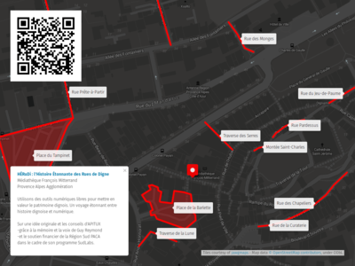
- --Apitux (talk) 14:50, 24 November 2019 (UTC)
- User:Jouski improved the english version of the caption:
- "Let’s use free and open-source digital tools to highlight Digne’s cultural history. A compelling virtual journey through Digne’s past. Taken from an original idea of APITUX along with their guidance—thanks to Guy Reymond’s expertise—and the financial support of Sud Région PACA as part of its SudLabs program."free and open-source digital tools to highlight Digne’s cultural history. A compelling virtual journey through Digne’s past. Taken from an original idea of APITUX"
- --Apitux (talk) 05:46, 25 November 2019 (UTC)
- OK I understand better now. I think a caption like this would explain it
- "A customized map with linked audio descriptions highlighting the cultural history of the town of Digne in France."
- But did you notice the map currently links a lot of "Not Found" audio files? Do you want to fix that before featuring it?
- -- Harry Wood (talk) 22:55, 1 December 2019 (UTC)
