Sr:Using OpenStreetMap

Представљамо нека од упутстава како како можеш да користиш ОпенСтритМап. Ово је отворен пројекат, тако да можеш слободно да откриваш нове начине коришћења који овде још нису наведени!
Ако тражиш одређени сервис који је спреман за употребу и заснован на ОпенСтритМап-у, или желиш да видиш преглед онога што су људи већ радили са ОСМ-ом, посети Примена ОпенСтритМап-а.
Постоји посебна страница о томе како користити ОпенСтритМап без интернет везе.
Лиценца и безбедносно одрицање
Можеш да користиш ОпенСтритМап картирање и податке без надокнаде али под два услова; под један, да attribute your use of OpenStreetMap|наведеш да користиш ОпенСтритМап и под два, да поделиш исправке и побољшања са пројектом односно заједницом. Погледај: Copyright
ОпенСтритМап није потпуна или прецизна карта света и не треба је користити на начин на који недостаци, пропусти, нетачности или грешке могу довести до смрти, губитка или повреде. Погледај: Одрицање.
Карте

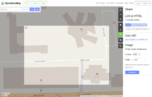
Да направиш тренутни снимак са ОпенСтритМап-а world map|карте света као слику, користи export function|извозну функцију.
Карте на твом веб сајту
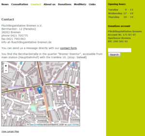
Можеш да користиш ОпенСтритМап карту света н асвом веб сајту, било као static map image|статичку слику карте или као усађени HTML. Ако правиш своју клизећу карту, она може да буде много прилагођенија.
Карте на твом ГПС уређају
Ако желиш да имаш карту засновану на ОпенСтритМап на свом ГПС уређају, посети ГПС карте од ОСМ података или ОСМ карта на Гармину за Гармин уређаје.
Без интернет везе
Погледај ОпенСтритМап без интернет везе.
Направи своју карту
Да направиш своју карту, треба много више да се удубиш. Одељак Software development|Програмска подршка садржи више детаља.
3Д карте
Можеш да добијеш тродимензионални модел града са ОпенСтритМап.
ГИС програмска подршка
- Главни чланак: ГИС програми
Покушавамо да документујемо сваки вид сарадње између ОСМ-а и ГИС програма. Try a search with the form on the top right of this page for your particular GIS software, or browse our GIS software category (use Category:Software as long as the previous doesn't exist). There is also open source GIS software working together with OpenStreetMap.
There is also a whole bunch of tools converting map data from/ to OpenStreetMap data, including support for the popular ESRI Shapefiles and PostGIS format.
It is possible to download portions of OpenStreetMap's raw data (in .osm) that be can exported to a wide variety of formats (including SHP, POSTGIS, geojson) for many purposes, including use in professional GIS software.
Развој програмске подршке

There are general help pages for software developers using OpenStreetMap:
- Rendering and searching in the database are basic tasks using OpenStreetMap's data.
- People shared their Frameworks and explained how to deal with databases.
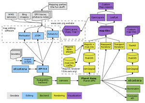
- It may be helpful to learn how the OpenStreetMap software works.
- Read up on the XML schema and Data Primitives if you want to work on data-related tasks.
- Also, OpenStreetMap runs on a relatively small server deployment for its size - see our notes on server hardware for details. There are also API v0.6 mirrors and Dev and Test APIs which help with testing code that interacts with the OSM API.
- switch2osm.org explains how to make the switch from other data services than OpenStreetMap.
If you have questions, ideas or just want to meet fellow developers, contact the OpenStreetMap development community. We also listed some books related to software development with OpenStreetMap.
To see what already exists, visit the List of OSM based Services,the list of companies who offer commercial OSM Software and Services and the list of research about software.
You may also wish to see the list of other projects collecting free geodata.
Примена на вебу
Developers that want to use OpenStreetMap in their web applications can see the list of JavaScript libraries. There are additional libraries in other programming languages. Deploying your own Slippy Map lists corresponding JavaScript libraries and Content Management Systems supporting OpenStreetMap. Maybe you need WMS and TMS, or to create your own tiles.
Рачунање пуртање (Рутирање)
- Главни чланак: Routing#Developers.
3Д
- Главни чланак: 3D Development
Образовање

- Главни чланак: Education
OpenStreetMap has created a unique curriculum that is focused on introducing the topics that OSM addresses: mapping, open source technologies, crowd sourcing and community efforts. It is geared towards university level students. Further, OpenStreetMap has several open problems which would make good student projects. These are items that need researching and "longer-term" issues which could be worked on by students as a project separate from the the core open source development progress happening within the community.
Истраживање
- Главни чланак: Research
At the conference SotM-EU 2011, Muki Haklay gave a talk with advice to academics interested in OSM and the video is available online. We collected a lot of research about OpenStreetMap, but the section research using OpenStreetMap is still empty. Maybe you can fill in something?
Остали извори
На страницама на немачком и енглеском језику можете наћи више информација на ову тему.
