Sv:Tag:junction=roundabout
| Beskrivning |
|---|
| En cirkelformad vägkorsning där trafiken som befinner sig i cirkulationsplatsen har företräde. |
| Grupp: vägar |
| Element för användning |
| Innebär alltid |
|
| Användbara kombinationer |
| Se även |
| Status: de facto |
| Verktyg för den här taggen |
If you understand the original in English, please help completing this Swedish translation. Read the instructions about how to translate this wiki.
No one seems to be working for now on it, you can take this task.
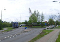
En ![]() cirkulationsplats är en vägkorsning där trafiken färdas kring ett "nav" (t.ex. gräsyta eller liknande) som inte går att köra rakt över. Cirkulationsplatser kan vara små med endast ett körfält med väldigt litet nav eller väldigt stora med flera körfält, t.ex. när de används som del i trafikplatser och sträcker sig över motorvägar.
cirkulationsplats är en vägkorsning där trafiken färdas kring ett "nav" (t.ex. gräsyta eller liknande) som inte går att köra rakt över. Cirkulationsplatser kan vara små med endast ett körfält med väldigt litet nav eller väldigt stora med flera körfält, t.ex. när de används som del i trafikplatser och sträcker sig över motorvägar.
Cirkulationsplatser kallas även "rondeller" trots att en rondell egentligen är det nav som finns i mitten av cirkulationsplatsen.
Var noga med att inte blanda ihop cirkulationsplatser med "mini-roundabouts" (cirkulationsplats där navet går att köra över), vändplaner och andra cirkulära vägformer.
Kartera cirkulationsplatser
- Cirkulationsplatser representeras i OSM genom en sammanhängande väg eller flera sammanhängande vägsegment.
- Samtliga vägar som ingår i cirkulationsplatsen (ej tillfartsvägarna) taggas med junction=roundabout.
- Vägen måste ritas i den riktning som trafiken färdas, dvs motsols i länder med högertrafik.
- oneway=yes behöver ej anges då en cirkulationsplats per definition är enkelriktad.
- Cirkulationsplatsen skall använda den högsta märkningen (t.ex. trunk/secondary/residential) som finns representerad bland de vägar som passerar genom cirkulationsplatsen. Se exempel längre ned.
- Vägar som ansluter till cirkulationsplatsen ritas med endera en eller flera vägbanor beroende på hur det ser ut i verkligheten. Om en väg delar sig innan cirkulationsplatsen så skall de båda anslutningarna taggas med oneway=yes.
- Se till så att inte flera vägar som ansluter till en cirkulationsplats delar samma nod då detta ger problem med körinstruktioner, se Undvik felaktiga körinstruktioner.
- Om cirkulationsplatsen har ett namn så anges det genom name=*. Eftersom fler än en väg passerar genom cirkulationsplatsen ska anslutande vägars namn inte anges för cirkulationsplatsen.
Editor support for circles
JOSM
There exist two ways to draw a circle in JOSM:
- Draw a closed way and press the key O or select Tools -> Align Nodes in a Circle in the menu
- Select two or three nodes (e.g. ending nodes of ways leading to a roundabout) and press ⇧ Shift+O or select Tools -> Create Circle in the menu
Potlatch 2
In Potlatch 2, draw a closed way with at least three nodes and use Align in a Circle in the toolbar.
iD
In iD, first draw a closed way. Then select the way and press the key O, or select the way and click the button that has an image of a closed way on it (labeled "Make this line circular" when you hover over it) in the curved grey contextual menu.
Exempel
Skyltar
Cirkulationsplatser skyltas vanligtvis med någon av följande skyltar:

|

|

|

|

|

|

|
Cirkulationsplatser
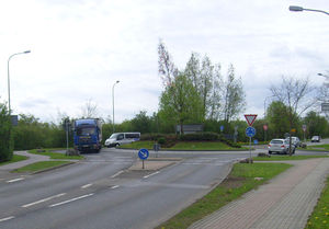
I tabellen nedna visas några exempel på cirkulationsplatser.
|

|

|

|
highway=* junction=roundabout |

|
|---|---|---|

|

|

|
Att välja rätt vägklass
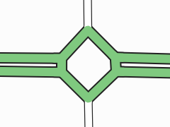
För att välja korrekt märkning av highway=* på cirkulationsplatsens väg så kan nedanstående lathund användas. Grundregeln är att den högst klassade vägen som passerar cirkulationsplatsen används som måttstock.
| Bild | Highway-tagg | Förutsättningar | Beskrivning |
|---|---|---|---|
|
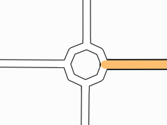
highway=trunk | En väg med separata körbanor och märkningen "trunk" passerar genom cirkulationsplatsen och två vägar med märkning "unclassified" ansluter till den. | Vägen märkt som "trunk" har högst klassning och cirkulationsplatsen taggas med highway=trunk. Notera även att respektive körbana har en egen anslutning till cirkulationsplatsen. |
|
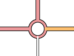
highway=unclassified | En väg märkt med "secondary" slutar vid cirkulationsplatsen. Övriga anslutande vägar är märkta "unclassified". | Vägen märkt "secondary" har högst klassning men slutar vid cirkulationsplatsen. Vägarna som passerar genom cirkulationsplatsen är "unclassified" och därför blir även cirkulationsplatsen "unclassified". |
|
highway=primary | En väg märkt med "primary" ansluter till cirkulationsplatsen från väst och nord. En väg märkt "secondary" ansluter från öst och en väg märkt "service" från syd. | Vägen märkt "primary" har högst klassning och passerar igenom cirkulationsplatsen, således märks cirkulationsplatsen med "primary". |
Undvik felaktiga körinstruktioner
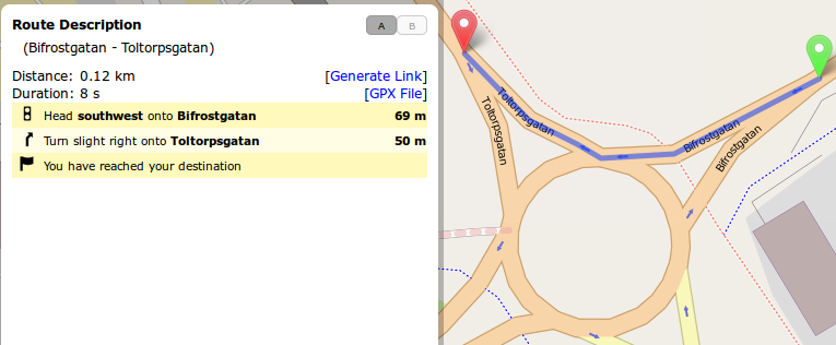
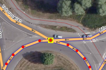
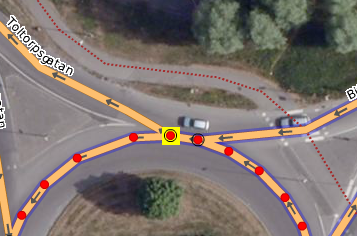
För att programvaror som ger körinstruktioner (t.ex. en bilnavigator eller en fristående GPS-applikation) ska kunna ge korrekta instruktioner så krävs det att samtliga vägar som ansluter till en cirkulationsplats gör det i egna noder. Nedan visas ett exempel på hur felaktig kartering leder till att instruktion för cirkulationsplatsen uteblir.
Utsnitt från Potlatch 2 för samma cirkulationsplats
Utsnitt från Potlatch 2 för samma cirkulationsplats där felet åtgärdats
Tvetydigheter
In OpenStreetMap we have several tags that describe different circular and widened road features.
- junction=roundabout for roundabouts;
- highway=mini_roundabout for mini-roundabouts;
- junction=circular for rotaries (traffic circles) and other circular traffic that is not a roundabout;
- highway=turning_circle for turning circles;
- highway=turning_loop for turning loops;
- highway=passing_place for road passing places; and
- traffic_calming=island for islands meant to calm traffic.
The major differences between the first four are:
- A roundabout is a one-way street with right-of-way and a non-traversable centre island. There can be traffic light, as long as the circular road has right-of-way when the lights are off.
- A mini-roundabout is a one-way street with right-of-way and a traversable centre island. In particular, large vehicles are allowed to drive across the centre island if otherwise not possible due to their dimensions, i.e. it might be impossible for a large vehicle to drive through a roundabout but possible to drive through a mini-roundabout with the same dimensions.
- A circular junction is a one-way street around a non-traversable centre island, however the circular traffic has not always the right-of-way, it has to yield at some or all incoming roads. This includes traffic circles with such yield regulations as perceived in the United States.
- A turning circle is a widened space on a two-way street without any centre island (or at least a fully traversable island). The absence of a centre island allows also large vehicles to turn around.
Why is it important to follow this tagging guideline if the map looks good even when tagged differently?
The map is not everything. There exist a lot more applications which process our data and these tags have different implications e.g. for routers. So if you tag a small roundabout as a mini-roundabout or a loop at the end of a street as a turning circle, it might look ok on the map but will break other applications. So please don't think of this as annoyance and try to use the most fitting tags in each situation.
The following table presents the preferred tagging for the most common situations and also tries to clarify some ambiguities.
| Photo | Tagging | Remarks |
|---|---|---|

|
highway=* junction=roundabout |
A standard roundabout with a large, non-traversable centre island. |

|
highway=* junction=roundabout
|
Small, but not a mini-roundabout. Although it is preferred to tag this the same way as a large roundabout, for the sake of simplicity it is acceptable to tag this with a single node with junction=roundabout. In this case the tag direction=* should be specified, as its default value is anti-clockwise when used in conjunction with a roundabout. |
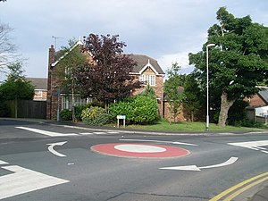
|
highway=mini_roundabout direction=clockwise |
A classical mini-roundabout where the centre is only a painted circle. The tag direction=* should be specified, as its default value is anti-clockwise when used in conjunction with a mini-roundabout. |
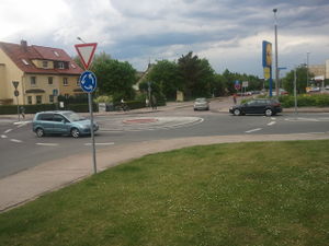
|
highway=mini_roundabout |
Large, but a mini-roundabout. The centre island is traversable and without signposts. |
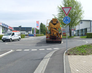
|
highway=mini_roundabout |
Also a classical mini-roundabout with a slightly raised but still fully traversable centre island. |
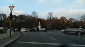
|
junction=circular |
Traffic routed in a circle, with a large, non-traversable centre island. However the circular traffic must yield for at least one, some or each entering road, thus not a roundabout. |
|
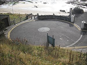
highway=turning_circle |
This photo shows a round place with a traversable island in the middle, but this is neither a mini-roundabout nor a roundabout, but instead a turning circle, which allows large vehicles to turn around. Please bear in mind that a turning circle can have any shape, but never a non-traversable island. |
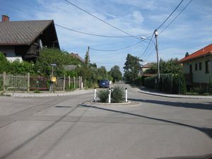
|
There are no indications of right-of-way, so this is a circular junction rather than a roundabout. There are no one-way indications, so the circular way should be tagged oneway=no. | |
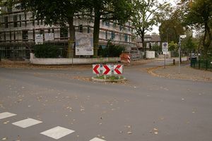
|
This is also a circular junction with traffic calming. Watch the arrows closely to figure out whether to tag the circular way with oneway=yes or oneway=no. | |

|
or alternatively proposed
|
Obviously a place for vehicles to turn around. But because of the island, it is not a turning circle (which must not have an island), so this should be mapped as a loop. For the sake of simplicity the tag highway=turning_loop on a single node is currently under discussion. |
Signalkontrollerade cirkulationsplatser
Many roundabouts with heavy traffic are modified with traffic signals controlling traffic on the roundabout itself. Traffic joining the roundabout may not have to obey standard rules of priority at some entrances to the roundabout because of the signalling. In many cases some entry roads (those with lighter traffic) on these roundabouts are not signal controlled so that the whole junction still behaves as a roundabout (e.g., http://osm.org/go/eu5aUXR98--). Even when all junctions are signal-controlled, it is suggested that junction=roundabout be retained.
Relaterade taggar
Se även
- Wikipedia article about roundabouts
- UK Highways Agency Design Manual for Roads and Bridges - Volume 6, Section 2, Part 3: Geometric Design of Roundabouts
- US Federal Highway Administration Safety Program - Technical Summary - Roundabouts
- How to change an intersection into a roundabout in JOSM
- Proposal to group the ways and/or nodes comprising a road junction
- Wikipedia article about traffic circles
