Malaysia
| V・T・E |
| latitude: 4.204, longitude: 109.171 |
| Browse map of Malaysia 4°12′14.40″ N, 109°10′15.60″ E |
| Edit map |
|
External links:
|
| Use this template for your locality |
Malaysia is a country in Southeast Asia at latitude 4°12′14.40″ North, longitude 109°10′15.60″ East.
Welcome
Hello and welcome to the Malaysia mapping project!
New to OpenStreetMap? You may find that the Beginners' Guide is useful as a stepping stone to further get involved in OpenStreetMap.
Questions? Discussions? You are invited to join the official OpenStreetMap community forum. The Malaysian community forum is also there, so feel free to post anything related (not spam though). In addition, OpenStreetMap Q&A based help forum is another channel to get a fast response. There exists a Telegram group for informal public chat/discussion on mapping/using OpenStreetMap for Malaysia.
This page roughly gives some hint about the specific ways to tag a lot of stuff in the Malaysian context. To maintain the map quality over Malaysia with respect to the rest of the world, there should be some sort of convention. Any constructive feedback is really appreciated, do speak your mind in the Malaysian community forum!
 |
Penutur bahasa Melayu? |
| Jemput ke halaman Wiki OpenStreetMap yang diterjemahkan dalam bahasa Melayu. |
Conventions
These pages describe the conventions to tag Malaysian highways, waterways, names, etc.
- Malaysian Roads Tagging
- Penang Editing Guide
- Other tagging aspects i.e. names and waterways.
- Bus Routes in Malaysia (Klang Valley)
- Power infrastructure
How to map a place name? Easy. Just describe the place, as shown on erected signs! Not sure what the name is? Leave it blank - no need to make up for it! The description of the points themselves will do their work!
Data Sources
- For more details on this topic, see Malaysia/Data Sources and Contribute map data.
As a kind reminder, besides your knowledge, these are the other sources that can be used to put data into OpenStreetMap.
Permitted data sources
Please make full use of anything that comes with the editor. It doesn't hurt to read more about these, in fact, it may help you save a lot of time in the future.
- Tracing layer: Bing, Mapbox and Esri. This screen capture shows you how.
- Available street level photos from Mapillary, KartaView or to a lesser extent, Bing StreetSide. Dear Organised Editing Teams, it is really advisable to check for these street level photos first, before making edits that can be considered quite mindlessly.
- GPS tracks from public OpenStreetMap GPS tracks. Enable OpenStreetMap GPS traces in the background menu.
Forbidden data sources

DO NOT copy from these sources - even names of things! This can lead to troubles like this. Anything that says something like "copyright reserved" is definitely not OK.
- Google Maps, Google Satellite, Google Earth and Google Street View[1][2]
- The Copyright infringement section in the Copyright link on the main page has explicitly mentioned that
OSM contributors are reminded never to add data from any copyrighted sources (e.g. Google Maps or printed maps) without explicit permission from the copyright holders.
- Non-exhaustive links about Google:
- The Copyright infringement section in the Copyright link on the main page has explicitly mentioned that
- Waze[3]
- HERE Maps[4]
- Wikipedia and Wikidata[5][6][7]
- Wikimapia[8]
- Malfreemaps[9] or Malsingmaps[10]
We can use satellite imagery provided by Bing, but please do not copy map data (such as name of roads and places) from Bing Maps!
Routable Maps of Malaysia
Some (third-party) apps do offer offline routing for Malaysia. For example: MAPS.ME and OsmAnd apps which is available for both Android and iOS platforms.
Those who fancy online maps might want to check out Open Source Routing Machine; (wiki) which updates every 12 hours, Mapcat (wiki) or even Mapquest (wiki).
For Garmin devices, options such as Lambertus's routable maps for Garmin devices is a thing. Osm2mp converts OpenStreetMap data into Polish map format (MP). mkgmap (Mkgmap wiki) converts OpenStreetMap data into Garmin img map (IMG). Read more about OSM Map On Garmin.
Kaart Groundwork & Editing
Kaart conducts ground surveys for improvements to OSM data. A list of editors can be found on the Kaart wiki page.
- Mapillary imagery from the Malaysia drives can be viewed here.
Malaysia (January, 2020)
Regions
The regions mapped included Kuala Lumpur, George Town, and Johor Bahru.
Ground Focus
- The primary focus for ground surveys is adding street names, missing geometry, and one-ways.
Post Processing
- After the ground survey has been conducted, our office team focuses on reviewing the footage gathered and updating street names by integrating the current data and physical road signs.
- The team adds turn restrictions, barriers, pedestrian crossings, ref tags, surfaces to roads, lanes, classifications, destination tags, and additional missing geometry.
Suggested Community Edits
- After incorporating the available data from the ground survey and processing the footage we will compile suggested edits for the region.
The ground survey of Malaysia was conducted by Kaart Team members Soccersweeper, ImjusBuddy, Velocimaptor, CoolGuyJake, Cinderblock, Dalekokarta, rallynukab and Corban8.
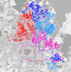
 [1] Tracks driven during Kaart's ground survey in Kuala Lumpur. Imagery provided by Bing. |
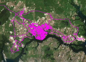
 [2] Tracks driven during Kaart's ground survey in George Town. Imagery provided by Bing. |
 [3] Tracks driven during Kaart's ground survey in Johor Bahru. Imagery provided by Bing. |
Resources and external links
Wikipedia
 Roads in Malaysia
 Malaysian Expressway System
 List of expressways and highways in Malaysia
 Malaysian Federal Roads system
 Malaysian State Roads system
 Road signs in Malaysia
 National speed limit
- Malaysia GPS Trace
- OSM Mapper - keep track of edit sessions on your areas
Recommended readings
The followings are recommended readings for everyone
- Map Making Overview
- Map Features
- Editing Standards and Conventions
- Mapping techniques
- Sample areas, Karlsruhe Schema
- Potlatch, JOSM, Maperitive, Osmosis
- Routing, OSM tags for routing, JOSM Relations and Turn Based Restrictions
- Neat Stuff
Other crowdsource mapping communities in Malaysia
- Malfreemaps - Malaysia and Singapore free [Garmin] maps project
- Malsingmaps - [Garmin] GPS Portal of Malaysia and Singapore
References
- ↑ Showing redaction "Google as a source"
- ↑ Showing redaction "Google Street View"
- ↑ Waze Terms of Use. Refer to the USE RESTRICTIONS section.
- ↑ 2a. Can I trace data from Google Maps/Nokia Maps/...? section of the Legal FAQ.
- ↑ Importing geodata from Wikipedia
- ↑ [OSM-talk] Redactions in North Korea
- ↑ Importing data from Wikidata into OSM
- ↑ Putting OSM data into wikimapia is not allowed
- ↑ About Malfreemaps - license incompatibility
- ↑ Malsingmaps copyright notice - Malsingmaps is for personal use only

