Colombia/Project/Ciclovías
This document describes how to map the cycleways (called ciclovías in Colombia) initially created in Bogota, then replicated to other Colombian cities in which this same activity now takes place. This project includes all the detours and turn restrictions used, affecting the different types of vehicles which has all been added onto OSM.
Colombian cities where this project has already been applied:
- Bogota (es)
- Medellin (es)
- Villavicencio (es)
The Spanish version of this article may show more recent updates.
Ciclovías description
Definition as found on the Bogota Mayor's Office website:
"The Bogota Ciclovía currently provides its service between 07:00 am and 02:00 pm, during Sundays and holidays year-round throughout the main roads of the city, joining all segments together now form a 127.69 kilometer long circuit covering all sectors around the city."[1]
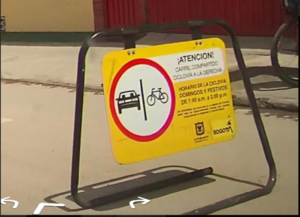
The ciclovías, or as some may call this concept in English, "Open Streets" is an activity originated in Bogota in the 70's, based on similar experiences as seen in a other few cities around the world. The ciclovías in Bogotá are currently used by an average of 1.5 million people every week with free access to over (recently expanded to) 138 km of "shut-down to other motor vehicle traffic" roads. This same concept has already been applied in other cities and smaller towns throughout the rest of Colombia, as well as in many other cities and countries around the world.
There are several different terms in Bogota applied to the cycleways[2]:
- Ciclovía: Found on main roads that are normally used for regular automotive traffic, on which the use of motor vehicles is restricted on Sundays and holidays during well defined morning hours, allowing pedestrians to participate in outdoor activities, such as riding a bicycle, walking or jogging. These are usually very well marked with road signs deterring other traffic from accessing these roads during the time this activity takes place. These must be entered by the proper use of (restriction:conditional) tags on otherwise normal streets.
- Cycle path/Ciclorruta: A permanent path used for bicycles or the like. These usually have some sort of obstacle or barrier which in certain cases may be shared ways with pedestrians. If any physical barrier is present, these may be drawn in as entirely separate ways, OR if the path faithfully follows the same road used by other vehicles, it may be also entered by using the proper road tagging:
- Bicycle lane/bicicarril: A permanently marked bicycle lane or similar, on what was previously a "car lane" and has been designated for bicyle use, usually only marked by painted signage. These are to be entered with the proper use of (restriction:conditional) tags only (and not to be drawn-in separately).
- Shared bike lane/Ciclorruta compartida: A normal car (or bus) lane(s), where bicycles usually have priority over all other vehicles; usually indicated with painted signs. These are to be entered by the proper use of (restriction:conditional) tags only (andnot to be drawn in separately).
Sections
The ciclovía in Bogotá has been divided into 3 major sections, each one being formed by several sub-sections:
- Norte - North
- N1 - Boyacá Norte.
- N2 - Avenida Pepe Sierra and Avenida Córdoba.
- N3 - Carrera 7 Norte.
- N4 - Carrera 9, Calle 147 and Calle 170.
- N5 - Carrera 60 and Calle 72.
- Centro - Center
- C1 - Boyacá Sur.
- C2 - Carrera 50.
- C3 -Carrera 7 and Carrera 6 Sur.
- C4 - Calle 26 Oriental.
- C5 - Calle 26 Occidental.
- C6 - Parkway and Parque Nacional.
- Sur - South
- S1 - Bosa Soacha connection.
- S2 - Yomasa.
- S3 - Calle 17 Sur and Calle 39 Sur.
- S4 - Carrera 24.
- S5 - Avenida Guayacanes.
Ciclovías Map
The Bogota Ciclovia map is visible here in IDRD.
Mapping
In order to start mapping the ciclovías the first step involved creating a relation to include all the different road segments of the highways this covered. During the ciclovía's timeframe, no other motor vehicle traffic is allowed to drive on any of the roads (or road segments) included on these roads. Each specific case, on which these restrictions were aplicable to the entire road segments, or vehicle type access restrictions to specific lanes only.
The rest of the tagging is to be applied to objects impacted by detours, or turn restrictions.
Since multiple tagging suffixes are being used, the JOSM editor will currently generate validation alerts, which can be ignored. This is due to JOSM does not recognizing some of the tag combinations we are using for this. However, they have already been consulted with various people within the community, so they are valid by a general consensus.
Cyclable sections
Relations
In order to map the ciclovías in Bogotá, the following tags are to be used within a relation.
For the elements/objects which form a part of the relation, please check the "Individual highway segments" section.
- Generic:
name=*- The name of the ciclovía without abbreviations. For example: Ciclovía Avenida Pepe Sierra - Avenida Córdoba. It is preceded with the word "Ciclovía" followed by the ciclovía code provided by the IDRD, followed by a hyphen, then finilazing with the name of the ciclovía.route=bicycle- Element of the relation.type=route- Relation type.
- Ciclovía values:
network=lcn- The type of local ciclovía network.operator=IDRD- Being this the entity responsible of controlling access only for bicycles and pedestrians during the ciclovía time period.ref=*- on the IDRD page you can consult the codes for each ciclovía segment, which were previously listed in this article.
To see the sections already mapped, the following query can be used: https://overpass-turbo.eu/s/1fnR.
Individual highway segments
A ciclovía relation is formed by several normal highway segments on which the ciclovía goes on (nor the detours, nor any turn restrictions derived from this activity form a part of the ciclovía relation). This following list covers all of the tags to be used on road segments where access to motor vehicles is temporarily restricted and are, in turn, allowed to be used exclusively by bicycles and pedestrians (understanding that these restrictions may apply to complete road segments, or be limited to one or more lanes). These road segments should be mapped as follows:
- Generic values for highways
- Car access restrictions:
motor_vehicle:conditional=no @ (Su,PH 07:00-14:00)bicycle:conditional=yes @ (Su,PH 07:00-14:00)foot:conditional=yes @ (Su,PH 07:00-14:00)oneway:bicycle:conditional=no @ (Su,PH 07:00-14:00)- Restrictions when the highway is shared between cars and ciclovía:
bicycle:conditional=yes @ (Su,PH 07:00-14:00)
- On oneway highways:
- On oneway highways, which convert into 2-way (for bicycles and pedestrians, in this particular case) during :
oneway:bicycle:conditional|no @ (Su,PH 07:00-14:00)oneway:lanes:conditional=yes|no @ (Su,PH 07:00-14:00)
Vehicle diversion/detour sections
The affected highway sections where there are car detours should have these tags:
- Generic values for highways:
- Restriction, however depending on the cases of the next section, this could be different.
motor_vehicle:conditional=yes @ (Su,PH 07:00-14:00)Restrictions per lanes, for examples when one lanes goes the other direction during ciclovía:oneway:lanes:conditional=yes|-1 @ (Su,PH 07:00-14:00)
Turning restrictions
Roads that lead to or cross a ciclovía must be modified to include turning restrictions. In order to be able to map the segments correctly, it is recommended to split the road segments, at most up to the previous or next corner of the restriction node. This prevents to have relation members that span several blocks, which, if modified, can damage the constraint. These restrictions may seem somewhat redundant and unnecessary, but they strengthen the mapping of the ciclovía, and prevent routers from generating a route through the ciclovía corridors during their schedule.
- No right turn. This is the most frequent case, and applies to any street that leads to the ciclovía. In this case, it should be stated that you cannot turn right during ciclovía hours.
- Relationship:
- Members:
- From: The road that ends or crosses the ciclovía.
- Via: The node that shares the from with the ciclovía.
- To: Ciclovía segment.
- Example: Carrera 12 with Calle 147.
- No left turn. Occurs on one-way roads that normally allow left turns.
- Relationship:
- Members:
- From: The road that ends or crosses the ciclovía. This route is normally one way.
- Via: The node that shares the from with the ciclovía.
- To: Ciclovía segment.
- Example: Carrera 13 on Calle 147.
- Just go straight. This is to reinforce the mapping and prevent the routing system from offering the option of turning cars during the ciclovía.
- Relationship:
- Members:
- From: Origin street, which allows turning when there is no ciclovía.
- Via: Node union.
- To: The ciclovía.
- Example: Carrera 12 with Calle 147.
- You cannot go straight. Applies to car lanes that cannot continue because they become ciclovía.
- Relationship:
- Members:
- From: Origin street.
- Via: Node union.
- To: The ciclovía.
- Example: Calle 147 coming up from the highway on Carrera 19.
- Only turn right. Applies to carriageways that can go straight or turn right
- Relationship:
- Members:
- From: Shared street between ciclovía and cars.
- Via: Node union.
- To: Road that leaves the ciclovía.
- Example: Carrera 9 exiting at 147th Street. Links (entrances) to ciclovía.
- Link-type roads that reach a ciclovía must be marked with
motor_vehicle:conditional=no @ (Su,PH 07:00-14:00), which avoids being used during the ciclovía.
Guidelines
As part of this project, these mapping guidelines or assumptions have been made:
- When a lane of the road is shared between ciclovía and cars, said lane:
- It is one way if it has a different entrance and exit. For example, you enter this lane at one corner, and exit at the next corner.
- It is two-way if the entrance and exit are the same, and your destination is a gas station, parking lot, etc.
- All roads that lead to a ciclovías must have a turn restriction.
Mapping issues (Cases)
(This wiki table can be edited here)
| Títulos y breves descripciones
Name & brief descriptions |
ESTADO NORMAL (Ciclovía INACTIVA: Lunes a Sábado)
NORMAL STATUS (Ciclovía INACTIVE: Monday through Saturday) |
ESTADO TEMPORAL (Ciclovía ACTIVA: Domingo AM & Feriados públicos)
TEMPORARY STATUS (Ciclovía ACTIVE: Sunday mornings & public holidays) |
Etiquetas requeridas para activar la Ciclovía
Tags required to temporarily activate the Ciclovía |
Ejemplos de imágenes
Imagery Examples |
|---|---|---|---|---|
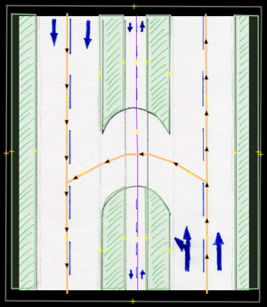
1. Sin cambios a rutas para vehículos_motorizados. (Este ejemplo NO muestra las Ciclovías activadas)
1. Without any motor_vehicle route changes. (This example DOES NOT depict the Ciclovías activity)
|
 |
 |
Descrito (durante de actividad en las Ciclovías) en las calzadas de izquierda a derecha.
Described (during the Ciclovías activity) from left to right side carriageways
Calzada Izquierda / Left Carriageway Divisor Central / Central Divider Calzada Derecha / Right carriageway |
Calle 170, que usa la cicloruta actual / Calle 170 intersecting with cycleway. |
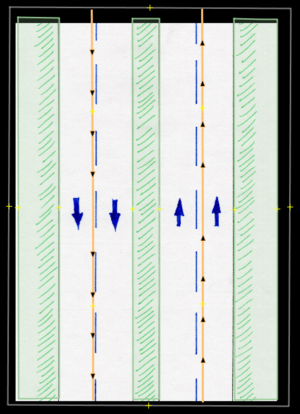
2. Calzada lado derecho con acceso restringido para vehículos_motorizados.
2. Restricted motor_vehicle access on right-hand side carriageway.
|
 |
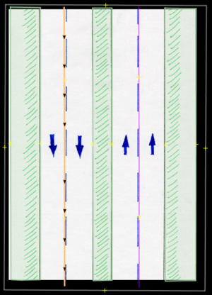 |
Descrito (durante de actividad en las Ciclovías) en las calzadas de izquierda a derecha.
Described (during the Ciclovías activity) from left to right side carriageways. Calzada Izquierda / Left Carriageway Right Carriageway |
Avenida Córdoba (Avenida Carrera 55). |
3. Acceso restringido para vehículos motorizados en calzada derecha + calzada izquierda es convertida a doble sentido.
3. Restricted motor_vehicle access on right side carriageway + left side carriageway becomes 2-way for motor_vehicles.
|
 |
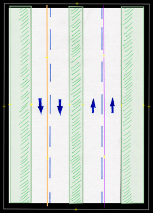 |
Descrito (durante de actividad en las Ciclovías) en las calzadas de izquierda a derecha. /
Described (during the Ciclovías activity) from left to right side carriageways. Calzada Izquierda / Left Carriageway Right Carriageway |
Puente Calle 116 con Autopista. |
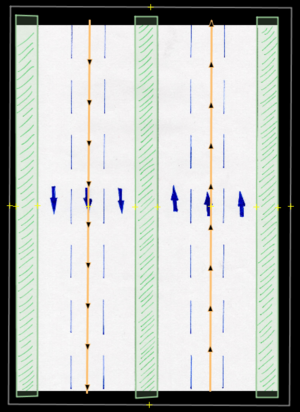
4. Acceso parcialmente restringido para vehículos_motorizados.
4. Partial restricted access to motor_vehicles.
|
 |
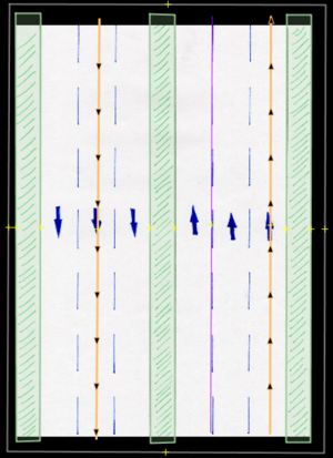 |
Descrito (durante de actividad en las Ciclovías) en las calzadas de izquierda a derecha. /
Described (during the Ciclovías activity) from left to right side carriageways. Calzada Izquierda / Left Carriageway Right Carriageway
|
Estación de gasolina sobre la 116 cerca de la Boyacá. |
5. Acceso parcialmente restringido para vehículos_motorizados.
5. Partially restricted access to motor_vehicles.
|
 |
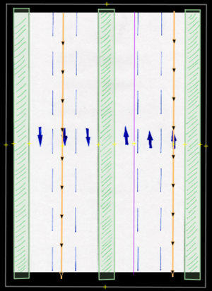 |
Descrito (durante de actividad en las Ciclovías) en las calzadas de izquierda a derecha. /
Described (during the Ciclovías activity) from left to right side carriageways. Calzada Izquierda / Left Carriageway Right Carriageway
|
Tramo de vía para entrada/salida conjunto residencial Calle 116 con Avenida Córdoba / Road segment for entry/exit to residential building on Calle 116 & Avenida Córdoba (Avenida Carrera 55)
UBICACIÓN en OSM / LOCATION on OSM DOES THIS IMAGE REALLY APPLY TO THIS CASE? |
| 5a. 2 carriles con acceso restringida de vehículos_motorizados - Solo accesibles a bicicletas y peatones + vehículos_motorizados pueden circular en "doble-sentido".
5a. 2 Lanes with restricted access to motor_vehicles - Only accesible to bicycles & pedestrians + motor_vehicle permissible to transit 2 ways. |
 |
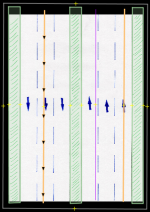 |
Descrito (durante de actividad en las Ciclovías) en las calzadas de izquierda a derecha. /
Described (during the Ciclovías activity) from left to right side carriageways. Calzada Izquierda / Left Carriageway Right Carriageway
|
Tramo de vía de acceso y salida a la estación de servicio ubicada sobre la Carrera 7, entre las calles 59 y 60. / Road segment for entry and exit to the gas station located on Carrera 7, between 59th Street and 60th Street. |
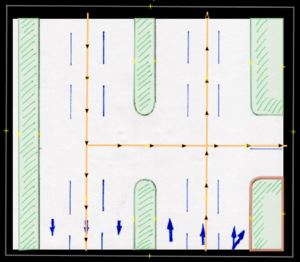
| 6. Giro a la derecha atravesando la ciclovía.
6. Right-hand turn going through the ciclovía. |
 |
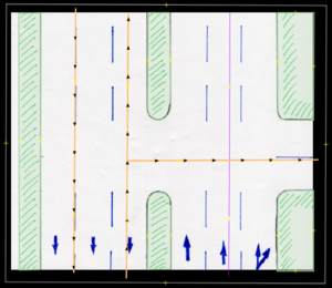 |
Descrito (durante de actividad en las Ciclovías) en las calzadas de izquierda a derecha. /
Described (during the Ciclovías activity) from left to right side carriageways. Calzada Izquierda / Left Carriageway
Right Carriageway Horizontal connecting way has NO changes. |
Calle 116 con Carrera 53 |
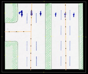
| 7.
7. Left-hand turn becomes permissive to motor_vehicles moving Northward. |
 |
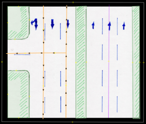 |
Descrito (durante de actividad en las Ciclovías) en las calzadas de izquierda a derecha. /
Described (during the Ciclovías activity) from left to right side carriageways. Calzada Izquierda / Left Carriageway
Right Carriageway |
Avenida Boyacá con Calle 164 |
| 8.
8. Ciclovía is on the far right lane ONLY. |
 |
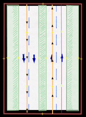 |
Descrito (durante de actividad en las Ciclovías) en las calzadas de izquierda a derecha. /
Described (during the Ciclovías activity) from left to right side carriageways. Calzada Izquierda / Left Carriageway Right Carriageway
|
Calle 116 en dirección a la Avenida Boyacá / Calle 116 heading towards Avenida Boyacá |
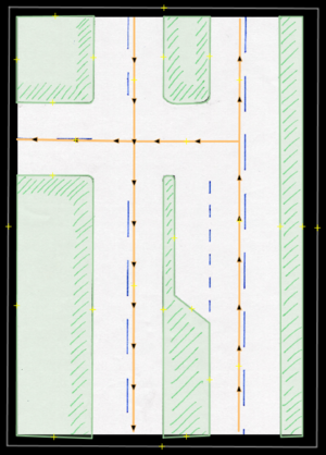
| 9.
9. On the temporary 2-way carriageway, motor_vehicles may cross-over ciclovía to turn left. |
 |
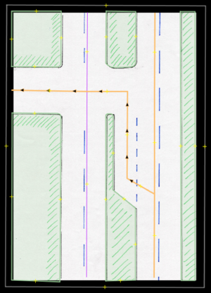 |
Descrito (durante de actividad en las Ciclovías) en las calzadas de izquierda a derecha. /
Described (during the Ciclovías activity) from left to right side carriageways. Calzada Izquierda / Left Carriageway Right Carriageway
| |
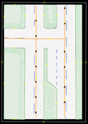
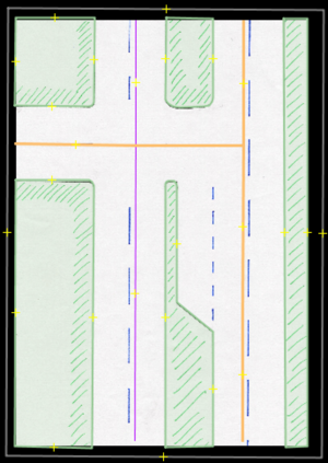
| 9a. Los carros se cruzan antes de la esquina para girar a la izquierda. La otra vía es doble
9a. On the both-ways highway, the cars crosses themselves before turning into the left. The other way is two ways. |
 |
 |
Descrito (durante de actividad en las Ciclovías) en las calzadas de izquierda a derecha. /
Described (during the Ciclovías activity) from left to right side carriageways. Calzada Izquierda / Left Carriageway Superior e inferior / Upper and lower |
Calle 116 con 13. |
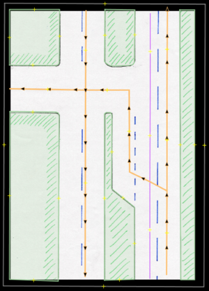
| 10.La Ciclovía se encuentra sobre carril izquierdo y los vehículos_motorizados transitan sobre el carril derecho. Para cruzar desde ese carril, deben cruzarse sobre la ciclovía hacia carril de cruce permitido.
10. Ciclovía is on left lane, motor_vehicles on right lane. But the cars may cross-over the ciclovía in order to turn left. |
 |
 |
Descrito (durante de actividad en las Ciclovías) en las calzadas de izquierda a derecha. /
Described (during the Ciclovías activity) from left to right side carriageways. Calzada Izquierda / Left Carriageway Right Carriageway
|
Avenida Boyacá & Calle 127B. |
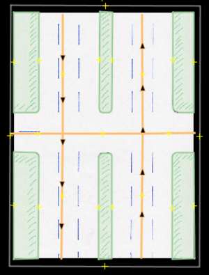
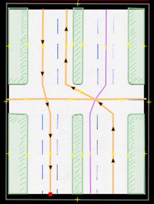
| 11. Desde calzada derecha (2-carriles) se obliga a girar para utilizar la calzada izquierda (1 carril),transicionando a vía de doble sentido temporalmente.
11. Right carriageway (2-lanes) forced to turn onto left carriageway (1-lane), converting it to a temporary 2-way road. |
 |
 |
Calzada Izquierda SUPERIOR / TOP Left Carriageway
Calzada Izquierda INFERIOR / BOTTOM Left Carriageway Calzada derecha SUPERIOR / TOP Right Carriageway Calzada derecha INFERIOR / BOTOM Right Carriageway
|
Avenida Boyacá (Avenida Carrera 72) & Calle 134 |
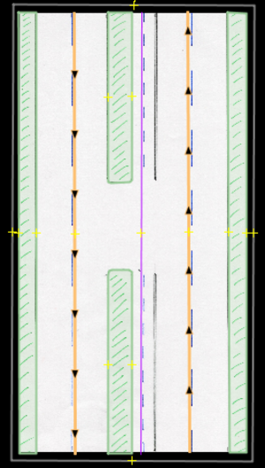
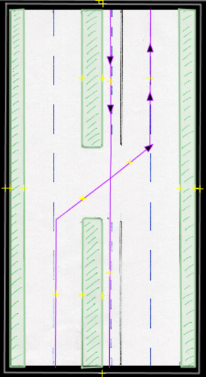
| 12. Cicloruta doble sentido en el centro ahora es de un solo sentido
12. Ciclorruta in the middle-lane is normally a 2-way (for bicycles), becomes a one-way. |
 |
 |
Descrito (durante de actividad en las Ciclovías) en las calzadas de izquierda a derecha.
Described (during the Ciclovías activity) from left to right side carriageways.
|
Carrera 7 & Calle 106 |
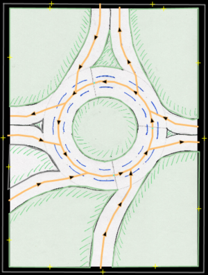
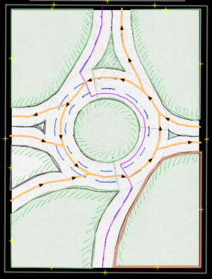
| 13. Glorieta (rotonda) con carril central parcial designado para que bicicletas la utilicen para atravesar.
13. Roundabout with partial center lane implemented for bicycles to cross-over only |
 |
 |
Segmento SUPERIOR / TOP Segment
Segmento GLORIETA / ROUNDABOUT segment
Segmento INFERIOR / BOTTOM segment |
Glorieta calle 100 con NQS, Carrera 15, Carrera 9 / Roundabout connecting Calle 100 w/NQS, Carrera 15, Carrera 9 |
Commits
We are using the following hashtag for all our commits: #CicloviaBogota
We also use as a "source" the following link: https://bit.ly/cicloviaWiki
Methodology
In order to carry out this project, the following steps have been followed:
- Preparation.
- Obtained cycleway maps on the Internet and other relevant information on the local ciclovías.
- Searched for other data sources of ciclovías or detours. In this case, the IDRD map and the IDECA maps.
- Officially requested data from the authorities in charge. A "right to petition" was made to have access to the deviations.
- Riding through the ciclovías on bicycle taking geo-referenced photos. 360 photographs to for a more accurate analysis of the environment.
- Took geo-referenced pictures while driving in a car through the detours caused the cilcovías. In some cases particular mapping conditions can be identified.
- Mapping process.
- Created a master relation, which includes the entire ciclovía network. The ciclovía is divided into 3 sectors (North, Center, South), and each sector is formed by several sub-sectors (all indicated at the beginning of this article). This master relation is composed of other relations. It has no segments as such.
- Selected all the ciclovía segments/ways that form a part of a ciclovía section and created a relation for each. This relation indicates the name of each section.
- Added all required generic tags to all the members of the relations, as if the ciclovía were blocking all the lanes on the entire ciclovía road.
- Made a virtual tour of the "ciclovía" through Mapillary, to identify the particular sections that needed to be mapped.
- Added lanes, directions, and mapping features, as explained above.
- Identify, then match each particular scenario in the described cases and map them accordingly with the pertaining tags. This will require to split ways in the proper location, in order to add the specific tags on only the road segments which require it.
- Take the virtual tour of the "detours", and identify cases.
- Each detour case, will require mapping them according to the cases described above.
- As you work, describe on this Wiki page exactly which segments have been completed, on the following spreadsheets (bellow): Mapped sections.
- Review turn restrictions, and add all conditional restrictions where appropriate.
Mapped sections
=
Post-check
Once the project is finished, it is necessary to ensure that the data is still valid. In order to achieve this, the following queries can be executed in Overpass turbo (example for Bogota) to download the mapped data set.
- Bicycle lane segments - https://overpass-turbo.eu/s/1kRw
- Bicycle lane restrictions - https://overpass-turbo.eu/s/1kRt
With these two queries we can download exactly the map objects modified for this project.
GitHub project
Based on the Overpass queries, a script was created to extract this data from OSM and compare it to a previous version. If there are differences, it emails some people: https://github.com/MaptimeBogota/OSM-elements-change-tracker.
See more
- History of the ciclovía - https://ciclovia.idrd.gov.co/conoce_mas/%e2%80%a2historia-y-evolucion-ciclovia/.
lanes=*and Lanes.- Key:turn
- Key:change
- Files associated with the images in this article and possible cases in JOSM: https://github.com/MaptimeBogota/Varios/tree/main/proyecto-ciclovia.
- Question about case 4 - https://help.openstreetmap.org/questions/83346/mapping-ciclovia-case-4-some-lanes-are-dedicated-for-bikes-some-for-cars.
- Question about case 9 - https://help.openstreetmap.org/questions/83467/mapping-ciclovia-case-9-during-detour-turn-lane-is-not-next-to-forward-lane.
- Question about case 9a - https://help.openstreetmap.org/questions/83560/mapping-ciclovia-case-9a-during-detour-turn-lane-is-not-next-to-forward-lane-leads-to-a-two-way-highway.
- Designated value Tag:access=designated.
- Key:access.
- Conditional restrictions.
- Key:oneway.
- Key:oneway:bicycle.
- Talk:Conditional restrictions#Adding Lanes iteration to Conditional restrictions.23Evaluation of conflicting restrictions.3F.
- This project is already listed in TagInfo.
- Explanation in Wikipedia:
 Ciclovía.
 - Organized activity.
References
- ↑ https://bogota.gov.co/servicios/guia-de-tramites-y-servicios/https-www-idrd -gov-co-ciclovia-bogotana-ciclovia-program
- ↑ https://www.movilidadbogota.gov.co/web/sites/default/files/Paginas/05-10-2020/manual_del_buen_ciclista.pdf