Community Updates/2010-10-25
Community Update From 25 October 2010 to 31 October 2010
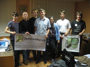
Image Of the Week
Великие Луки Mapping Weekend banner: "We've come from different cities of Russia and Belarus to create the best map of Velikiye Luki in the world"
Project of The Week : Stay a While
Where do you stay when you travel? Sometimes we stay with friends and family and we already have those places mapped. What about hotels, motels, hostels, camp grounds and caravan parks? When we map at home, these amenities for visitors can be invisible to us. Let's turn that around and map the places for visitors in our towns.
News
- New #osm-tagging irc channel on oftc.net
- surface:winter_road is now requesting comments.
- Another OSM book available on amazon and others
- OSM board meeting will now be held at 2100 CET every Wednesday..
Several old_name in one place
Sometimes you want to add more than one old_name=* to a node.
Since the ';' in the value can't handle very well the ordering, someone asks what are the other possibilities to do this.
An useful Comparison of life cycle concepts was given in response.
Software page With a bot
After the rework of the software template on the wiki, Tordanik has work on a automaticaly generated software page with a bot (Warning huge page!). Check the new Software page.
Amenity debate
Amenity his has been choosen historicaly to describe "useful and important facilities for visitors and residents: toilets, telephones, banks, pharmacies (to buy medicines), schools". And has become a huge namespace where tons of things take place. Some proposition has already moved from this namespace to take place in another more appropriate. Since this key is used in 3% of all nodes of the database, some think that this description is not as complete as it should. A big debate about tagging and description started without ending on a real conclusion.
What's the difference between footway and pedestrian
A lot of users get confused when the must choose between highway=footway and highway=pedestrian.
Another definition was given to try to help these users :
footways are generally smaller. pedestrian indicates a road but with limited or no traffic (pedestrianized), mostly you find them in pedestrian zones.
Stop sign mapping
Some innocently asked on the ML how to tag stop signs with multi-ways intersections. A big debate started about where to map the sign, how to tag it, should we tag it, ... with various of uncommon examples. Discussions even goes to questions like "What is an intersection" :)
Levee Tagging
The question was asked on the mailing list to tag a levee ( or levée, dike (or dyke), embankment, floodbank , stopbank ,...).
Propositions tend to go for a embankment=levee with a separated highway=* if there is a highway on top of it.
Healthcare Voting
The proposition Healthcare is now waiting for your votes.
For those who didn't follow this CU previously, healthcare aims to group all healthcare related POIs into one key (like shop=* ).
blood_bank, doctors or hospital are the kind of things that this new tag propose to manage.
Healthcare|Let's vote!
Thanks
Thanks !i! for his hints on the draft page http://wiki.openstreetmap.org/wiki/Comparison_of_life_cycle_concepts
