DE:Featured images/Jan-Mar 2018
Jump to navigation
Jump to search


Hier sind die vorgestellten Bilder zu sehen. Die Bilder wurden als Vorzeigebeispiele des OpenStreetMap-Projektes auserwählt.
Wenn du ein Bild hast, welches als Bild der Woche sein könnte, dann kannst du es hier auf der (en) Vorschläge des ausgewählten Bildes-Seite vorschlagen.
| ← von Januar bis März 2017 | ← von Oktober bis Dezember 2017 | von April bis Juni 2018 → | von Januar bis März 2019 → |
Galerie der vorgestellten Bilder, von Januar bis März 2018
-
 2018, Woche 1
 -
 2018, Woche 2
 -
 2018, Woche 3
 -
 2018, Woche 4
 -
 2018, Woche 5
 -
 2018, Woche 6
 -
 2018, Woche 7
 -
 2018, Woche 8
 -
 2018, Woche 9
 -
 2018, Woche 10
 -
 2018, Woche 11
 -
 2018, Woche 12
 -
 2018, Woche 13
Details und Beschriftungen
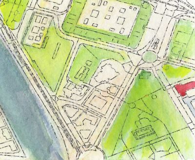
Woche 1 (von Montag, 1. Januar 2018 bis Sonntag, 7. Januar 2018) [Edit]

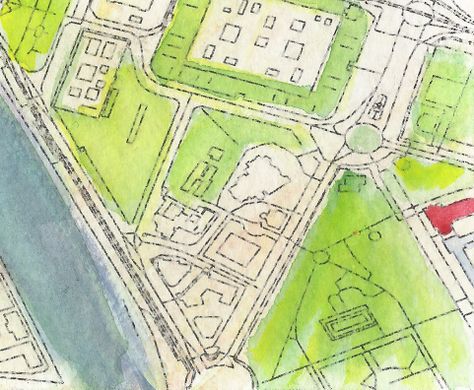
- English : Detail from a watercolour map of Seville, created by Andrew McGuire as a Christmas present for his wife. Hand-painted upon an OpenStreetMap base-map via Mapzen.
Woche 2 (von Montag, 8. Januar 2018 bis Sonntag, 14. Januar 2018) [Edit]

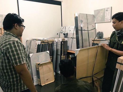
- English : As part of the InAWARE project by HOT in Indonesia, 500 framed OpenStreetMap maps were delivered to village offices around Jakarta, to help officials identify infrastructure in their area. Previously many such offices used rough hand-drawn maps.
- Deutsch : Im Rahmen des HOT-Projektes InAWARE wurden 500 gerahmte OpenStreetMap-Karten an Dorfverwaltungen im Umland von Jakarta verteilt, um bei den Verwaltungsangestellten Bewusstsein für die Infrastruktur in ihrem Umkreis zu schaffen. Bis dato verwendeten viele dieser Verwaltungsbüros lediglich grobe, handgezeichnete Karten.
Woche 3 (von Montag, 15. Januar 2018 bis Sonntag, 21. Januar 2018) [Edit]

- English : Car parks take up a lot of space within our cities. What The Street visualises this and other uses of city space for cars, trains, and cycles using OpenStreetMap data.
- Deutsch : Autoparkplätze verschlingen viel Raum in unseren Städten. What The Street visualisiert dies und andere Arten der Raumnutzung in Städten durch Autos, Züge und Fahrräder auf der Datenbasis von OpenStreetMap.
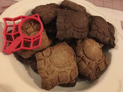
Woche 4 (von Montag, 22. Januar 2018 bis Sonntag, 28. Januar 2018) [Edit]
- English : Christian Quest's latest creation is a 3D printed OpenStreetMap logo shaped cookie-cutter!
Woche 5 (von Montag, 29. Januar 2018 bis Sonntag, 4. Februar 2018) [Edit]

- English : No image was featured this week.
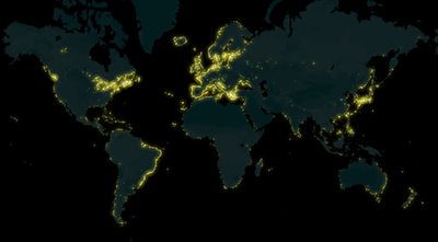
Woche 6 (von Montag, 5. Februar 2018 bis Sonntag, 11. Februar 2018) [Edit]

- English : A map of lighthouses all over the world mapped on OpenStreetMap, made by Arun Ganesh (planemad). See also the interactive map on MapBox.
Woche 7 (von Montag, 12. Februar 2018 bis Sonntag, 18. Februar 2018) [Edit]

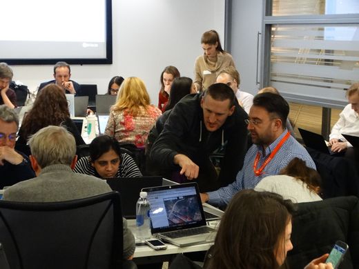
- English : Sharing OpenStreetMap editing techniques at the regular Missing Maps Project event in London.
Woche 8 (von Montag, 19. Februar 2018 bis Sonntag, 25. Februar 2018) [Edit]

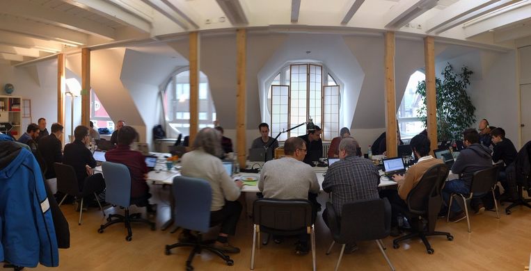
- English : Working on OpenStreetMap tech at the Karlsruhe Hack Weekend.
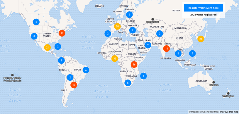
Woche 9 (von Montag, 26. Februar 2018 bis Sonntag, 4. März 2018) [Edit]

- English : This year Open Data Day will be celebrated on March 3rd and there are already 406 events registered all around the world. Many of them will have activities related to OpenStreetMap.
 Check out the map and participate in an event near you!
Woche 10 (von Montag, 5. März 2018 bis Sonntag, 11. März 2018) [Edit]

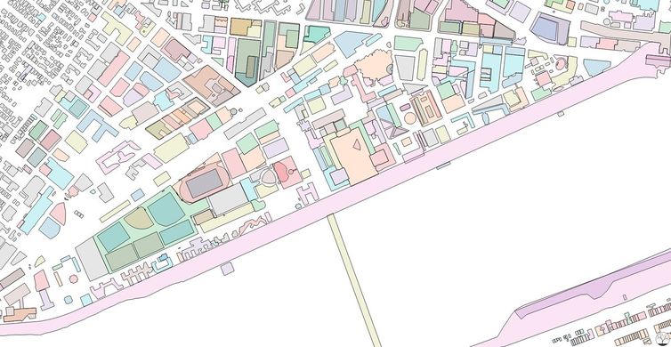
- English : Colorful exploration of OpenStreetMap buildings data on the MIT Campus in Cambridge, Massachusetts, United States. Map produced by Curran Kelleher [1].
- Deutsch : Farbenfrohe Darstellung von Gebäudedaten aus OpenStreetMap auf dem MIT Campus in Cambridge, Massachusetts, USA. Die Karte wurde erstellt von Curran Kelleher [2].
Woche 11 (von Montag, 12. März 2018 bis Sonntag, 18. März 2018) [Edit]

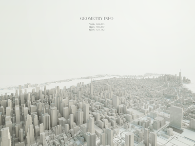
- English : Beautiful 3D visualization of Manhattan's OpenStreetMap data. Made by Matteo Prati using the open source software Blender. Check out other images in his website.
- Deutsch : Sehr schöne 3D Visualisierung der OpenStreetMap Daten von Manhattan, die von Matteo Prati mit der Open Source Software Blender erstellt wurde. Weitere Bilder findet man auf seiner Webseite.
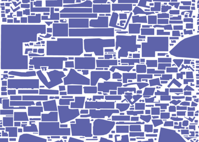
Woche 12 (von Montag, 19. März 2018 bis Sonntag, 25. März 2018) [Edit]

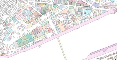
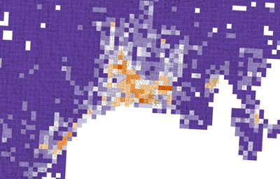
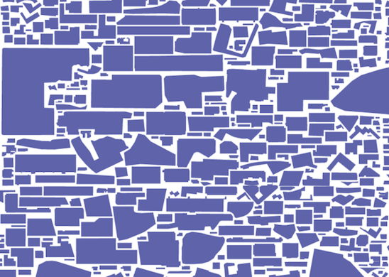
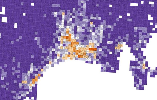
- English : Diversity of OpenStreetMap retail and services in Nice, Alpes-Maritimes, Provence-Alpes-Côte d'Azur, France. Orange tiles indicate a high diversity, while purple tiles indicate a low diversity. Image produced by Alessandro Venerandi.
- Deutsch : Vielfalt von Einzelhandels- und Dienstleistungsbetrieben in OpenStreetMap in Nice, Alpes-Maritimes, Provence-Alpes-Côte d'Azur, France. Orange Kacheln weisen eine hohe Vielfalt auf während violette Kacheln auf eine geringe Vielfalt hinweisen. Das Bild wurde erstellt von Alessandro Venerandi.
Woche 13 (von Montag, 26. März 2018 bis Sonntag, 1. April 2018) [Edit]

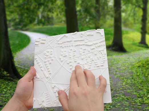
- English : Touch Mapper (touch-mapper.org) lets you create a 3D printed maps based on OpenStreetMap data. Tactile maps like this can be used for navigation by the blind.
- Deutsch : Touch Mapper (touch-mapper.org) ermöglicht es physische 3D Karten basierend auf OpenStreetMap-Daten herzustellen. Taktile Karten wie diese können beispielsweise von blinden oder sehbehinderten Menschen zur Navigation verwendet werden.