FR:Maxheight Map

Introduction
Identifier les oublis maxheight=* de tags sur (railway) pont.
Absence maxheight Tags
- maxheight tags sur les ways
- maxheight tags sur les noeuds (à proximité d'une point d'intersection), tag sur un noeud is propagated à un way dans le cas d'un tunnel /
covered=*
Calques
Note: L'absence du tag maxheight est analysé dans la limite de l'utilisation des valeurs de highway : primary, secondary, tertiary, trunk, service, residential, primary_link, secondary_link, tertiary_link, trunk_link et unclassified.
| Nom du calque | Tag present sur les ways | Tag absent | Exclusion des ways tagués | Detail de description |
|---|---|---|---|---|
| Passage couvert | covered=*
|
maxheight=* ou maxheight:physical=*
|
Affichage de tous les highway tagué d'un covered=yes et sans tag maxheight. | |
| tunnel | tunnel=yes, tunnel=building_passage
|
man_made=adit
|
Affichage de tous les highway tagué d'un tunnel=yes ou building_passage et sans tag maxheight. Les highway tagué d'un man_made=adit sont ignorés | |
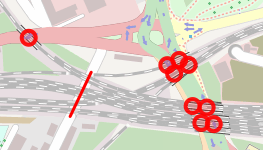
| way en dessous d'un pont en railway | railway=*, bridge=yes, bridge=viaduct
|
tunnel=*
|
Début avec les ways tagués d'un railway=* et bridge=yes ou bridge=viaduct ayant l'information d'une intersection highways sans tag maxheight ou maxheight:physical d'ajouté. Les tunnels sont exclus. | |
| way en dessous d'un pont bridge | bridge=yes, bridge=viaduct
|
tunnel=*, railway=*
|
Début avec les ways tagué d'un bridge=yes ou bridge=viaduct (Exclusion des railway=*), ayant l'information d'intersection des highways sans les tag maxheight ou maxheight:physical sont affichés. Les tunnels sont exclus. |
Styles
| Layer | Comment | Couleur | Example |
|---|---|---|---|
| layer=0 | Valeur par défaut, ou non tagué pour |
|
 (50.33498, 7.58883) |
| layer=1 | Valeur par défaut pour bridge=yes, bridge=viaduct |
| |
| layer=2 |
| ||
| layer=3 |
| ||
| layer=<autre> |
|
Test des valeurs existantes (Overlays)

| Nom de calque | OSM Tags | Color Keys | ||||||||||||||||||||||||||||||||||||||||||
|---|---|---|---|---|---|---|---|---|---|---|---|---|---|---|---|---|---|---|---|---|---|---|---|---|---|---|---|---|---|---|---|---|---|---|---|---|---|---|---|---|---|---|---|---|
| Hauteur maximum | maxheight=*
|
The default value of 4m can be adjusted in Simulation mode. Multiple values separated by a semicolon are evaluated on a one-by-one basis, the highest value wins. maxheight values may be specified in inch/feet or metric values. In case the node/way was only tagged with maxheight:physical, this tag will be evaluated instead with the same color key as shown above. | ||||||||||||||||||||||||||||||||||||||||||
| Maximum width | maxwidth=*
|
If used, ways will be marked red. Please suggest a suitable schema on the discussion page. | ||||||||||||||||||||||||||||||||||||||||||
| maximum length | maxlength=*
|
If used, ways will be marked red. Please suggest a suitable schema on the discussion page. | ||||||||||||||||||||||||||||||||||||||||||
| maximum weight | maxweight=*
|
The default value of 7.5t can be adjusted in Simulation mode. | ||||||||||||||||||||||||||||||||||||||||||
| maximum axleload | maxaxleload=*
|
If used, ways will be marked red. Please suggest a suitable schema on the discussion page. | ||||||||||||||||||||||||||||||||||||||||||
| maxspeed for hgv | maxspeed:hgv=*
|
Colors inspired by Maxspeed Karte. | ||||||||||||||||||||||||||||||||||||||||||
| hgv=* & hazmat=* | hgv=*, hazmat=*
|
Colors inspired by ITO Map - hgv routing layer. | ||||||||||||||||||||||||||||||||||||||||||
| toll | toll=*, toll:N3=*, barrier=toll_booth
|
|
Barre glissante
La Sidebar sur la gauche de la carte est fermée par défaut. Utilisez les icones ![]() etd
etd ![]() pour ovrir/fermer le panneauou cliquez sur la partie grise pour ouvrir la partie glissante.
pour ovrir/fermer le panneauou cliquez sur la partie grise pour ouvrir la partie glissante.
Here's a brief overview of the features you can find in the Sidebar:
Recherche
L'outil de recherche est fourni par Nominatim, indiquez votre lieu et tapez enter pour lancer la recherche.
Infos
Créer par
Attribution
- jquery ui + layout based design used with permission of misterboo (on OSM)

- Search provided by Nominatim
- Data provided by Overpass API

Options
Opacity
Intersection style
-
 Point style
 -
 Line Style


Simulation
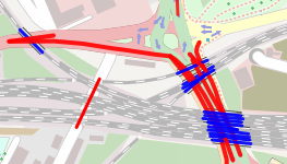
Vehicle Height: Simulate range from 1.00 - 5.00 m -> color blue / red
Weight: Simulate range from 1.0 - 30.0 t
GPS Position
Locate me: Uses your browser's Geolocation API to zoom to your area. Depending on GPS/Wifi availability the results may be more or less accurate.
Track my position: Automatically update your current location every 10 seconds.
GPX Export

- Zommer sur la zone d’intérêt de la carte
- Sélectionner un des calques missing maxheight tag
- Être sûr de la sélection Intersection style Point dans la Slidebar
- Exporter tous les points affichés sur la carte courante dans un GPX pour facilement planifier un routage dans Basecamp/QLandkarteGT ou pour vérifier les oublis de tag maxheight lors d'un trajet (offline usage)
- Les points sont exportés par des Waypoints avec "MH ..." en préfixe
- Note: Ce fonctionnement est supporté seulement avec Chrome et Firefox. Pour d'obscures raisons Firefox crée un fichier .part dans votre dossier de téléchargement. Il faut alors le renommer manuellement en .gpx.
Keyboard Shortcuts
| Keys | Action |
|---|---|
| Ctrl - Cursor Up | Open/Close North panel |
| Ctrl - Cursor Left | Open/Close West panel |
| Ctrl - Cursor Right | Open/Close East panel |
Technical details
Data provided by Overpass API (Version 0.7.2).
Supported browsers
- Desktop
- Firefox
- Internet Explorer 8, 9
- Google Chrome
- Opera
- Mobile
- Android Browser
- Chrome
- Firefox
- Opera mobile does not really work due to an OpenLayers/SVG bug (Vector graphics appear in the wrong place)
URL parameters
| Parameter | Description |
|---|---|
| lat, lon, zoom, layers | Latitude, Longitude, Zoom, Activated Layers (usual OpenLayers syntax applies) |
| label | Show labels. Parameter values include F (false) or T (true) |
| style | Show intersections as line or point |
| opacity | Set background opacity. Permitted values include 0 .. 100 (0 = map white) |
| timeout | Override default timeout of 10 seconds for some layers. Maximum value is 300 (seconds) |
| lang | Override automatically detected language. Example: &lang=en for English texts |