FR:Tag:waterway=tidal_channel
 |
| Description |
|---|
| Cours d'eau naturel dont la direction du courant change avec les marées |
| Groupe: cours d'eau |
| Utilisé pour ces éléments |
| Implique |
|
| Combinaisons utiles |
| Voir aussi |
| Statut : Approuvé |
| Outils pour cet attribut |
|
| Attention, cette page est une copie temporaire de la version anglaise, elle est en cours de traduction. |
Le terme tidal_channel désigne les fleuves à marées aussi connus sous le nom de rivières à marées ou rivières tidales.
On utilise les attributs waterway=tidal_channel pour un cours d'eau naturel proche de la côte ayant un sens du courant changeant en fonction des marées. De tels cours d'eau sont souvent dans des zones humides de type vasières, marais côtiers ou mangroves.
Ces cours d'eau se distinguent des rivières du fait de leur grande salinité et des vitesses de l'eau qui sont très proches de celles de la marée montante et de la marée descendante.
Différences entre les fleuves à marées et les estuaires
On trouve fréquemment les fleuves à marées le long des côtes. Leurs rives sont généralement en pente douce et isolent à marées basses les zones humides côtières (vasières, marais côtiers et mangroves) de l'action des vagues. Le fleuve à marée principal (celui qui arrive dans la mer) peut parfois être rejoint par de nombreuses rivières à marées (affluents) formant un vaste réseau au sein de ces zones humides. Mais ce ne sont pas des "river" ou "stream" au sens de OpenStreetMap car ces cours d'eau sont très salés lors des marées hautes et la marée influence directement le sens du courant sur toute la profondeur d'eau.
Some tidal channels connect to an estuary of a river and may be less salty than the sea, since the connect to the estuary. But in contrast to a river estuary, in a tidal channel the water flowing towards the sea at low tide is often slightly higher in salinity than the open sea water, due to evaporation, especially in mangroves and subtropical salt marshes. Unlike in a river estuary, the flow of water towards the sea at low tide is not significantly greater than the flow away from the sea at high tide in a tidal channel. By following the channel away from the sea, or observing the flow of water at low tide and high tide, it is apparent if the waterway is the estuary of a river, or a tidal channel.
Many tidal channels are currently mistagged as waterway=river, waterway=stream, natural=bay, or natural=water areas, and could be updated to this tag.
How to Map
- To map a tidal channel, make a simple linear
 way and add the waterway=tidal_channel tag to it. The direction of the way should be towards the sea (i.e. the direction of water flow at low tide).
- The centerline of a tidal channel should be outside of the coastline (natural=coastline), because this is a marine water body, below the high tide line.
- In mangroves, the natural=coastline is often drawn at the border of the open water at the ends of the tidal channel, but sometimes is drawn farther inland. In either case, the end of the mangroves should be drawn up to the edge of the open water in the tidal channel.
- In salt marshes and tidal mud flats, the borders of the tidal channel will still be outside of the coastline, but may be drawn as the outer limit of the natural=wetland
- In tidal flats, tidal channels may only be visible at low tide. In these cases the tag should generally be reserved for named tidal channels, or those that are significant for navigation.
Additional tags
- name=* to specify the name of the tidal channel, for example 'Big Creek'.
- width=* to indicate the width of the channel in meters. This is an approximate average width of the channel throughout most of the length of that part of the waterway.
- salt=yes/no to indicate whether the water is salty.
- intermittent=yes to indicate the waterway is dry at low tide
Examples
1) Tidal channels in tidal mud flats, in Germany

- name = Kronenloch
- waterway=tidal_channel
- name = Wöhrdener Loch
- waterway=tidal_channel
- The edges of the tidal channel are mapped as the end of the wetland=tidalflat
2) Tidal channel in mud flats, in Scotland

- OSM Way 694300595
- name = Barbara Channel
- waterway=tidal_channel
3) Tidal creek in salt marshes, in England:
- OSM Way 121698431
- name = Cabbage Creek
- Note that the edge of the open water is mapped as the border of the wetland=saltmarsh
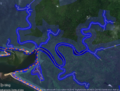
4) Tidal channel in mangroves, in Indonesia
- OSM Way 694868357
- waterway=tidal_channel
- The wetland=mangrove ends at the edges of the tidal channel, which is also set as the coastline
Similar features
- For an artificial (man-made) small watercourse, see waterway=ditch and waterway=drain.
- For a wider man-made watercourse created for navigation use waterway=canal.
- If the waterway is a natural estuary with lower salinity than the sea and a significantly greater flow of water toward the sea than away, use waterway=river
See also
Gallery
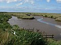
Small tidal channel in a salt marsh
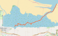
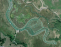
Cabbage Creek (orange line)
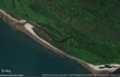
Tidal channel in mangroves
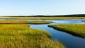
Tidal channels in a salt marsh
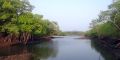
Tidal creek in mangroves
Hookton Slough, a channel in salt marshes
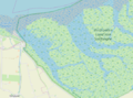
Channels in salt marsh, the Netherlands
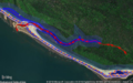
Mapping a tidal channel (red line with arrows) in mangroves with JOSM
Large branching tidal channels in mangroves in JOSM


