Featured images/Jul-Sep 2018
Jump to navigation
Jump to search


These are featured images, which have been identified as the best examples of OpenStreetMap mapping, or as useful illustrations of the OpenStreetMap project.
If you know another image of similar quality, you can nominate it on Featured image proposals.
| ← from July to September 2017 | ← from April to June 2018 | from October to December 2018 → | from July to September 2019 → |
Gallery of featured images, from July to September 2018
-
 2018, week 27
 -
 2018, week 28
 -
2018, week 29
-
 2018, week 30
 -
 2018, week 31
 -
2018, week 32
-
 2018, week 33
 -
2018, week 34
-
 2018, week 35
 -
 2018, week 36
 -
 2018, week 37
 -
 2018, week 38
 -
 2018, week 39
Details and captions
Week 27 (from Monday 2 July 2018 to Sunday 8 July 2018) [Edit]
- English : 3D rendering of Amsterdam by Paleo Pixels, who developed converter scripts to load OpenStreetMap data into the “Houdini” 3D software.
Week 28 (from Monday 9 July 2018 to Sunday 15 July 2018) [Edit]

- English : The Wikimedia Foundation recently announced new support for internationalized map renderings. E.g. showing European place names in Japanese.
Week 29 (from Monday 16 July 2018 to Sunday 22 July 2018) [Edit]

- English : Arjan Schrauwen from Dutch graphics design firm Beeldkompaan has taken a chunk of New York OpenStreetMap buildings data to a new moonbase location.
Week 30 (from Monday 23 July 2018 to Sunday 29 July 2018) [Edit]

- English : Little Big City, “Generating city on a little planet on the web”: a project by Yi Shen, using OpenStreetMap data via Nextzen vector tiles.
Week 31 (from Monday 30 July 2018 to Sunday 5 August 2018) [Edit]

- English : State of the Map 2018, the international OpenStreetMap conference, was held in Milan, Italy.
Week 32 (from Monday 6 August 2018 to Sunday 12 August 2018) [Edit]

- English : Miriam Gonzales and Céline Jacquin, from the Mexican OpenStreetMap community, were interviewed by the TV UNAM (the TV channel of the main Mexico university). They talked about OSM, GeoChicas and humanitarian mapping.
Week 33 (from Monday 13 August 2018 to Sunday 19 August 2018) [Edit]

- English : "Accumulation curves" showing the growth of shops data in the UK by SK53. This image shows a graph for each of the top shop types while his recent blog post compares and analyses growth shapes in various other ways.
Week 34 (from Monday 20 August 2018 to Sunday 26 August 2018) [Edit]

- English : Celebrations of the OpenStreetMap 14th Birthday, and a mapathon taking place in Dhaka, Bangladesh.
Week 35 (from Monday 27 August 2018 to Sunday 2 September 2018) [Edit]

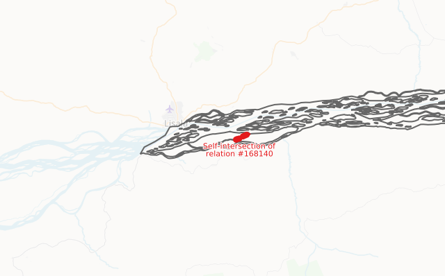
- English : OSM Inspector lets you find broken multipolygons now that the default map layer is less tolerant of rendering them.
Week 36 (from Monday 3 September 2018 to Sunday 9 September 2018) [Edit]

- English : A visualisation of the increase in the node density in the Philippines from April to the end of June 2018
Week 37 (from Monday 10 September 2018 to Sunday 16 September 2018) [Edit]

- English : The OSM-for-the-dyslexic project (osm4dys.org) is creating apps and map styles for use by dyslexic people.
Week 38 (from Monday 17 September 2018 to Sunday 23 September 2018) [Edit]

- English : Public health researcher John F. Pearson created this map for a Public Health Post article, showing open data on discarded needle collections in Boston, Massachusetts, presented on an OpenStreetMap base map.
Week 39 (from Monday 24 September 2018 to Sunday 30 September 2018) [Edit]

- English : The community engaged in disaster preparedness/response mapping for Typhoon Ompong in the Philippines, including this mapathon event hosted by the Red Cross.