JA:Proposed features/lifts
| Elevators/Lifts | |
|---|---|
| Proposal status: | Abandoned (inactive) |
| Proposed by: | Lulu-Ann |
| Tagging: | highway=elevator
|
| Applies to: | |
| Definition: | A vertical public right-of-way for pedestrians |
| Statistics: |
|
| Rendered as: | |
| Draft started: | 2008-01 |
| RFC start: | 2009-04-24 |
| Vote start: | * |
| Vote end: | * |
説明
公共のエレベーター elevator (またはリフト)は、垂直的に移動し、人や荷物を別の階へ届けるのに使われます。
例: ロンドンの Golden Jubilee Bridges は、両端にリフトがあり、通常経路の階段を使えない別手段として車いすでの利用を可能にしています。
もっと多くの公共エレベーターの例は、こちら here をご覧下さい。
屋外公共エレベーターのマッピング
推奨されるマッピング方法: Add a node ![]() at the location of the elevator and add
at the location of the elevator and add highway=elevator (c.f. highway=steps, which is also a physical description rather than a legal right-of-way type). For larger elevators, such as freight lifts, draw an enclosed way ![]() around the outline of the lift. For non-vertical incline elevators, draw a straight way
around the outline of the lift. For non-vertical incline elevators, draw a straight way ![]() along the elevator's path.
along the elevator's path.
Connect highway=elevator with highway=footway or any other appropriate tag.
注意: Incline elevators should not be confused with longer-distance trams or aerial incline cable cars; continue to use railway=tram and aerialway=cable_car respectively.

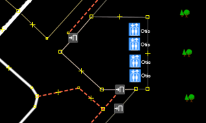
highway=elevator タグはJOSM中のビル内に配置され、brand=Otis というラベルが付けられています。屋内公共エレベーターのマッピング
屋内にあるエレベーターは、もし、詳細なエレベーター位置がわかってないなら、elevator=yes でもってbuilding=*と同様のプロパティでタグ付けできます。もし、詳細な位置がわかっているならば、エレベーターまたは複数台エレベーターをhighway=elevatorタグを用いて独立したノードとして追加するのが、好ましい方法でしょう(preferred level of detail to work towards)。フロアの数は、building:levels=*を用いて building=*タグで指定します。
エレベーターの欠如
もし、エレベーターがないならば、車いす利用者にとって建物へのアクセスしやすさに関しては否定的な影響となるでしょう(建物が1階よりもっとあったなら)。
エレベーターの欠如はbuilding=* またはロケーションノードで elevator=no とタグ付けすることによって示すことができます。

利用制限
大部分は歩行者で、もちろん車いすもです。ひょっとすると、自転車も可能かもしれません。wheelchair=designated, foot=yes は初期値として了解されるでしょう。適切なaccess=*と組み合わせてください。
レンダリング
エレベーター/リフトのアイコンは ![]() JOSMの様なメジャーなマップエディタで使われるでしょう。このアイコンはまた、slippy mapでのズームレベル18においてレンダリングすることが可能です。
大きなエレベーターは、
JOSMの様なメジャーなマップエディタで使われるでしょう。このアイコンはまた、slippy mapでのズームレベル18においてレンダリングすることが可能です。
大きなエレベーターは、highway=footway, area=yesと同様の薄い灰色のエリアとアイコンが組み合わさった形でレンダリングされ、エリア![]() としてマップされます。
傾斜したエレベーターは
としてマップされます。
傾斜したエレベーターはrailway=* タグと同様の灰色のウェイと一つのアイコンを持ちます。
[ dead link ]
[ dead link ]
タグ付け例 & 説明
| Example | Suggested Tagging |
|---|---|
| A Schindler-manufactured public elevator inside of a downtown office tower with Braille dots. |
|
| An employee elevator located somewhere inside of a supermarket. Specific location unknown. |
|
| A large non-public Otis freight elevator inside of a shopping mall. Location known. | |
| An outdoor Dover elevator with Braille. Elevator has English speech output. Location known. Bicycles ok. |
|
| An guest-only Schindler elevator inside of a hotel resort with Braille. Guest shows key to guard to access. |
|