Potlatch
| Potlatch | ||||||||||||||||||||||||||||||||||||||||||||||||||||||||||||||||||||||||||||||
|---|---|---|---|---|---|---|---|---|---|---|---|---|---|---|---|---|---|---|---|---|---|---|---|---|---|---|---|---|---|---|---|---|---|---|---|---|---|---|---|---|---|---|---|---|---|---|---|---|---|---|---|---|---|---|---|---|---|---|---|---|---|---|---|---|---|---|---|---|---|---|---|---|---|---|---|---|---|---|
| Author: | Richard Fairhurst and contributors GitHub | |||||||||||||||||||||||||||||||||||||||||||||||||||||||||||||||||||||||||||||
| License: | WTFPL | |||||||||||||||||||||||||||||||||||||||||||||||||||||||||||||||||||||||||||||
| Platforms: | macOS and Windows | |||||||||||||||||||||||||||||||||||||||||||||||||||||||||||||||||||||||||||||
| Status: | Active | |||||||||||||||||||||||||||||||||||||||||||||||||||||||||||||||||||||||||||||
| Version: | 3.1 releases (2024-06-12) | |||||||||||||||||||||||||||||||||||||||||||||||||||||||||||||||||||||||||||||
| Language: | English
| |||||||||||||||||||||||||||||||||||||||||||||||||||||||||||||||||||||||||||||
| Website: | https://www.systemed.net/potlatch | |||||||||||||||||||||||||||||||||||||||||||||||||||||||||||||||||||||||||||||
| Source code: | systemed/potlatch3 GitHub | |||||||||||||||||||||||||||||||||||||||||||||||||||||||||||||||||||||||||||||
| Programming language: | ActionScript | |||||||||||||||||||||||||||||||||||||||||||||||||||||||||||||||||||||||||||||
|
OpenStreetMap intermediate-level editing software for desktop | ||||||||||||||||||||||||||||||||||||||||||||||||||||||||||||||||||||||||||||||
| ||||||||||||||||||||||||||||||||||||||||||||||||||||||||||||||||||||||||||||||
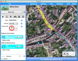
Potlatch is an OpenStreetMap editor for Mac and Windows desktop.
The current version is 3.1 which runs as a desktop application.[1] Previous versions (2.x, 1.x) ran as in-browser editors on openstreetmap.org using Adobe Flash Player.
You can download the latest version at https://www.systemed.net/potlatch.
Potlatch's distinguishing characteristic is that it's extraordinarily ergonomic for moderately familiar users, without ever having too complex an interface. With a handful of keyboard shortcuts you can zip about the map and perform common editing actions efficiently: for example, you can skip 10 nodes back/forward along a way with one keypress, jump to the other end of the way with another, then assign a set of multiple tags to the way (which you've previously recorded) with another single keypress[2].
As yet, Potlatch does not run reliably on Linux systems due to Adobe AIR for Linux being discontinued. However, it will reportedly run under Wine.[3]
Development of 3.0 was supported financially by the OpenStreetMap Foundation.[4]
The latest version 3.1 adds OAuth 2 support which is required to edit OpenStreetMap since June 1st, 2024[5].
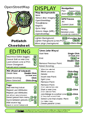
Keyboard shortcuts
| These shortcuts are for Potlatch 1 and may have changed in Potlatch 3. This section of the article may need additional editing. |

At present, shortcuts may vary or be non-functional for non-UK/US keyboards.
Moving around the map
- Cursor keys to move one step at a time.
- Page Up and Page Down to zoom in/out.
Editing
- Click on a blank area to start a new line.
- Double-click on a blank area to insert a new point of interest.
- Esc to cancel an edit or a new line.
- Z to undo.
- When drawing a line:
- ↵ Enter to stop drawing a line.
- ⌦ Del to remove the previous point.
- When a way is selected:
- ⇧ Shift+Click on this way to insert a new point.
- Control+Click on another way to merge them, if they share an end-point. (Command/Apple key on a Mac.)
- ⇧ Shift+Click on the relation button to add the way to the last used relation.
- ⌦ Del to delete an entire way.
- P to create parallel ways.
- T to straighten a way - especially useful in grid systems. If used on a closed way, makes it into a smooth circle.
- When a point is selected:
- Click an end-point to extend the way.
- X to split a way.
- ⌦ Del to delete a point.
- - to remove a point from the current way only.
- ⇧ Shift+Click to start a new way from this point.
- / to select another way which shares this point (useful for ways 'hidden' under other ways).
- Note: If using an internationalized keyboard, you might need to use the '/ or ÷ at the numeric keyboard. (And if you use a laptop you will perhaps need to press Fn-/ or Fn-÷ , usually printed in some color.)
- K to lock or unlock a way/POI.
- S to save your changes and add a commit message (if editing with save).
- C to close the changeset (and add a commit message if editing live).
Map display
- Function keys to select background:
- F1 to turn background off.
- F2 for Yahoo! Aerial Imagery.
- F3 for OSM Mapnik layer
- F4 for OSM Osmarender layer
- F5 for OSM Maplint (errors) layer
- F6 for Cycle map
- F7 for out-of-copyright map
- Hold ⇧ Shift to make it lighter.
- g to load GPS data for current area.
- ⇧ Shift+G to load GPS data from current user only for current area.
- Hold Space while dragging to move the background imagery only (if it's misaligned).
- L to show the latitude and longitude of the current mouse position.
- ⇪ Caps Lock or D to make ways and POIs a light, translucent colour (useful for seeing the background).
- M to minimise/maximise the editor (fill the entire browser window).
Tags/attributes
- + or = to add new key/value.
- r to repeat last attributes.
- ⇧ Shift+R to repeat last attributes but ignore name/ref.
- 1 – 9 to select a preset from the menu.
- § or ' or ` to cycle between preset menus.
- B to add a source tag based on the current background.
- N to go straight to the name tag (adding one if it's not there already).
Tags/attributes memory
- Ctrl+Alt+1 – Ctrl+Alt+9 add preset tags to memory 1-9
- Example: set
bridge=yesandlayer=1on a way and press Ctrl+Alt+1 to save it to memory 1 (via cookie)
- ⇧ Shift+1 – ⇧ Shift+9 use preset tags previously saved to memory 1-9
- Example: ⇧ Shift+1 to set tags from memory 1 on a selected way or node
History
- H to show history of the selected way, and revert to a previous version.
- U to show deleted ways, and optionally undelete them.
Initial development
Potlatch 3 is the successor of Potlatch 2. It uses a different technology stack, because the Adobe Flash was discontinued. The OpenStreetMap foundation financially supported the major redesign.[2][6][7] The first beta version was announced on 18 December 2020.[8] A full version was announced on 1 January 2021.[1]
The Potlatch 3 source code is open source and available from GitHub.
References
- ↑ 1.0 1.1 “Richard Fairhurst's announcement of release of Potlatch 3”. 1 January 2021.
- ↑ 2.0 2.1 “Potlatch Microgrants Proposal”.
- ↑ “[OSM-talk] Potlatch 3 for desktop”. 2 January 2021.
- ↑ “OSMF Board Circular Resolution 2020/Res38 'Funding of projects used in core infrastructure (Nominatim, osm2pgsql, Potlatch)'”. 17 August 2020.
- ↑ “OAuth 1.0a and HTTP Basic Auth shutdown on OpenStreetMap.org”. 17 April 2024.
- ↑ OSMF Board/Minutes/2020-07
- ↑ 2020-08-01: mail from Guillaume Rischard
- ↑ Diary entry from Richard Fairhurst, Potlatch 2 (& 3) main developer announcing P3 beta

