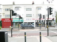
Tag:crossing=traffic_signals
Jump to navigation
Jump to search
| Description |
|---|
| Traffic light controlled pedestrian crossings |
| Group: Properties |
| Used on these elements |
| Requires |
| Useful combination |
| Status: approved |
| Tools for this tag |
|
This tag is used for traffic light controlled pedestrian crossings.
How to map
Set a node ![]() on the highway where the transition is or draw a way
on the highway where the transition is or draw a way ![]() and add highway=crossing + crossing=traffic_signals.
and add highway=crossing + crossing=traffic_signals.
Nearby can also be a traffic light (highway=traffic_signals) on another node.
Tags to use in combination
- traffic_signals:sound=yes/no
- traffic_signals:vibration=yes/no
- tactile_paving=yes/no
- wheelchair=*
- crossing:island=yes/no
- lit=yes/no
Do not use bicycle=no, because it blocks the road for bicycles.
Possible Mistagging
See also
- highway=traffic_signals - A traffic signal (or a set of those) for regulating circulation.
