Tag:highway=crossing
 |
| Description |
|---|
| The location of a street crossing for pedestrians, cyclists, or equestrians. |
| Group: crossings |
| Used on these elements |
| Useful combination |
| See also |
| Status: de facto |
| Tools for this tag |
This tag is for the location of a street crossing for pedestrians, cyclists, or equestrians. In American English, a pedestrian crossing is called a crosswalk if it is marked or signalized. See Crossings for other kinds of crossings.
This tag is only used on nodes. If a crossing is also represented by a way, tag the way with a different highway=* value corresponding to the kind of path that crosses the street, for example highway=footway footway=crossing for a pedestrian crossing.
How to map
To map a street crossing, place a node along the way representing the road, and add the highway=crossing tag to the node.
To describe the type of the transition in more detail, use:
crossing=*crossing=traffic_signals- regulated with light signalscrossing=uncontrolled(used by JOSM preset) - with markings, without traffic lightscrossing=marked(used by iD preset) - with markings, with or without traffic lightscrossing=unmarked- without markings or traffic lights
crossing:island=yes/no- to tag whether there is an island (former tagcrossing=islandcrossing:markings=*- to tag the existence and style of crossing markingscrossing:signals=*- to tag the existence of traffic signals controlling traffic at the crossingcrossing:lit=*- to tag if there is a designated light source for the crossing, which lights the crossing brightlycrossing:buffer_marking=*- to tag the existence and side of crossing buffer markingscrossing:kerb_extension=*- to tag the existence and side of crossing kerb extensionscrossing:continuous=*- to tag whether the path (footway, cycleway) continues visually uninterrupted across a roadtraffic_calming=table- Use this tag if the section of crossing is raised in comparison to the road it is crossing. Unfortunately, currently no tag is established to mark that it is not raised.
Access-Tags
bicycle=yes- is used to tag whether the crossing is also a cycleway crossing used by bicycles, note that this is better done through the (default) access rights of the crossing way.horse=yes- to tag whether the crossing is also a bridleway crossing used by horse riders, not needed if the crossing way is ahighway=bridleway.
Don't use foot/bicycle/horse=no if these traffic modes are allowed to cross the node in any direction (on the crossing or on the crossed way)! Notice that a crossing tagged with bicycle=no may be crossing a road where cycling is allowed[1]
See the Key:crossing page for additional documentation of this and many other available subtags.
Separately mapped footways
- Main article: Sidewalks#Sidewalk as separate way
In cases where sidewalks are mapped as separate ways it is necessary to also add a crossing way, from one sidewalk through the node shared with the road to the other sidewalk. footway=crossing and cycleway=crossing can be used on ways which lead from a sidewalk to the crossing node (the node which has this highway=crossing tag).
Such split can be also done when footway/cycleway is crossing the road (part where it is crossing may tagged with footway=crossing / cycleway=crossing).
Examples
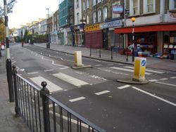
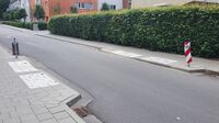
| Crossing unmarked | Crossing with traffic calming | Crossing near a stop | Crossing with island |
|---|---|---|---|
 |
 |
 |

|
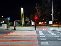
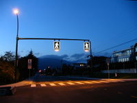
| Crossing with traffic signals | Crossing lit |
|---|---|

|

|
| Crossing & golf cart | Crossing & horse |
|---|---|

|

|
Rendering
- Shows up in OSM2World and in OSM France.
- OpenCycleMap:
 ,
, 
bicycle=yes - It also is displayed in the JOSM Editor
Routing
Used by OsmAnd, a routing software, to signal and alert.
See also
railway=crossing- Pedestrians can cross a railway hererailway=level_crossing- A crossing between a railway and a roadrailway=tram_crossing- A tram crosses the pedestrian way hererailway=tram_level_crossing- A tram crosses the road hererailway=railway_crossing- Crossing rails that do not interconnectrailway=switch- A railway switch- osm-yolo-crossings - AI import tool for zebra crossings
- Guidelines for pedestrian navigation
References
- ↑ See documentation of
bicycle=dismount, see discussions such as for example https://lists.openstreetmap.org/pipermail/tagging/2020-October/thread.html#55611 https://lists.openstreetmap.org/pipermail/tagging/2020-October/thread.html#55632 https://community.openstreetmap.org/t/routing-at-highway-crossing-with-foot-bicycle-horse-no/135081