Tag:landcover=greenery
| Description |
|---|
| An area covered in unspecified or various types of decorative greenery. |
| Group: natural |
| Used on these elements |
| See also |
| Status: in use |
| Tools for this tag |
|
For any area covered with greenery (a variety of plants, possibly including grass, herbs, shrubs (bushes), flowers, and small trees), regardless of it being on a roundabout, along a street or in a park/garden, etc.
This tag has been used for vegetation that is hard to classify, either because its kind or because its diversity. Unfortunately, this does not provide clear information about the kind of vegetation or the use of the land.
While the tag landuse=greenery has higher usage numbers this is almost entirely because of an import in Tilburg.
But consider using one of these more specific and more common tags instead, if possible:
Or look for other tags in use: ![]() landcover#values
landcover#values
- Keep in mind that
landcover=*describes the physical coverage of an area, not its function or usage.
Alternatives
natural=*
natural=shrubbery- An area coverd with maintained shrubs.natural=scrub- An area coverd with unmaintained shrubs.natural=wood- An area covered with trees.natural=heath- An area coverd with drawf shrubs (short bushes).natural=grassland- An area covered with grasses, sedges and mixed herbaceous (non-woody) plants
Linear features
natural=tree_row- A line of trees, often along a road or as a border between two areas.barrier=hedge- A line of closely-spaced shrubs or small trees which serves as a visual screen or physical barrier, or mark the boundary of an area.
Functional areas that might contain landcover=greenery
leisure=garden- A place where flowers and other plants are grown in a decorative and structured manner. Also used for small gardens (aka front or back yards).leisure=park- A park, usually urban (municipal) - recreational area often planted with areas of mown grass lawn, flowers, shrubs and trees.
Links
Gallery
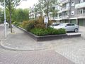
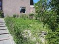
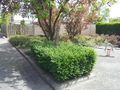
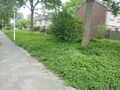
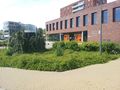
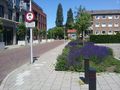
Some examples of areas tagged as greenery :
-
-
-
-
-
-
-
 Greenery in Beijing
 -
 Village greenery
 -
 Panoramio


.jpg)