Tag:man_made=monitoring_station
 |
| Description |
|---|
| A station that monitors something. |
| Group: man made |
| Used on these elements |
| Useful combination |
|
| Status: approved |
| Tools for this tag |
There is a large variety of monitoring stations. Examples of environmental monitoring stations include weather stations, stream gauges that check water levels in rivers, tide gauges that check sea level, noise monitoring, and air quality monitoring. Monitoring stations are also used to calibrate signals from global navigation satellite systems.
This tag doesn't refer to objects used to "monitor" - that means intercept, eavesdrop or wiretap - any communication infrastructure. See Proposed_features/Intelligence for these.
Tagging
Required
Monitored phenomena
Keys in the form monitoring:*=* are used to specify what properties or subjects are being monitored.
monitoring:*=yes– The given phenomena is actively monitored.monitoring:*=no– The given phenomena is not actively monitored. This tag is typically implied, but may be added to avoid ambiguity.
Browse taginfo to see all keys in use. Some common keys are:
Water
monitoring:water_level=*– Monitors surface water levels in rivers, streams, lakes, etc. (m)monitoring:tide_gauge=*– Monitors the tide level of the sea (m)monitoring:water_velocity=*– Monitors the speed of flowing water (m/s)monitoring:flow_rate=*– Monitors the volumetric flow rate of waterways like streams and rivers (m3/s)
monitoring:water_volume=*– Monitors the amount of water in a basin such as a reservoir (m3)
Groundwater
monitoring:groundwater=*– Monitors groundwater parametersmonitoring:groundwater_level=*– Monitors groundwater levels (m)
Water quality
monitoring:water_quality=*– Monitors one or more dimensions ofwater qualitymonitoring:water_temperature=*– Monitors the temperature of the sea, rivers, streams or lakes.monitoring:water_conductivity=*– Monitors the ability of water toconduct electricitymonitoring:water_turbidity=*– Monitors theturbidity of water, its claritymonitoring:water_pH=*– Monitors thepH of water, its aciditymonitoring:dissolved_oxygen=*– Monitors thedissolved oxygen of watermonitoring:salinity=*– Monitors thesalinity of water, its level of dissolved saltsmonitoring:water_nitrate=*– Monitors thenitrate content of watermonitoring:water_nitrite=*– Monitors thenitrite content of water
Weather
monitoring:weather=*– Monitors the weather.monitoring:wind=*– Monitors one or more dimensions ofwindmonitoring:wind_speed=*– Monitors the wind speed.monitoring:wind_direction=*– Monitors the wind direction.monitoring:precipitation=*– Monitors rain, snow, and other precipitation.monitoring:rainfall=*– Monitors only rainfall.
Air
monitoring:air_quality=*– Monitors one or more dimensions ofair qualitymonitoring:air_temperature=*monitoring:air_pressure=*monitoring:air_humidity=*monitoring:particulate_matter=*– Monitorsparticulates in the airmonitoring:visibility=*– Monitorsvisbility
Snow
monitoring:snow=*– Monitors one or more dimensions ofsnowmonitoring:snow_depth=*– Monitors the depth of fallen snow (m)monitoring:snow_density=*– Monitors the density of snowpack (kg/m3)
Soil
monitoring:soil_temperature=*– Monitorssoil temperaturemonitoring:soil_moisture=*– Monitorssoil moisture (sometimes called soil humidity)
Earth
monitoring:seismic_activity=*– Monitors seismic activity.
Space
monitoring:cosmic_ray=*monitoring:meteoric_activity=*– Monitors meteoric activity.
Radiation
monitoring:radiation=*– Monitors some kind ofradiation.monitoring:solar_radiation=*– Monitorssolar irradiance.monitoring:shortwave_radiation=*– Monitorsshortwave radiation.
Communications
monitoring:gps=*– Monitors signals from theGlobal Positioning System satellite cluster.monitoring:glonass=*– Monitors signals from theGLONASS satellite cluster.
Sound
monitoring:noise=*– Monitors ambient sound levels.
Traffic
monitoring:traffic=*– Monitors traffic.monitoring:bicycle=*– Monitors bicycle traffic, e.g. counting number of bicycle passing through a cycleway every day/week/monthmonitoring:pedestrian=*– Monitors pedestrian traffic, e.g. counting the number of people walking down a walkway or sidewalk
Structures
monitoring:air_gap=*– Monitors the open space beneath a structure, such as between a bridge and a river
Electronics
monitoring:battery_voltage=*– Monitors thevoltage of a battery, perhaps one that powers the monitoring station.
General
monitoring:temperature=*– Monitors some kind of temperature (probably air).monitoring:humidity=*– Monitors some kind of humidity (probably air).
Secondary
No defaults are defined here since depending on the type of station, the operator and the things monitored it is impossible to define an always correct default value.
display=yes/nodisplay:analog=yesdisplay:digital=yesrecording=yes/norecording:manually=yesrecording:automated=yesrecording:remote=yes
Useful combinations
operator=company name or similar- Сompany, corporation, person or any other entity who is directly in charge of the current operation of a map objectname=*- The primary name: in general, the most prominent signposted name or the most common name in the local language(s).ref=*- Used for reference numbers or codes. Common for roads, highway exits, routes, etcurl=*- Specifying an url related to a feature.website=*- Specifying the link to the official website for a feature.wikipedia=*- Provides a link to Wikipedia's article about the feature
Example images
-
 flood gauge at Murrumbidgee River.
 -
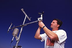 A technician examines a weather station's anemometer.
 -
 Remote GPS monitoring site.
 -
 Monitoring meteoric activity - FRIPON Network. (La Chapelle-aux-Lys - France)


External links
- International GPS Station Tracking Network -- GPS/GLONASS monitoring stations world wide
- MMS: Multi-Network Metadata System -- Weather stations world wide
- OGC Sensor Observation Service -- A protocol for reading data from sensors and creating sensor networks
See also
aeroway=windsock- An object that shows wind direction and speed.man_made=observatory- Area that can contain several monitoring stationsamenity=clock- A publicly visible clock- Proposed features/monitoring_station - approved proposal of this feature
- Proposed features/Street cabinet - proposal to unify several other types of technical cabinets commonly found in streets (may overlap with some monitoring stations)
- Mechanical edit proposal for converting measurement station to monitoring station
measurement=*- for measurements taken in from pipelines insubstation=measurement