Tag:archaeological_site=crannog
.jpg) |
| Description |
|---|
| A crannóg is a mostly or wholly artificial island used for habitation or as a workplace occurring in Ireland, Scotland and Wales. |
| Group: historic |
| Used on these elements |
| Useful combination |
| Status: in use |
| Tools for this tag |
|
A crannóg is a mostly or wholly artificial island/ islet in a water body or (less common) bog created for human habitation. Most of them were constructed circular in shape, others were oval. They were constructed from historic:civilization=prehistoric up to the historic:civilization=medieval period and inhabited as late as historic:period=victorian times.
In some cases, they a modern re-creation for educational purposes in heritage parks as part of a tourism=attraction.
Background
There are an estimated number of 2,000[1] crannógs in Ireland (110 are recorded in Co. Leitrim alone[2]), and there are 389 listed as monuments for Scotland[3]. Crannógs can vary in size from a diameter of c.10m to up to 40m[4] and were reached by their inhabitants by boat or causeway.
They can be found through local knowledge or historic maps (for example the British War office map for Ireland shows some of them with the label "Crannoge" or as circular islets with no label). Other resources to find them:
Some of the sites turn out not to be crannógs after all following archaeological excavations, so it is up to each mapper to make a judgement call to map it as an archaeological site or not depending on the available information.
How to spot on aerial imagery
Crannógs are usually between 10 and 40m in diameter, but on average around 25m[5] Compare between imageries, because the water level is highly dependent on the season, and some years are drier than others.
Sometimes, they are now on dry land due to changes in water level and could be mistaken as ringforts or similar land structures.
In a water body: Crannógs are either near the shore, formerly connected by a causeway (in rare cases still visible) or further into the lake. Lakes can have multiple crannógs in them. The crannóg will either appear as a vaguely circular islet with trees or shrubs growing on it; over the centuries, more deposits might have changed the islet into a less circular shape. The other case, when the water level has risen, is something vaguely circular underwater or algae forming in a circular way.
In a bog (might be a drained lake): Circular patch of different shade than the surrounding area, possibly a tree or a group of trees growing on it.
There is no guarantee that what you find will be an actual crannóg, but the following examples were all discovered on aerial imagery and confirmed by the National Monuments Service of the Republic of Ireland. It's better to report something that is nothing than to not report it, when you are in doubt.
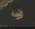
Crannóg at Southern shore of Mill Lough, Co. Cavan. Recognizable as a circular group of trees. https://www.openstreetmap.org/way/1105294164
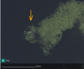
Crannóg in Parisee Lake. Recognizable as an almost circular with possibly some young trees (the white bits) growing from it. https://www.openstreetmap.org/way/1102716166
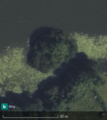
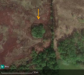
Crannóg at the Western shore of Kilconny Lough, Co. Cavan. Recognizable by shape, trees growing on it and lack of algae vegetation. https://www.openstreetmap.org/way/1106649745
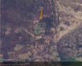
Same crannóg as before in Kilconny Lough, Co. Cavan, but on Esri Imagery. https://www.openstreetmap.org/way/1106649745
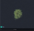
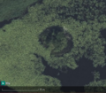
Crannóg in Laurel Lough, Co. Monaghan. Recognizable as circular vegetation (algae?). https://www.openstreetmap.org/way/1244643054
Crannóg in Cor Bog, Co. Monaghan, on Bing. Recognizable by its shape and different vegetation to its surroundings, i.e. tres. https://www.openstreetmap.org/way/1233083086
Crannóg in Cor Bog, Co. Monaghan, on Esri.


Tagging
Because both place=* and historic=* are main keys, the islet and the crannóg have to be mapped separately to have the crannóg displayed on OSM Carto as a historical site. See One_feature,_one_OSM_element.
Historic sites
See further down below for modern reconstructions, i.e. experimental archaeology sites.
Draw the area or set a node with the following tags:
| tag | explanation |
|---|---|
| historic=archaeological_site | Use only for genuinely "old" sites, i.e. not museum reconstructions, unless they have burnt down or been otherwise destroyed and have become the subject of archaeological research already[6]. |
| archaeological_site=crannog | Sub-classify site as crannóg. |
Map the place=islet, if still visible above water, as the/ an inner part of the water body relation.
| tag | explanation |
|---|---|
| historic:civilization=* | Depending on when they were built and/or occupied (if known). |
| historic:period=* | Depending on when they were built and/or occupied (if known). |
| heritage=* | If certified as heritage. Use additional references according the the country applicable, where available, ref:IE:smr=* for the Republic of Ireland and ref:canmore=* for Scotland. |
| access=* | These might be vulnerable sites, often on private land, so please indicate if they are accessible to the public or not. |
| wikimedia_commons=* | Many of the Scottish sites have photographic representation on WikiCommons. |
Experimental archaeology sites
| tag | explanation |
|---|---|
| archaeological_site=crannog | Classify site as crannóg. |
| place=islet | Usually the same area as the crannóg itself. |
| access=* | Depending whether they are part of a facility purely for research or accessible to the public. |
| tourism=attraction | If it applies. They usually have a website=*. |
| historic:civilization=modern |
Reconstructed crannógs usually have one or more huts with roof:material=thatch built on them.
Examples
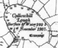
A crannog(e) in Co. Leitrim on the British War office map

Loughbrickland Crannóg in Northern Ireland (show on OSM)
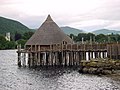
A reconstructed crannog near Kenmore, Perth and Kinross, on Loch Tay, Scotland (show on OSM). The roundhouse burnt down in 2021, unfortunately.

Crannog and wood-turning, Irish National Heritage Park, Co. Wexford, Ireland (show on OSM)

Reconstruction of a crannog in Craggaunowen, Co. Clare (show on OSM)


Further information
- Aidan O'Sullivan: Crannogs - Lake-dwellings of early Ireland, Dublin 2000. ISBN 1-86059-091-8 (48 pages)
- Ian Morrisson: Landscape with Lake Dwellings - The Crannogs of Scotland, 1986. ISBN 9780852244722 (128pp)
- Time Team Episode on a crannog in Scotland (see on OSM)
- Crannog on Wikipedia
- Crannogs in Irish folklore (duchas.ie)
- Prehistoric pile dwellings around the_Alps
Possible mapping mistakes
References
- ↑ Aidan O'Sullivan (UCD) discusses infrastructure archaeology and medieval settlement in Ireland
- ↑ https://maps.archaeology.ie/HistoricEnvironment/
- ↑ https://en.wikipedia.org/wiki/Crannog
- ↑ Aidan O'Sullivan: Crannogs - Lake-dwellings of early Ireland, 2000, p. 15
- ↑ I've found 16 so far; so I'm describing my experience in the Republic of Ireland here.
- ↑ Like the first Loch Tay crannog.