Talk:Tag:railway=subway entrance
Support the proposal. Not too cluttering
I believe this is specifically proposed as railway=subway_entrance ? I support this proposal. There has been comment that such things "clutter up the map". I'd respond that this is a rendering issue, not a data entry issue. If something is not tagged, nothing can be done with it and the data collection opportunity is lost. If something is tagged, a general renderer can simply ignore it, or only show it at detailed zoom levels. MikeCollinson 02:39, 19 February 2007 (UTC)
- This probably probably needs expanding to cover access to pedestrian routes that are not obvious from the maps. The main reason for NEEDING to include them is where pedestrians can cross busy roads but we probably need to come up with a standard tagging method that handles not only subway entrances, but any route where a pedestrian can gain access to overpasses, underpasses, and other pedestrian only areas which also have roads crossing them. I'm thinking of the likes of Prague where there are under ground shopping ares, that may also have a metro station at one end? Lester Caine 10:41, 19 February 2007 (UTC)
- I support this proposal. Should we be able to tag the Entrance with user categories 'foot=yes', 'bicycle=yes' and state that that the default is for 'foot=yes'? Also, the current model isn't really able to distinguish which side of a busy road an entrance is on which is something that will need to be sorted out separately. Peter Miller 9:23am 11 June 2007
- The access and default suggestions makes sense. Having an explicit default(s) for other existing tags would be good practise. MikeCollinson 10:38, 16 June 2007 (BST)
- Would not the location be obvious from where the tag was placed? I'm always careful to place things like bus stops, post boxes, shops on the correct side of a previously entered highway way. MikeCollinson 10:38, 16 June 2007 (BST)
- I agree with Ewmjc; unless the entrance is in the center of the road (which I would say is fairly unlikely), which side of the road should be obvious. --Hawke 20:40, 14 September 2007 (BST)
- Sorry to disappoint you, but that is fairly common in e.g. Berlin. Most of the old stations are build with one platform between two tracks and the entrance up into a traffic island in the middle of the street. Henry Loenwind 18:22, 17 May 2008 (UTC)
- I agree with Ewmjc; unless the entrance is in the center of the road (which I would say is fairly unlikely), which side of the road should be obvious. --Hawke 20:40, 14 September 2007 (BST)
- Would not the location be obvious from where the tag was placed? I'm always careful to place things like bus stops, post boxes, shops on the correct side of a previously entered highway way. MikeCollinson 10:38, 16 June 2007 (BST)
- The access and default suggestions makes sense. Having an explicit default(s) for other existing tags would be good practise. MikeCollinson 10:38, 16 June 2007 (BST)
- I support this proposal. Should we be able to tag the Entrance with user categories 'foot=yes', 'bicycle=yes' and state that that the default is for 'foot=yes'? Also, the current model isn't really able to distinguish which side of a busy road an entrance is on which is something that will need to be sorted out separately. Peter Miller 9:23am 11 June 2007
And, hey, would the original proposer like to open voting now? This will be a very useful addition to me if accepted! MikeCollinson 10:38, 16 June 2007 (BST)
- And what about subways that serve buses? Seattle's "subway" was an electric bus guideway (until just recently - it's currently being refitted to add light rail). --Cohort 22:06, 14 September 2007 (BST)
- And what about subways entrance accessibility? It could be useful to indicate which entrances of a station have lift for people with wheelchair. --Livewire74 11:44, 5 October 2007 (CST)
- FWIW, a proposed tag is here: Proposed_features/wheelchair. --Colin Marquardt 00:00, 8 October 2007 (BST)
- See also Proposed_features/lifts --Lulu-Ann 15:44, 5 March 2009 (UTC)
- FWIW, a proposed tag is here: Proposed_features/wheelchair. --Colin Marquardt 00:00, 8 October 2007 (BST)
- And what about subways entrance accessibility? It could be useful to indicate which entrances of a station have lift for people with wheelchair. --Livewire74 11:44, 5 October 2007 (CST)
Several railway lines going into a large railway station
Another related problem presents itself when you have several railway lines going into a large railway station. Baker Street is a good example. For rendering reasons I've just created one railway=station node, and positioned this in the best place, such that the circle line goes through in roughly the right place, and somebody looking at map will hopefully guess that the main station entrances (at street level actually, not particuarly subway) are onto Baker St and Marylebone Rd.
The station platforms are not necessarily at that one spot of course, which means there is some fiction involved in drawing the railway=rail ways through the railway=station node. Now Jubilee line and Bakerloo line are deep underground anyway, so it's difficult to know where exactly the platform is, and map users generally dont care anyway. The circle line is in roughly the right place (maybe slightly further south, since i think it runs under Marlyebone Rd actually)
BUT the metropolitan line platform is visible in Yahoo imagery, and is about 50-100 meters further north from the location of the railway=station node. This means the southward bend in the met line track, is ficticious. In fact the track continues parallel to Allsop place, and merges into the circle line to the East.
I figured I would map it like that for now. We don't really want two different Baker Street nodes (baring in mind that many/most map usage doesn't involve zooming in this much anway), so I just left a node with a note on the met line platform. Something to be fixed by coming up with some new node/relation tagging. On the other hand, trying to map the exact locations of platforms and connecting pedestrian tunnels, is maybe a slipperly slope to avoid.
-- Harry Wood 13:09, 8 November 2007 (UTC)
- How about we get rid of railway=station concept. Instead, tag nodes or areas as ticket halls, and have those appear on maps. In underground stations, I would expect these nodes or areas to be disconnected from railway=rail lines. We would then use relations to associate these with the lines and the nodes representing the position of the platform on the line. Some consideration would be needed for stations with several ticket halls (like Elephant and Castle). Possibly we would designate one of the ticket hall nodes as the primary one for use at mid-zooms. Morwen 13:56, 8 November 2007 (UTC)
- is there something real coming up with relations, and, if yes, where could i find more on that? --Osm6150856065 12:44, 16 April 2009 (UTC)
- How to tie the subway entrances to the actual subway stations? What avout highway=footway+tunnel=yes? Access tags according to the correct access restrictions of corse. --Skippern 00:38, 25 December 2009 (UTC)
Voting in 2007
Voting is opened as of September 14th 2007, last vote cast in 8 nov 2007: these people voted for approval: Ivansanchez Colin Marquardt Hawke Cohort Peter James Andrewpmk MikeCollinsonDido lets talk about it EsbenDamgaard Nevermind
- I approve "railway=subway_entrance". Ivansanchez 16:19, 14 September 2007 (BST)
- I approve "railway=subway_entrance". --Colin Marquardt 18:26, 14 September 2007 (BST)
- I approve "railway=subway_entrance". --Hawke 20:42, 14 September 2007 (BST)
- I approve "railway=subway_entrance". --Cohort 22:06, 14 September 2007 (BST)
- I approve "railway=subway_entrance". --Peter James 22:30, 14 September 2007 (BST)
- I approve "railway=subway_entrance". Andrewpmk 02:45, 15 September 2007 (BST)
- I approve "railway=subway_entrance". MikeCollinson 13:05, 15 September 2007 (BST)
- I approve "railway=subway_entrance". --Dido 20:48, 15 September 2007 (BST)
- I approve "railway=subway_entrance". --EdoM (lets talk about it) 08:20, 16 September 2007 (BST)
- I approve "railway=subway_entrance". EsbenDamgaard 11:18, 30 September 2007 (BST)
- I approve "railway=subway_entrance". --Nevermind 12:20, 8 November 2007 (UTC)
binding entrances to the station
IMO the most logical way is to draw the footways leading to the underground platforms. Anything less than that is just a temporary construct. Alv 10:00, 30 May 2010 (UTC)
Why not to an area?
Often subway entrance is a separate building. --Varnav 18:05, 1 February 2011 (UTC)
- Seems like a good idea, you have to thing what will happen to renders and if they expect a node Erik Johansson 11:04, 14 October 2011 (BST)
Binding - make the subway_entrance a node in the station
By making the subway entrance a node in the larger station, it is clear which station this entrance belongs to. You can then use the name to specify the name of the entrance - "D3" or "Pedder Street". For Example: http://osm.org/go/41dN@q35I-- . --Jharvey 02:56, 9 May 2011 (BST)
- Subway stations don't feel like buildings to me, they are not above ground. This is a hard question imho. I think 112427969
 112427969 is clearly wrongly tagged, but I like the effect. Erik Johansson 11:04, 14 October 2011 (BST)
Also underground pedestrian walkthrough?
There are two types of subway stations under roads:
- Those where entrances are on both sides of the road and the tracks are in the middle under the road, so you can not avoid crossing the street by walking underground
- Those where entrances are on both sides of the road and the platform is in the middle, so you can cross the street by going underground.
For estimating the safetiness of pedestrian routes, it is needed to know wether you can use the subway as an alternative crossing. Are there any proposals how to map the difference? Or do we have to map the footway underground? Lulu-Ann
- Yes map them as footways no need to complicate things Erik Johansson 11:04, 14 October 2011 (BST)
Icon ideas

Idea: A staircase emerging out of the ground. U like underground, whatever is there. The symbol should't represent the London tube/German U-Bahn. Best would be one representing all railways which are under the ground (or even up).
- Why the London tube/German U-Bahn ? We need an international symbol. In Paris, the metro symbol is a 'M' within a red circle. The icon on the international maps shall be neutral. Avoid latin characters and derivation from local pratices.
- You are funny. I guess "M" is a latin character, too. How about the front view of a train in a tunnel?Lulu-Ann
- Why the London tube/German U-Bahn ? We need an international symbol. In Paris, the metro symbol is a 'M' within a red circle. The icon on the international maps shall be neutral. Avoid latin characters and derivation from local pratices.
A mapnik icon ideas are being discussed here
Entrance name
Currently, most entrances are not named at all (30%), some are named with the name of the station, and a few with the exit name. I suggest to use the tag name=* for the exit name, not for the station name. The name of the station (or stations) may be retrieved from the stop_area relation. And if the exit name is not known, fallback to current usage and use the name=* for station name. IMO exit names can be very useful to pedestrian routers: it can tell the precise exit name to get out of the station.--Oligo 22:32, 17 June 2012 (BST)
Entrance ref
In some subway networks (Bangkok, Tokyo), exits have a short reference like "2", "B1". This allows for fast orientation for people exiting the station. We could store this information in tag ref=*? Some people already tagged it that way. But there are also subway references in this tag... IMO it is not the appropriate tag for that.--Oligo 22:32, 17 June 2012 (BST)
Observed tagging practices
Currently there is no clear tagging scheme for binding entrances to stations. The reason I rewrote the page is because this tag is currently in use but poorly documented (TagInfo finds 10,213 subway entrances on 2012-07-03). This convention is based on tagging practices observed in June 2012 in Bangkok BTS Sukhumvit Line![]() Bangkok BTS Sukhumvit Line, stations Shchyolkovskaya in Moscow
Bangkok BTS Sukhumvit Line, stations Shchyolkovskaya in Moscow![]() Shchyolkovskaya in Moscow, Gänsemarkt in Hamburg
Shchyolkovskaya in Moscow, Gänsemarkt in Hamburg![]() Gänsemarkt in Hamburg and database surveys.
Gänsemarkt in Hamburg and database surveys.
Which role to set in relation public_transport=stop_area? From the ~28,000 stop_area relations (2012-06-06) having entrances, 773 entrances don’t have role, 427 have role="entrance", 107 have role="subway entrance" and 91 have role="subway_entrance".
I suggest to use no role at all, because the information that the node is an entrance is already present in the node itself. Or we could go with the most widespread use: "entrance". IMHO the "no role" or "entrance" propositions are better because they are not subway-specific, they can be used on other station entrances: airports, ferry terminals. --Oligo 21:16, 3 July 2012 (BST)
Entrances do not belong into stop_areas. Please read the Public Transport Proposal. Weide
Distinguishing entrances and exits
I think, we should have possibility to distinguish subway entrances and subway exits. Current text: "A subway entrance is a place where people enter or exit the subway network". For purposes of entering the subway station we are interested only in subway entrances, but not both in subway entrances and subway exits. I think, we should have possibility to distinguish entrances and exits. I think, one of the simplest decision is to mark entrances (for example, a door, which is used only for entering) with additional tag entrance=yes or entrance=main (or subway_entrance=entrance or subway_entrance=main) and mark exits with additional tag exit=yes or exit=main (or subway_entrance=exit or subway_entrance=main_exit or subway_entrance=exit_main). Dinamik (talk) 10:35, 14 May 2013 (UTC)
- If you have a oneway door you can already use oneway=yes. --Lulu-Ann (talk) 13:19, 16 May 2013 (UTC)
- I think you meant oneway=yes on a way, else on a node it doesn't make sense. For routing, current tagging doesn't need more tags: oneway=yes is used to force direction of passengers. But I feel you are trying to solve a rendering issue. For rendering, I agree it is difficult to determine where is the inside or the outside of the station just by looking at the way. The problem with tag entrance=yes/main is that it does not mean the entrance is 'entry only', from definition I understand it as a two-way entrance. Maybe new tags, as you propose, would be more appropriate to help renderers (but they could introduce inconsistencies with what is tagged on the way). --Oligo (talk) 20:53, 16 May 2013 (UTC)
Distinguishing main entrances and additional entrances
I think, we should have possibility to distinguish main entrances and additional entrances. Imagine, that we have 2 entrances to subway. The first entrance is main entrance, it is wide and is located in front of square near subway's pavillion. The second entrance is additional entrance. It is narrow, but has ramp. It is located on the side of pavillion. The second entrance is intended for wheelchairs and people with handcarts or trolleys, but motion of other people is not prohibited. On the one hand, I should tag entrance as entrance; on the other hand, I should have possibility to discard additional entrances (for example, I want to render only main entrances). We should remember, that the most of metro stations have only one entrance, which is tagged with railway=subway_entrance. So rendering only points railway=subway_entrance + entrance=main or railway=subway_entrance + entrance=main is not the decision. We should some specific tag for additional entrances. We can use, for example, subway_entrance=main (which means, that it is main entrance to station), subway_entrance=wheelchair_designated (which means, that it is entrance, which intended for wheelchairs and people with handcarts or trolleys). Analogically for exits: subway_entrance=main_exit and subway_entrance=exit_wheelchair_designated. Dinamik (talk) 10:39, 14 May 2013 (UTC)
- -1 from me. I want my routing to find the shortest route, not the route through the main entrance, just because I do not use a wheelchair. Tag the features like ramps. Do not tag priorities that are invented. --Lulu-Ann (talk) 13:12, 16 May 2013 (UTC)
- I don't like subway_entrance=wheelchair_designated/exit_wheelchair_designated. For routing, we should stick to existing access=* and wheelchair=* tags. Maybe a new tag subway_entrance=entrance/main_entrance/exit/main_exit could be considered to help distinguishing between main and secondary entrances. --Oligo (talk) 21:09, 16 May 2013 (UTC)
- I propose the next scheme: for purposes, which were mentioned above, we use tag subway_entrance=. The value by default (the value, which is implied, if tag subway_entrance is not used) is subway_entrance=entrance. subway_entrance=entrance means "this is entrance to metro station or exit from it". Another values: subway_entrance=main (means "this is main entrance to station and main exit from station"), subway_entrance=secondary (means "this is secondary/additional entrance and secondary/additional exit from station"), subway_entrance=main_entrance ("main entrance to station"), subway_entrance=main_exit ("main exit from station"), subway_entrance=secondary_entrance ("secondary entrance to station"), subway_entrance=secondary_exit ("secondary exit from station"). Dinamik (talk) 22:49, 16 May 2013 (UTC)
- Seems fine to me. The only minor concern I would see is possible inconsistencies between what is tagged on the node and what is tagged on the way. --Oligo (talk) 07:27, 17 May 2013 (UTC)
Render
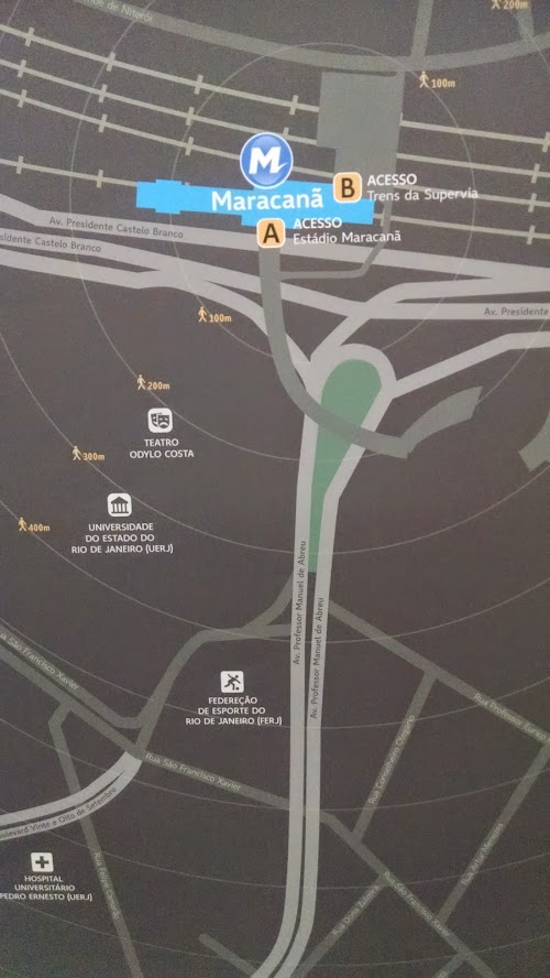
Hi everyone,
here in Rio the subway entrances have a letter to identify them and also a name. Check out this picture of Maracanã subway station map. I've been tagging those as ref=* and name=*. Is there any map that render those? --Nighto (talk) 16:37, 17 June 2014 (UTC)
- Thanks for sharing. I know the answer is quite late, but OsmAnd shows name and ref if present in the format <name> (<ref>) --Nickel715 (talk) 23:33, 9 December 2023 (UTC)
Station entrance or subway entrance?
I'm seeing this tag used for surface stations, like Wembley Park. The logic being used is that it is a subway network, but, if it serves a purpose for surface stations, it would seem equally valid for all surface stations, not those traditionally associated with subway networks.
A more interesting Wembley case is probably Wembley Central, where the entrance is shared between "Underground", "Overground" and national rail services, with the first two sharing platforms. There is no split between Underground and Overground and the split with national rail is inside the barriers.
My feeling is that the use for surface stations is wrong and the tag definition needs tightening, but if its correct, I would argue this should be renamed to station_entrance and applied to all stations. I would say that building entrance coding is sufficient for surface stations.
- What about public transport=entrance? That could work for surface and underground stations, but as far as I know this tag only shows up in the main map (yes, I know that we should not map for the renderers but so far there's no established equivalent for other rail modes). --Amaroussi (talk) 17:17, 7 July 2014 (UTC)
Looking back, this tag is a specific kind of station entrance. Why not use the already established tag entrance=*? It would cover all kind of entrances: underground or surface. And maybe it could be added to public_transport=stop_area when it exists. --Oligo (talk) 21:11, 15 December 2015 (UTC)
Steps/conveying
I've seen people tag subway_entrances with "steps=yes", which makes sense to indicate that there are steps there. What do people think? IMHO it's good that the tag is attached to the subway_entrance node, so that the user can just list those, and knows about the station access, irrespective of whether other features around the node have been mapped. The presence of a lift would be indicated by wheelchair=yes. Should one also add "conveying=yes" if there's a conveyor? Bjohas (talk) 12:24, 5 July 2016 (UTC)