Australia/Archive/Victoria (old)


This project is to help co-ordinate, guide and help people out with mapping the second smallest state in Australia which includes the second largest urban area in Australia.
Victoria has a sophisticated road network consisting of four lane country freeways, two lane country highways, thousands of kilometres of town-connecting two lane sealed roads as well as tens of thousands of kilometers of local roads. This project has been put in place to help with this massive task.
User activity around Metropolitan Melbourne
Thanks to Ito World's fancy application, OSM Mapper, a map of Melbourne users which are mapping parts of our great city can now be produced!

Interactive map of Melbourne

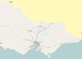
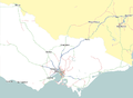
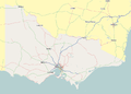
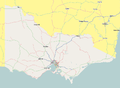
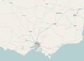
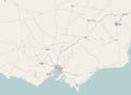
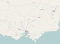
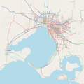
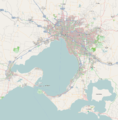
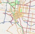
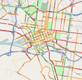
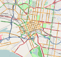
Current status of Victoria, Australia
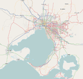
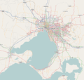
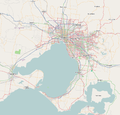
Here are three views of primary areas covered by Victoria, Australia mapping project. New image captures will be uploaded at random intervals. The last captures were collected from the Mapnik Slippy Map on September 23, 2009. The image sizes and scales are now of a set standard, so from the July 7, 2008 renders onwards, they will consist of the same image dimensions and map scales.
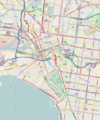
Victoria

Previous captures
-
 September 26, 2007
 -
 November 24, 2007
 -
 February 26, 2008
 -
 April 24, 2008
 -
 July 7, 2008
 -
 September 5, 2008
 -
 September 23, 2009


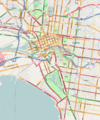
Metropolitan Melbourne

Previous captures
-
 September 26, 2007
 -
 November 24, 2007
 -
 February 26, 2008
 -
 April 24, 2008
 -
 July 7, 2008
 -
 September 5, 2008
 -
 September 23, 2009


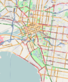
Inner Melbourne

Previous captures
-
 September 26, 2007
 -
 November 24, 2007
 -
 February 26, 2008
 -
 April 24, 2008
 -
 July 7, 2008
 -
 September 5, 2008
 -
 September 23, 2009


Specific Municipalities/Towns
We need your help to map a free map of Melbourne and Victoria. A map which is as error free and up to date as possible. If you have a GPS system, help us with making traces. If you want to fill in information from the aerial imagery, press the 'edit' tab on the main map page. Help make Melbourne the worlds most mappable city! ;)
Plan

This is broken down into various areas with priority roughly related to the following order. This method of prioritising is applicable at the level of the whole state as well as at a local level. For example, a user who wishes map their local region could begin with the major roads before moving onto local roads and finally completing features.
Major Highways / Roads
The major road network throughout Victoria includes national highways, roads of national importance (federally funded roads), arterial roads (highways) that are state [declared roads] (freeways and arterial highways) and toll roads (CityLink and EastLink). These are general classified as "motorway", "trunk" and "primary" highways in OpenStreetMap.
Refer to Victorian Routes for a list of all numbered routes across Victoria.
For an objective view of what roads have been mapped across the State, refer to progress of mapping.
Melbourne Metropolitan Area
The primary goal is to complete all main roads and highways first.
Roads are categorised by status from the VicRoads Country Street Directory of Victoria:
- M class freeways =
highway=motorway(blue while editing) - M class highways and A class highways/roads =
highway=trunk(green while editing) - B class highways/roads =
highway=primary(maroon while editing) - C class highways/roads =
highway=secondary(orange while editing) - Major local roads not classified under C class =
highway=tertiary(light creamy yellow while editing)
The following are categorised from the Melway Street Directory of Greater Melbourne:
- Major Roads (orange in Melway) / Collector Roads (purple in Melway) =
highway=tertiary(light creamy yellow while editing) - Residential Roads (brown in Melway) =
highway=residential(grey while editing)
Try to fill in roads in that order including mapping dual carriageways including median breaks. Other features come later but editors are not restricted to this plan. They can edit any part of the map in anyway they like as long as features exist in the real world.
Roads that are proposed or under construction
If a road is proposed, mark the road with highway=proposed and proposed=road category. In place of road category, type for example, motorway, primary or secondary. These will render dotted lines on the Mapnik and Osmarender slippy maps. For something to count as "proposed" (and not just dreamt of, wished for, promised...) there must be an announcement of funding from a government specifically for the construction, with an estimated start date.
If a road is under construction, mark the road with highway=construction as well as construction=road category.
Under construction
(please add)
City and town marking
When labelling towns on the maps, use this as a guide. For town populations, search for the town on Wikipedia but make sure to search for the town like this: "Town Name, Victoria" to obtain the page. Most articles on the towns have a population figure.
> 50,000 - place=city (The only places with this label should be Melbourne, Geelong, Ballarat and Bendigo.)
5000 - 50,000 - place=town (This category is also to be used for major suburban centres. e.g. Ringwood, Dandenong, Frankston)
Irrelevent of size, "place=suburb" gets used for every Melbourne, Geelong, Ballarat and Bendigo suburb.
Public transport
- Main article: Public transport in Victoria (Australia)
Public transport tagging across Victoria is currently transitioning to the PTv2 tagging scheme, starting in Melbourne. Guidelines for tagging public transport routes, stops and infrastructure, and tagging progress lists of routes, are being compiled at the above page. Contributions welcome!
Melbourne's Bicycle Network
With the addition of the Cycle Map to the main OpenStreetMap map viewer, it is appropriate to mark cycle routes around Melbourne so they appear on the new map, which will make cycling in and around Melbourne much easier.
| Tag | Comment |
|---|---|
type=route |
This specifies that the relation is a route |
route=bicycle |
This specifies that the route is a bicycle route |
network=lcn/rcn |
This specifies the type of cycle route. For local council fingerboard routes mainly along local streets, use "lcn". For major on-road and off-road routes, use "rcn". |
name=Cycle route name |
The name of the track or route. (For example: EastLink Trail) - This displays the name of the route on the way itself |
Most major bike paths have been mapped in some fashion, but one outstanding task is adding all the entries and exits. That is, every time a bike path passes near a street or footpath, there should be a path linking them. This allows GPSes and sites such as cloudmade.com to find routes using the bicycle network, when in "bicycle mode".
Street data sources
Street Names
Street names can not be gathered from copyrighted material (Melways, Google Maps, etc.). Usually this means visiting the streets and writing down all the details. For metropolitan Melbourne, the MMBW Melbourne Sewerage Plans 1890s-1950s are out of copyright and are available from the State Library of Victoria's MMBW map viewer. Some of the streets within an area over time will have changed in name or status, but it is a good first pass. Confirmation and modifications can be done at a later stage by visiting the streets. The lowest and second lowest zoom levels of the Index plans are good for viewing street names, although they may technically still be under copyright as they may have been produced in the 1970s.
The OSM Australia web site is hosting scans of an out-of-copyright 1936 Collins Street Directory of Melbourne. Despite the age of the maps, the street names are surprisingly accurate.
Use of data obtained from VicRoads
The full VicRoads copyright statement is as follows:
Copyright of material presented on the VicRoads web site is owned by VicRoads. Unless otherwise stated, the reproduction, publication, performance, communication or adaptation of the material presented on this web site is permitted, provided that VicRoads is acknowledged as the copyright owner, the material is not modified or treated in a manner prejudicial to the purposes of VicRoads, there are no specific overriding copyright conditions relating to the material, and no charge, claim or encumbrance is made upon any recipient of the material.
Using Vicroads data in OSM may breach the Vicroads licence by:
- Permitting charging for data - which is permitted by CC-SA, but not by the Vicroads licence.
- Permitting modification of the Vicroads data, which OSM does, but is not permitted by the Vicroads licence
- Relicencing the Vicroads data, which OSM does, but is not permitted by the OSM licence.
- Not acknowledging Vicroads data on the produced maps.
Aerial imagery coverage for Melbourne and Geelong
The following map shows the combination of aerial imagery coverage by Yahoo! (in blue) and NearMap (in red), with areas where both providers have coverage (in pink), as of January 20, 2010.

Yahoo! and NearMap have both stopped providing data suitable for use with Open StreetMap. Microsoft has allowed Bing's satellite and aerial photography to be used for tracing, and many Open StreetMap tools show those tiles as a guide.
Ski areas
- Mt Hotham - most lifts, very few trails
- Lake Mountain (XC) - complete except for Heath Trail
- Mt Baw Baw - 0%
- Mt Buller - many lifts, few trails
- Falls Creek
Users
- User:Glen
- User:Brett
- User:Lakeyboy
- User:ianaf4you
- User:gaffa
- User:dmm_au
- User:rgmerk
- User:BlueMM
- User:Mlenser
- User:Ronrib
- User:Rhubarb
- User:Canley
- User:Yoda15
- User:Craigfeuerherdt (includes cake diagram & table for Bendigo)
- User:Rjhunter
- User:Philam48 (also contact for Maptime Melbourne group)
Useful Resources
Please respect the copyright of these sites:
- Wikipedia's Highways in Victoria page
- Wikipedia's Freeways in Victoria page
- Main Roads Victoria on Ozroads
- Freeway Vic
- Brad's Australian Highways Page
- Victoria's Road Network (pdf)
- Australian Towns, Cities and Highways
- Land Channel Interactive Map
- Victorian Registrar of Geographic Names
- data.vic.gov.au - Victorian Government public sector information (mostly CC Attribution 2.5 Australia)