Community Updates/2011-05-09
Community Update from 09 May 2011 to 15 May 2011 (week 2011-19)
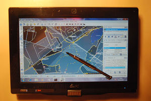
Image Of the Week 2011-19Testing JOSM on a touch-screen Asus tablet |
Project Of The Week : Gyms and Dojos
A sports centre caters to several or many individual sports by providing the infrastructure for participants in those sports. A racquet sports centre might include playing courts for tennis, squash and racquetball among others. A general sports centre might include a multi-purpose gymnasium, outdoor fields for soccer, rugby, football and baseball and indoor and outdoor courts for volleyball. A sports centre might include a gym for strength and flexibility exercises but is distinguished from amenity=gym by the presence or dominance of multiple sport infrastructure.
Quick News
- Use MapCraft to splitup areas for Mapping parties
- Mapnik now displays
addr:housename=* - Over 400.000 mappers registred [1]
- A history extract service launched (splits Planet.osm/full)
- Description of a new file format called "O5m" containing OSM data (can be processed with Osmconvert)
Events
Software
- MapQuest now has a Static Maps API, too [2]
- QualityStreetMap is now 2.0 [3]
- New JOSM plugin for improving ways accuracy
- New release (1180) of Maperitive
Other News
Voting Process validity
A new proposal was made some time ago. The author had created a wiki page and set his proposal to proposed state quickly after the voting phase. After the voting phase, the conclusions were that people support his proposal... But ... the author didn't send a mail to the tagging list as described in the "guide lines". So another user felt that the process was not followed correctly and reverted the proposal to a RFC state.
People on the list tend to think that the voting phase should not be reverted but maybe extended after sending the right email. People called to mind that the "voting process" is only one way to share documentation about a tagging scheme and to look to other mappers for advice.
Multiple Website tags
There are multiple suggested tags for an element's URL/website: url=*, website=*, contact:website=*.
These inconsistencies are mainly due to different creation dates and different ways of organizing information.
In OpenStreetMap everyone can use the tag they prefer to use.
RFC: Highways as an Area
Did you ever want to represent the width/area occupied by a highway? One possibility is to add width=* to your object but some people feel that this is too limited, and they want to delineate the exact boundary of the highway area. This new proposal is about mapping highways as areas without changing the mapping approach of the basic road grid of OSM
Check the proposal and leave your comments on the Talk page
Voting On Shelter Type
The previously described proposal for adding a tag to distinguish bus shelters from alpine huts is now at the voting phase.
Please add your votes on the given page.
Leaflet - A new JS library for Maps
You probably already know OpenLayers, the famous JS library used to display the main OSM map and nearly every OSM based map (and others too). Alternatives to OpenLayers are listed on Deploying your own Slippy Map. Cloudmade has now created another one called "Leaflet"
You can get the leaflet code on Github (BSD licenced) or go to the official leaflet website.
RFC : Tunnel ADR Category
ADR is a set of rules governing transport of hazardous materials by road, produced by UNECE. It is responsible for those yellow/orange diamond-shaped signs on trucks with a UN substance number and particular hazard warnings. This proposal is about adding tag tunnel:adr_category=* to manage the ADR category.
Please add your comments on the Given page.
More.
Thanks
Big thanks to AndiPersti, Stephan75 and !i! !

