Cyprus/Public Transport
This page is intended for the documentation of public transport in Cyprus.
*The instructions follow the New Public Transport Schema version 2 (PTv2).
Mapping the stops
All names of bus/trolleybus stops will be written in capital letters, exactly as they appear on the stops.
Each stop will have two nodes:
1. ![]() node for the stop located on the pavement as
node for the stop located on the pavement as public_transport=platform and highway=bus_stop with tags:
| Key | Value | Comment | Recommendation |
|---|---|---|---|
| public_transport | platform |
Defines this way or area as a platform where passengers are waiting for the vehicle. If there is no platform in the real world, one can place a node at the pole. | mandatory |
| area | yes / no | If the platform is an area. | recommended if yes, else optional |
| name | Individual name | The name by which the platform is known. | recommended if no public_transport=stop_area exists, else optional
|
| ref | Reference | The reference by which the platform is known. | recommended if no public_transport=stop_area exists or differs, else optional
|
| uic_ref | UIC reference | The UIC reference by which the platform is known. | recommended if no public_transport=stop_area exists, else optional
|
| uic_name | UIC name | The UIC name by which the platform is known. | recommended if no public_transport=stop_area exists, else optional
|
| operator | Operator | Name of the company that operates the platform. | recommended if no public_transport=stop_area exists, else optional
|
| network | Local / regional network | Name of the network the stop position belongs to | recommended if no public_transport=stop_area exists, else optional
|
| shelter | yes / no | If there is a shelter that is not tagged separately with amenity=shelter. |
recommended if yes, else optional |
| bench | yes / no | If there is a bench that is not tagged separately with amenity=bench. |
recommended if yes, else optional |
| covered | yes / no | For platforms under the surface. This does not replace a correct layer key. | recommended if yes, but not needed if there is a specific structure (other than a general landuse classification) on a higher layer covering the whole platform. |
2. ![]() node for the point where the vehicle stops on the road as
node for the point where the vehicle stops on the road as public_transport=stop_position with tags:
| Key | Value | Comment | Recommendation |
|---|---|---|---|
| public_transport | stop_position |
Defines this point as a stop position of the vehicle. | mandatory |
| bus | yes / no | If at this stop position stop buses. | recommended if yes, else optional |
| name | Individual name | The name by which the stop position is known. | recommended if no public_transport=stop_area exists, else optional
|
| ref | Reference | The reference by which the stop position is known. | recommended if no public_transport=stop_area exists, else optional
|
| uic_ref | UIC reference | The UIC reference by which the stop position is known. | recommended if no public_transport=stop_area exists, else optional
|
| uic_name | UIC name | The UIC name by which the stop position is known. | recommended if no public_transport=stop_area exists, else optional
|
| operator | Operator | Name of the company that operates the stop position | recommended if no public_transport=stop_area exists, else optional
|
| network | Local / regional network | Name of the network the stop position belongs to | recommended if no public_transport=stop_area exists, else optional
|
For each stop that is created, a relation will be created as public_transport=stop_area
In each of these relations the stop and platform of each stop will be listed, each stop will have its own relation with its own name.
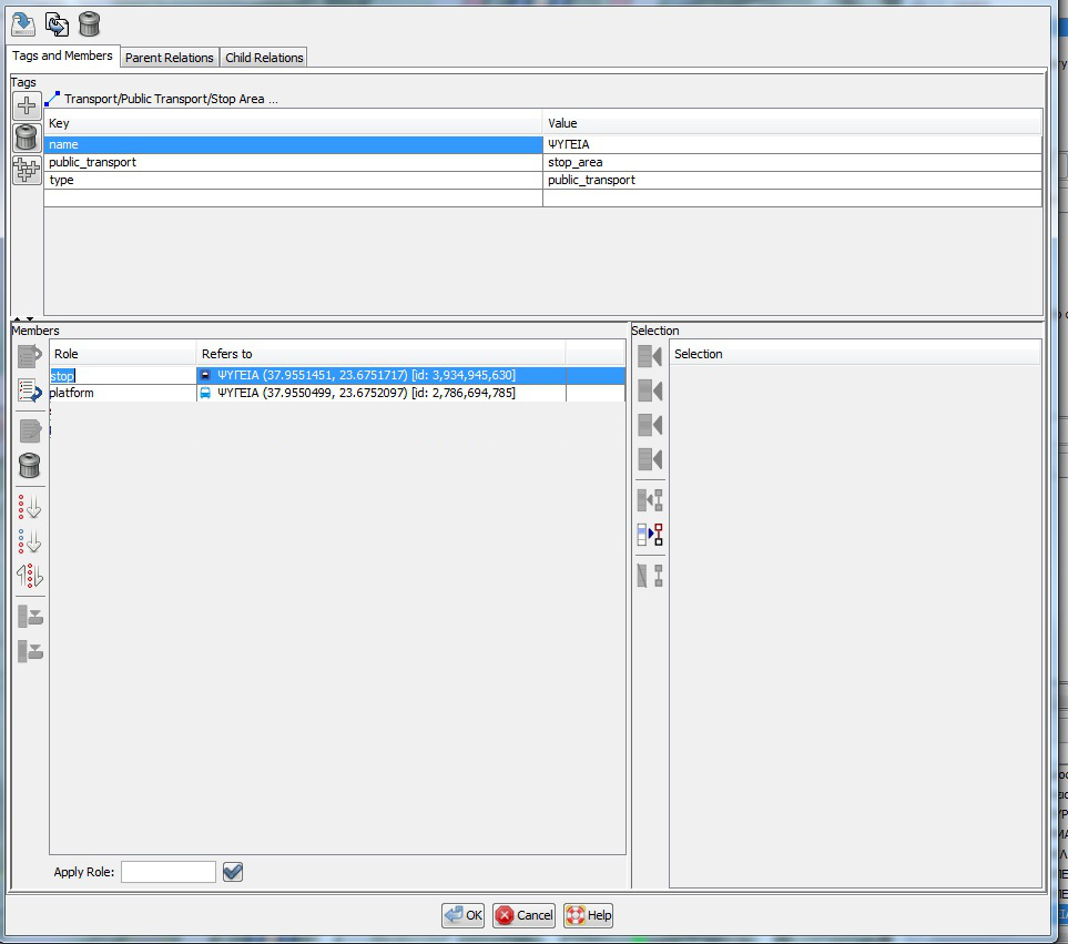
Example (in Josm) with tags and members for stop_area relation.
Creation of bus routes
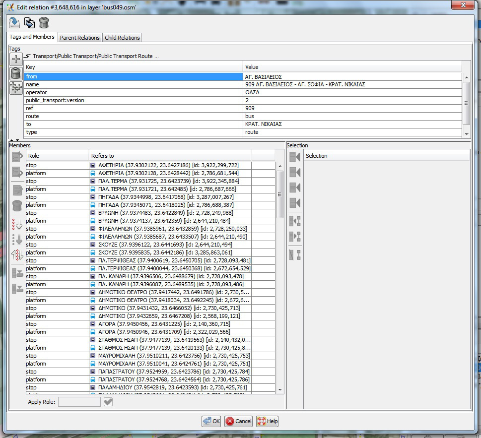
Two route relations will be created one for each direction ("Start = > Finish", "Finish = > Start"). In each route relation the above nodes will be registered as members. In this list for each stop the stop_position will be registered first with role stop and then the platform with role platform following the sequence of stops that the bus/trolley follows in each route.
Example (in Josm) route relation with tags and members in correct sequence:
Tags from=* and to=* we put the names of the initial and final stop respectively.
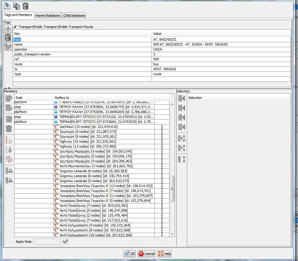
Έπειτα, αμέσως μετά τις στάσεις στην λίστα του route relation θα καταχωρούνται οι δρόμοι (ways) πάλι με την ίδια αλληλουχία που ακολουθεί το λεωφορείο / τρόλεϊ.
Παράδειγμα (στο Josm) route relation με τα tags και τα μέλη (members). Παρατηρούμε ότι δεξιά από κάθε δρόμο (way) υπάρχει ένα βέλος.
Αν όλα τα βέλη φαίνονται ενωμένα όπως στην παρακάτω εικόνα, με μια κόκκινη τελεία στον πρώτο δρόμο και μία στον τελευταίο,
τότε η αλληλουχία είναι σωστή. Αν υπάρχουν κόκκινες τελείες ενδιάμεσα και σε άλλους δρόμους τότε η αλληλουχία δεν είναι σωστή.
Επίσης χρήσιμο για το OSM είναι να "ξέρει" ότι οι δύο παραπάνω διαδρομές ανήκουν στην ίδια λεωφορειακή γραμμή. Για αυτό καλό είναι να δημιουργείται και ένα relation type=route_master στο οποίο θα καταχωρούνται οι δύο παραπάνω διαδρομές (relations).
Στο name βάζουμε το επίσημο όνομα της λεωφορειακής γραμμής από τον ΟΑΣΑ
Παράδειγμα (στο Josm) route_master relation με τα tags και τα μέλη (members).
Αν η διαδρομή αναφέρεται από τον ΟΑΣΑ ως κυκλική τότε θα έχει μόνο ένα route relation με ίδια from=* και to=*, και επίσης καταχωρούμε την ίδια αρχική-τελική
στάση δύο φορές, μια στην αρχή της λίστας των στάσεων και μία στο τέλος.


