Dual carriageway


A ![]() dual carriageway (known as a divided highway in American English) is a road with two carriageways (roads in each direction) that are physically divided by a non-road barrier, median, or other obstacle. This is done to separate high speed traffic, allow usage of the middle of the road, or accommodate new lanes. Motorways/expressways, trunk roads, and even lower classifications of roads are often split and defined as dual carriageways. This page explains the definition and mapping of dual carriageways in OSM. Government transportation departments or other organizations may classify dual carriageways differently.
dual carriageway (known as a divided highway in American English) is a road with two carriageways (roads in each direction) that are physically divided by a non-road barrier, median, or other obstacle. This is done to separate high speed traffic, allow usage of the middle of the road, or accommodate new lanes. Motorways/expressways, trunk roads, and even lower classifications of roads are often split and defined as dual carriageways. This page explains the definition and mapping of dual carriageways in OSM. Government transportation departments or other organizations may classify dual carriageways differently.
A dual carriageway does not have to maintain a median or barrier throughout its entire extent to be mapped as a dual carriageway. For example, primary and secondary roads can have landscaped medians that are meant to separate ways of traffic until a turn lane is accommodated and the median stops. The median usually continues after the intersection, so the road should continue to be mapped as a dual carriageway as long as the median is generally present.
Roads are not to be mapped as dual carriageways if the two directions are only separated
- by paint. This includes single or multiple painted centre lines[1], hatched areas, channelized turn lanes[2], two-way turn lanes[2],
- by flush medians[3],
- or by any other means that is not a physical barrier to vehicles.
Likewise, a highway link should only be drawn alongside the main highway when physically separated from it, with the link starting or ending at the theoretical gore point (where the lanes diverge). Lane change restrictions (like solid lines) preceding links should be mapped using change:lanes=*. The turn:lanes=* tag may also apply to the preceding sections.
How to map
A dual carriageway is mapped with two oneway ![]() Ways tagged with
Ways tagged with oneway=yes. The median in the center could be tagged as area:highway=traffic_island according to proposed features/Street area. If the traffic island serves as a traffic calming device, the tag traffic_calming=island can be added to the two highway=* ways.
Link roads that connect the two carriageways (e.g, a u-turn lane through the median) can be mapped as the appropriate highway=_link.
Some mappers use dual_carriageway=yes on dual carriageway highway=* lines (applicable to all road categories) to make them clearly identifiable.
For mapping dual carriageway intersections, see Junctions#Dual carriageway intersections.
-
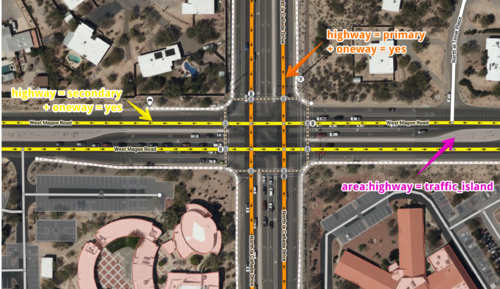 An example of an intersection with two dual carriageways.
 -
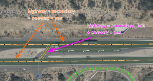 An example of a dual carriageway with a
highway=secondary_linklinking the roads. The link should start or end at the theoretical gore point, andturn:lanes=*andchange:lanes=*should be added to the preceding road as appropriate. Drawing the link along the length of a turn lane should only be done if it is physically separated. -


Examples
Dual carriageways
Multiple dual carriageways present at I-405 at CA 19.


Not dual carriageways
East Grant Road in Tucson, Arizona is not a dual carriageway because of it does not have any physical barrier in between the lanes.


Große Langgasse in Mainz, Germany isn't a dual carriageway because its central reservation, despite the paving stone surface, is flush with the asphalt.


Exceptions
If a road contains any of the non-appropriate elements for some short distance, but is still separated by a physical obstructions along other parts of the road in the vast majority of its length, then the road can continue to exist as a dual carriageway for the moment. These exceptions are typically easy to recognize, and may be kept in-thought of ease of recognition, routing, presence, and functionality of the road, in lieu of more detail. Other exceptions have been made by some users for dual carriageways such as roads like Super twos found in the U.S. Later on, when they are to be micromapped, the sections concerned can be changed back to a single ![]() with appropriate tags such as
with appropriate tags such as change=*.
That being said, when a new dual carriageway is created, extra attention can be taken to avoid drawing 2 ![]() pass the physically separated sections. This would more accurately represent the road's real layout from the beginning, eliminating the need to wait for iterative refinement at some future time.
pass the physically separated sections. This would more accurately represent the road's real layout from the beginning, eliminating the need to wait for iterative refinement at some future time.
Further reading
- Dual vs. Single Carriageways - A guide explaining the government-defined classification of carriageways in the U.S. and how they vary state-to-state by DOT. These classifications do not follow OSM's classification though it explains that OSM-like classification is useful and used in some instances.
References
- ↑ https://mutcd.fhwa.dot.gov/services/publications/fhwaop02090/twtmarkings_longdesc.htm See section Two-Lane Roadways
- ↑ 2.0 2.1 https://mutcd.fhwa.dot.gov/services/publications/fhwaop02090/twtmarkings_longdesc.htm#Multi-Lane_Roadways See section Multi-Lane Roadways
- ↑ https://nzta.govt.nz/driver-licences/getting-a-licence/road-code/flush-medians