Key:expressway
 |
| Description |
|---|
| A highway with high-speed design features and limited access to adjacent properties. Usually a dual-carriageway (divided). |
| Group: highways |
| Used on these elements |
| Requires |
|
| See also |
| Status: de facto |
| Tools for this tag |
An expressway is a highway that is designed for high-speed travel but lacks some of the characteristics that enable a motorway=* (freeway, highway=motorway) to accommodate a high volume of high-speed traffic safely.
For the purpose of this key, an expressway does not necessarily match local colloquial definitions of the term expressway. It largely corresponds to how this term is used by traffic engineers in the United States and United Kingdom. However, it does not mean a motorway=*, which is how the term is normally used in India and in translation from other languages. A similar category of highway, express road, is officially recognized by the governments of some countries. This category overlaps with motorroad=yes, but the two concepts are not identical.[1][2] As defined in OSM, it does not cover certain common meanings of the term "expressway" as used in many countries; in particular, it includes super-2's.
Characteristics
A defining characteristic of an expressway is that there are inconsistencies along the length of the highway. In general, an expressway overall:
- is a dual carriageway (divided highway,
dual_carriageway=yes) - has a higher than usual speed limit and accompanying design features, such as motorway-style signage
- has limited access to abutting properties (
access_control=partial), for example via frontage roads and right-in/right-out intersections
An expressway may connect to some major roads via link roads (ramps) at grade-separated interchanges but may have at-grade intersections with other public roads, with or without traffic signals (highway=traffic_signals). This contrasts with motorways, which are completely grade-separated.
In some regions, highway=trunk and expressway=yes often coincidentally appear on the same highways, but the two tags are not equivalent. Depending on local tagging conventions, highway=trunk may be used for either high-performance or high-importance roads, so it is possible for an expressway to be highway=primary or a highway=trunk to be expressway=no (expressways are high-performance, but importance may vary).
To facilitate higher-speed travel, an expressway typically restricts access to slower modes of transportation, such as pedestrians (foot=*) and cyclists (bicycle=*). However, data consumers should not infer specific access restrictions based on expressway=yes alone, because two expressways may have very different access restrictions. In countries where it is applicable, use motorroad=yes to succinctly describe the kind of access restrictions that are common on expressways. Conversely, data consumers should not assume motorroad=yes means an expressway, because sometimes those access restrictions are applied to roads that meet none of the criteria for an expressway.
Two-lane expressways
expressway=yes is also used on two-lane expressways. This type of road is not a dual carriageway (divided), but generally:
- has a higher than usual speed limit and accompanying design features, such as motorway-style signage
- has all access controlled via interchanges with on/off ramps, and no direct access to abutting properties (
access_control=full)
Essentially a two-lane expressway is a road that would otherwise be a motorway (freeway) if it were a dual carriageway (divided).
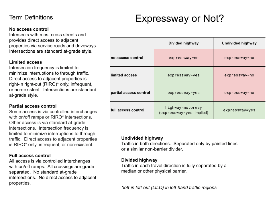
How to decide
dual_carriageway=yes
|
dual_carriageway=no
| |
|---|---|---|
The above table was constructed based on the following image: Expressway or Not
While the value of expressway may often be inferred by other tags, it is especially useful to upgrade or downgrade the performance of a road where highway=* is tagged according to importance.
Rationale
In North America, the term "expressway" is well-established jargon in traffic engineering that essentially matches the definition above. In the USA, the term "expressway" is used in the Manual on Uniform Traffic Control Devices (MUTCD) and other publications of the Federal Highway Administration. For example, the Highway Performance Monitoring System defines an expressway as:
- A divided highway facility with partial control of access[3] and two or more lanes for the exclusive use of through traffic in each direction; includes grade separations at most major intersections. [1]
It is up to individual highway departments to classify a road as an expressway, apparently based on rigorous guidance in the Highway Capacity Manual published by the Transportation Research Board of the National Academies of Science. Based on the MUTCD's specifications, expressways are partially signposted in some cases but not all. The fact that some are signposted at all aligns the concept with the Verifiability rule, but in order for the tag to be useful to data consumers, it needs to be applied consistently across a road network, even where the expressway is implied.
Rendering
expressway=yes is primarily intended for rendering. This key originated in the United States, where road maps conventionally distinguish expressways from freeways and conventional surface streets by a distinct colour, line treatment, or both. This distinction allows maps to highlight convenient routes through areas underserved by freeways but also caution motorists that these convenient routes may be less safe and provide a poorer experience overall and as to caution cyclists and pedestrians that it may be extremely dangerous, even if legal. If a surface road is being upgraded to an expressway in short segments, or if an expressway is being upgraded to a freeway in similar fashion, it would appear as alternating bands on a conventional map, without regard for consistency along the whole road. This alternating effect is to be expected on maps that distinguish expressways, but not on maps that distinguish roads only by their road classifications.
As with some other aspects of cartography, such as highway classification, expressway tagging can be somewhat subjective. Therefore, this key is more appropriate in countries where expressways are explicitly signposted (even partially as in the U.S.) and supported by traffic engineering practices or cartographic conventions.
Routing
Routers need a way to distinguish turn channels from ramps, both of which can be tagged as highway=*_link. Ideally, a router would announce turn channels along surface streets as turns at the associated intersections but ramps along freeways and expressways as entrances or exits. Historically, routers such as Valhalla inaccurately relied on highway=trunk_link connected to highway=trunk to represent an expressway that is more likely to have ramps than turn channels [2], but this assumption fails if highway=trunk is tagged based on connectivity.
If a user chooses to avoid freeways when requesting a route, routers also try to avoid expressways due to similar characteristics. Historically, routers such as OSRM have inaccurately relied on highway=trunk and highway=trunk_link to detect expressways for this purpose. [3]
How to map
If a highway=* way meets the criteria above and there is local consensus that expressways should be tagged explicitly, add expressway=yes to the way. If it is a highway=trunk way but the road does not meet any of the criteria for an expressway, you can use expressway=no to prevent data consumers from assuming it is an expressway for historical reasons.
In addition to expressway=*, consider adding more objective tags to justify your tagging and assist routers:
dual_carriageway=yesoneway=yesif the road is divided into two one-way roads with a physical barrier in the medianmaxspeed=*so that routers do not make a faulty assumption about the speed limit based on the road classificationhighway=motorway_junctionat link roads that are signposted as exit rampshighway=traffic_signalsat signalized at-grade intersections
Add access tags to clarify who can use the road. motorroad=yes may be an appropriate access tag in some regions, especially those that are signatories to the Vienna Convention.
Regional considerations
United States

In the United States, the expressways in a given state or county do not necessarily correspond to a single road classification or designated route network. An expressway may be built for a variety of reasons, including as a stage of construction before upgrading to a freeway, as a workaround for lack of space, or as a political compromise. When an expressway becomes a conventional surface street, the MUTCD calls for a large warning sign to indicate the end of the expressway. Otherwise, the entrances to an expressway are not signposted as such, so an expressway that connects two freeway segments would not have any sign explicitly referring to it as an expressway. However, the road would have guide signs in the style that the MUTCD reserves for freeways and expressways as opposed to conventional roads.
Public awareness of the term "expressway" varies across the U.S. In western states, such as California, a typical motorist is familiar with the distinction between freeways and expressways and uses both terms regularly. Elsewhere, "expressway" has a much broader colloquial definition that is not covered by this tag. As a standard street suffix, it can appear in the name of a variety of roads from freeways to conventional surface streets that lack access control,[3] grade-separated interchanges, or high-speed design. Do not confuse this colloquial definition with the technical one above.
Regional variation in road design can also be a deciding factor. True expressways are rare in the northeast United States, however some roads such as US 11/15 along the Susquehanna River in central Pennsylvania, as well as parts of US 22 in western Pennsylvania, can be said to be "expressways" relative to the typical regional road network.
expressway=yes can also refer to a "Jersey freeway", which is a divided road (typically a jersey barrier and narrow overall footprint) with high-speed design and grade separations. Unlike a standard expressway, however, it does have frequent access to adjacent properties, but has few or no at-grade intersections with other public roads.
Unlike motorroad=yes, expressway=yes does not imply access restrictions by default. Explicitly add access tags to an expressway based on signs posted at entrance ramps.
Canada
Usage of the tag in Canada is similar with the United States.
Public awareness of expressways varies across regions and provinces. In the Western provinces (British Columbia, Alberta, Saskatchewan, Manitoba) and parts of Ontario, a typical motorist is familiar with the distinction between freeways and expressways, and uses both terms regularly. In Alberta, expressway- or freeway-grade roads in cities such as Calgary usually have names bearing the suffix "Trail". In Ontario, roads considered expressways under the technical definition usually include RIRO (right-in, right-out) expressways such as parts of Highway 11 north of Barrie and Highway 35/115 in Durham Region, as well as some roads suffixed "Parkway" such as the Hanlon Parkway in Guelph and the Veterans Memorial Parkway in London. Elsewhere, the term has a broader colloquial definition that is not covered by this tag. As a standard street name suffix, it can encompass freeway-grade roads (e.g. the Gardiner Expressway in Toronto) to roads lacking control of access, grade-separated interchanges and high-speed design features. In Quebec, "expressway" is also used as a translation of French autoroute by English-speaking Québécois.
Regional variation in road design can also be an deciding factor. True expressways are common in the western prairie provinces and parts of rural Ontario, but are somewhat less common in Quebec and the Atlantic provinces.
Curaçao (Kingdom of the Netherlands)

Curaçao legislation, similar to the Netherlands, defines a motorroad traffic sign with access restrictions and an elevated default speed limit. However the island country has roads without the motorroad traffic sign, without motorroad access restrictions, but with the motorroad elevated default speed limit (via a speed limit traffic sign). These are tagged with highway=trunk, motorroad=no, expressway=yes.[5]
India
- Main article: India/Tags/Highway
In India, this tag has been used to tag higher-quality dual-carriageway highways in parts of the country, such as highways forming the Golden Quadrilateral connecting India's major cities (Delhi, Mumbai, Chennai, Kolkata). The tag is specifically used for tagging upgraded dual-carriageway highways which feature motorway-like control of access but does not restrict pedestrians, cyclists and slower traffic such as auto rickshaws and agricultural vehicles (where they are restricted, are tagged with motorroad=yes). The term "expressway" in Indian English can either refer to "National Expressways" (such as the Delhi-Agra Expressway, which are signed with the Vienna Convention standard motorway sign ![]() and are tagged
and are tagged highway=motorway) or upgrades or bypasses of National Highways which are built similarly to National Expressways.
Ireland (Republic)
In the Republic of Ireland, this tag has been used to tag high-quality dual carriageways (HQDCs), primary around Dublin. These are dual-carriageways with quality nearly close to those of motorways, including having full grade separation, but may have lay-bys or bus stops, allows most traffic not allowed on motorways (such as pedestrians, cyclists, farm vehicles, learner drivers, etc.), and have a hard shoulder separated by a broken yellow line as opposed to a continuous white line on motorways. Speed limits on HQDCs are usually at 100 km/h (the national speed limit on highways outside built-up areas), though some have the motorway speed limit of 120 km/h or lower limits (90 km/h and below) due to local traffic bylaws. An example of a HQDC is a segment of the N7 between Dublin and Naas.
Poland
In Poland, a "droga ekspresowa" is usually tagged as highway=motorway + highway:class:pl=S and shouldn't be tagged further as expressway=yes.
The tag expressway=yes should be used on the rest of S class roads and roads of the following parameters:
- The road is access-controlled (
access_control=full), - In each direction, there is at least one of the following:
- The speed limit on the majority of the road is above 50 km/h.
Japan
highway=trunk is used for all national roads in Japan despite many of these in rural regions having a basic 2-lane construction with standard intersections, crossings and long sections with maxspeed=50. For these roads, expressway=no can be applied.
Examples
- Aerial examples
-
 A rural expressway segment of U.S. Route 33 near Canal Winchester, Ohio. Note the partial cloverleaf interchange with a major road, the at-grade crossing of minor roads just to the east and west, and the cutoff of a minor road near the interchange.
 -
 A conventional surface road segment of U.S. Route 40 near Alton, Ohio. Note the frequent driveway access.
- Street-level examples
-
 A rural expressway segment of the Appalachian Highway in Carthage Township, Athens County, Ohio. Except for the at-grade intersections with township roads, this segment would meet the criteria for a motorway.
 -
 An urban expressway segment of King's Highway 11 in Severn, Ontario. Note the driveway access immediately preceding the exit ramp.
 -
 An urban expressway segment of Lawrence Expressway in San Jose, California. Due to the high speed limit (even at this traffic signal), the curve in the road is relatively gentle.
 -
 An urban expressway segment of Foothill Expressway in Palo Alto, California. Note the freeway-style guide signs and the median separating northbound and southbound traffic, but also the bike lane.


Rural expressways:
- US 33 in parts of Ohio
- US 48 in West Virginia
- Much of US 15 between Frederick, MD and Harrisburg, PA
Urban/suburban expressways:
- SR 161 in Columbus, Ohio
- US 222 around Trexlertown, PA near Allentown
- US 29 in Maryland between MD 650 and MD 32
- Santa Clara County expressway system
Jersey freeways:
- US 11/15 between Duncannon and Selinsgrove in Pennsylvania
- US 46 and NJ 3 between I-80 and NJ 21
- NJ 17 between NJ 3 and I-287
History
As far back as 2009, there was consensus among mappers in the United States to tag expressways as highway=trunk, regardless of connectivity. This U.S.-centric definition of a trunk road has been questioned on numerous occasions even by U.S.-based mappers, in part because it leads mainstream renderers to treat some Midwestern road networks inconsistently. In 2021, an extended discussion in several venues led to a proposed redefinition of trunk roads that would divorce it from the physical characteristics of an expressway, relegating this distinction to a secondary tag.
The idea for a dedicated key for expressways came out of a 2009 essay by a mapper from Ohio, where expressways are common but motorists have no colloquial term for them. The following year, this key was introduced on 200 ways and a a formal proposal was discussed. Neither it nor a companion proposal about substandard or isolated motorways ever came to a vote. Nevertheless, the key began picking up usage in early 2012, increasing to about 1,400 ways in Ohio and Texas before levelling off. It spread to Pennsylvania in 2017. In 2018, usage began to climb at a much faster pace. [4][5][6] This increase was noted in early 2021 in a discussion about whether the key would also be applicable to Brazil. [7]
Software support
Editors
iD's Trunk Road and Primary Road presets have an "Expressway" checkbox when the selected feature is located in the United States. [8] There is a request for JOSM's map paint style to render expressway=yes like motorroad=yes. [9]
Renderers
OpenMapTiles exposes this tag in its transportation layer. [10] OpenStreetMap Americana renders expressways with a double casing, colored red or black depending on the road classification. [11] TrailStash Liberty renders expressways a shade of orange between it's rendering of trunk/motorway and primary/secondary.[12]
Compare the Apache Baremaps (OpenStreetMap Carto) and OpenStreetMap Americana treatments of various expressways near Indianapolis:
Routers
GraphHopper assigns default speed limits based on expressway=yes in some regions where the speed limits are tied to a legal definition of "expressway" that closely matches this tag. [13]
There is a request for Valhalla to treat expressway=yes like highway=motorway for some purposes (preferring or avoiding highways and distinguishing between ramps and slip lanes) instead of assuming that every highway=trunk is an expressway. [14]
Notes and references
- ↑ “Express road”. Glossary for transport statistics. Luxembourg City: Publications Office of the European Union. 2019. p. 34.
- ↑ “Express road”. Statistical Terms Glossary. Beirut: United Nations Economic and Social Commission for Western Asia. Retrieved October 3, 2024.
- ↑ 3.0 3.1 In this context, access control refers to measures that prevent a motorist from directly accessing other roads or abutting properties. It does not refer to restrictions on who can access the road itself.
- ↑ A similar sign exists in New Zealand, where "expressway" contrasts with "motorway". However, the meaning of these two terms in NZ English has no correlation to what the terms mean in OSM.
- ↑ The Netherlands roads tagging