Proposal:Expressway indication
| This proposal is abandoned and never received vote, current status of this tag is described at Key:expressway |
| Expressway indication | |
|---|---|
| Proposal status: | Abandoned (inactive) |
| Proposed by: | Vid the Kid |
| Tagging: | expressway=yes(/no)
|
| Applies to: | ways |
| Definition: | Tagging for expressways without forcing a specific highway=* value
|
| Statistics: |
|
| Rendered as: | According to highway=* but with blue casing like that of highway=motorway
|
| Draft started: | 2010-07-13 |
| RFC start: | 2010-07-14 |
| Vote start: | * |
| Vote end: | * |
Quick definitions
An Expressway is much like a freeway/motorway, with its high-speed design features and no access to adjacent properties, but unlike a freeway, an expressway may have at-grade intersections with other public roads. Expressways typically have signage similar to that of a full freeway. A "conventional road", by the way, is a road that is not a freeway or expressway, and allows direct access to homes and businesses along it. This terminology comes from the Manual on Uniform Traffic Control Devices. (Many freeways, expressways, or even conventional roads in the US have names that end with "expressway". This proposal is based strictly on the definitions above, regardless of whether "expressway" appears in a road's name.)
Proposal
The core of this proposal is to indicate that a road is physically an expressway by using expressway=yes. Additionally, expressway=no can be used to indicate to other mappers that the road is a conventional road, in the presence of evidence that might suggest otherwise — such as on a highway=trunk.
Note that, while this proposal may affect what highway=* value is used in some situations, and an enhancement to rendering is suggested, the proposal is backwards-compatible. That is, even without updating the renderer, following this proposal will not make maps unusable or wrong.
Rationale
Distinguishing expressways from freeways or conventional roads is important. An expressway typically has the high speed and many other niceties of engineering that come with freeways. A motorist on an expressway might mistakenly refer to an expressway as a freeway due to the degree of physical similarity. Expressways should therefore be shown more prominently than conventional roads. At the same time, at-grade intersections present a specific hazard to motorists, which does not exist on freeways. It is for this very good reason that most maps don't indicate expressways the same way as full freeways.
Currently, expressways may be indicated by highway=trunk or not indicated at all. Since highway=trunk itself does not strictly mean the road is an expressway, this is inadequate.
Additionally, there seems to be a prevailing philosophy, expressed on this wiki and in the OpenStreetMap data, that highway=* should indicate a roadway's role in the greater highway network, and that a road's physical characteristics should be expressed in other tags. Considering expressway nature to be a physical characteristic, I propose this new tag. Along with Proposed features/Motorway indication, this separation of form and function can be made complete.
Examples
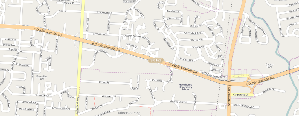
- Typical rural expressway: US 30 in parts of Ohio. OSM Google
- Urban expressway: SR 161 in Columbus, Ohio. OSM Google
If you know what to look for, it's not too hard to find expressways in urban or rural locations throughout the US and other countries. Wherever highway engineers want to increase speed and safety, but can't justify the expense of a full freeway/motorway, an expressway is built.
Implied tags
highway=trunk can, for some regions, be a hint to editors that the road might be an expressway. Local knowledge and/or analysis of aerial photography is necessary to make this determination.
expressway=yes implies:
oneway=yesunless otherwise taggedfoot=nounless otherwise taggedbicycle=nounless otherwise tagged
Useful combinations
Applies to
- ways (roads, also tagged
highway=*)
Rendering
Roads tagged with expressway=yes should be rendered according to their highway=* tags, except the casing should be blue like the casing of a highway=motorway. Additionally and if practical, roads tagged expressway=yes should have the same width as a road tagged highway=motorway. The core color should be the same as a conventional road of the same highway=* class.
Rendering of ways tagged bridge=yes or tunnel=yes may remain unaltered by expressway=yes. Values of expressway=* other than "yes" should not have any impact on rendering. Rendering of ways tagged with values of highway=* other than "trunk", "primary", "secondary", or "tertiary" — such as highway=residential or highway=bridleway — should not be altered by expressway=*.
For an example rendering of highway=secondary+expressway=yes, in context of other roads, see Media:Secondary Expressway Rendering Mockup.png
Low Zoom
Open to suggestions on how to differentiate expressways at low-zoom map scales which don't use cased lines.
Routing
Routing applications should take note of expressway=yes, as well as highway=motorway or motorway=yes. Generated routes should probably not start or end directly on roads tagged this way, though in some cases this may be desired. Certainly, when determining the nearest-point-on-road to a geocoded address, roads with these tags are to be excluded from the search. (Buildings located next to a freeway or expressway are typically not accessed directly from that freeway or expressway.)
Comments
Please use the discussion page for comments.
Tagging
| Tag | Description | Notes | Photo |
|---|---|---|---|
highway=*
|
The functional role played by the road in the greater highway system. | Don't omit this; expressway=* is meaningless without it.
|
|
expressway=yes
|
The road is an expressway. | 
| |
expressway=no
|
The road is not an expressway, but a conventional road. | Default treatment of roads without expressway=* tag. Explicitly stating this is more of an indication to other mappers, than to users of OSM data.
|
See Also
Voting
Voting has not started yet.